


<< Other Photo Pages >> Burra Ness broch - Broch or Nuraghe in Scotland in Shetland
Submitted by Andy B on Wednesday, 21 April 2010 Page Views: 5474
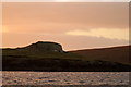
Iron Age and Later PrehistorySite Name: Burra Ness brochCountry: Scotland
NOTE: This site is 0.228 km away from the location you searched for.
County: Shetland Type: Broch or Nuraghe
Map Ref: HU55729569
Latitude: 60.640658N Longitude: 0.983112W
Condition:
| 5 | Perfect |
| 4 | Almost Perfect |
| 3 | Reasonable but with some damage |
| 2 | Ruined but still recognisable as an ancient site |
| 1 | Pretty much destroyed, possibly visible as crop marks |
| 0 | No data. |
| -1 | Completely destroyed |
| 5 | Superb |
| 4 | Good |
| 3 | Ordinary |
| 2 | Not Good |
| 1 | Awful |
| 0 | No data. |
| 5 | Can be driven to, probably with disabled access |
| 4 | Short walk on a footpath |
| 3 | Requiring a bit more of a walk |
| 2 | A long walk |
| 1 | In the middle of nowhere, a nightmare to find |
| 0 | No data. |
| 5 | co-ordinates taken by GPS or official recorded co-ordinates |
| 4 | co-ordinates scaled from a detailed map |
| 3 | co-ordinates scaled from a bad map |
| 2 | co-ordinates of the nearest village |
| 1 | co-ordinates of the nearest town |
| 0 | no data |
Internal Links:
External Links:
I have visited· I would like to visit
Andy B has visited here
")
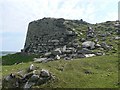
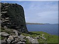
This broch stands about 12 feet high on the seaward side, overlooking Bluemull Sound, although it has tumbled down on the landward side.
You may be viewing yesterday's version of this page. To see the most up to date information please register for a free account.
")
")
Do not use the above information on other web sites or publications without permission of the contributor.
Nearby Images from Geograph Britain and Ireland:
©2007(licence)
©2007(licence)
©2012(licence)
©2016(licence)
©2016(licence)
The above images may not be of the site on this page, they are loaded from Geograph.
Please Submit an Image of this site or go out and take one for us!
Click here to see more info for this site
Nearby sites
Key: Red: member's photo, Blue: 3rd party photo, Yellow: other image, Green: no photo - please go there and take one, Grey: site destroyed
Download sites to:
KML (Google Earth)
GPX (GPS waypoints)
CSV (Garmin/Navman)
CSV (Excel)
To unlock full downloads you need to sign up as a Contributory Member. Otherwise downloads are limited to 50 sites.
Turn off the page maps and other distractions
Nearby sites listing. In the following links * = Image available
3.1km SE 140° Sna Broch* Broch or Nuraghe (HU5779393326)
3.8km SE 143° Brough Lodge Broch* Broch or Nuraghe (HU5806392653)
4.8km N 1° Hoga Ness broch* Broch or Nuraghe (HP557005)
5.6km NE 48° Uyea Cairn* Cairn (HU599995)
6.1km N 5° Ness of Wadbister Broch or Nuraghe (HP56200180)
6.3km ESE 118° Stackaberg Cairn* Cairn (HU6128692786)
6.6km ESE 115° Whilsa Pund* Ancient Village or Settlement (HU61789295)
6.8km ESE 117° Fidlers Crus* Stone Circle (HU6179592690)
6.8km NE 45° Clivocast Standing Stone* Standing Stones (HP60440055)
6.8km ESE 109° Vord Hill South* Chambered Cairn (HU6217593553)
6.8km ESE 108° Vord Hill North* Chambered Cairn (HU6222193670)
6.9km ESE 109° Vord Hill 3* Cairn (HU6225193504)
7.0km NE 45° Uyea Breck* Standing Stone (Menhir) (HP60610071)
7.1km N 10° Snabrough broch* Broch or Nuraghe (HP568027)
7.1km W 275° Lumbister, N Yell* Multiple Stone Rows / Avenue (HU486962)
7.2km NNE 29° Gletna W* Stone Circle (HP59160206)
7.3km ESE 118° Hjaltadans* Stone Circle (HU6220892397)
7.9km NNE 17° Lund Stone* Standing Stone (Menhir) (HP57870334)
8.2km SE 131° Houbie Broch* Broch or Nuraghe (HU61969035)
8.5km NNE 13° Burragarth* Standing Stone (Menhir) (HP57540397)
8.7km SE 128° Ripple Stone (Fetlar) Standing Stone (Menhir) (HU62699044)
8.8km NNE 22° Gunnister Stone* Carving (HP58840391)
8.8km NNE 19° Gunnister Standing Stone Standing Stone (Menhir) (HP5841704120)
8.9km NNE 12° Underhoull* Broch or Nuraghe (HP575044)
8.9km NE 44° Sand Wick Burial Ground* Ancient Village or Settlement (HP6185102202)
View more nearby sites and additional images


 We would like to know more about this location. Please feel free to add a brief description and any relevant information in your own language.
 Wir möchten mehr über diese Stätte erfahren. Bitte zögern Sie nicht, eine kurze Beschreibung und relevante Informationen in Deutsch hinzuzufügen.
 Nous aimerions en savoir encore un peu sur les lieux. S'il vous plaît n'hesitez pas à ajouter une courte description et tous les renseignements pertinents dans votre propre langue.
 Quisieramos informarnos un poco más de las lugares. No dude en añadir una breve descripción y otros datos relevantes en su propio idioma.