


<< Our Photo Pages >> All Saints (Hovingham) - Ancient Cross in England in Yorkshire (North)
Submitted by TimPrevett on Saturday, 19 May 2007 Page Views: 4641
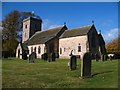
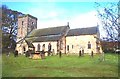
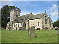
Early Medieval (Dark Age)Site Name: All Saints (Hovingham)Country: England
NOTE: This site is 0.179 km away from the location you searched for.
County: Yorkshire (North) Type: Ancient Cross
Nearest Town: Hovingham
Map Ref: SE6665575705
Latitude: 54.172817N Longitude: 0.980412W
Condition:
| 5 | Perfect |
| 4 | Almost Perfect |
| 3 | Reasonable but with some damage |
| 2 | Ruined but still recognisable as an ancient site |
| 1 | Pretty much destroyed, possibly visible as crop marks |
| 0 | No data. |
| -1 | Completely destroyed |
| 5 | Superb |
| 4 | Good |
| 3 | Ordinary |
| 2 | Not Good |
| 1 | Awful |
| 0 | No data. |
| 5 | Can be driven to, probably with disabled access |
| 4 | Short walk on a footpath |
| 3 | Requiring a bit more of a walk |
| 2 | A long walk |
| 1 | In the middle of nowhere, a nightmare to find |
| 0 | No data. |
| 5 | co-ordinates taken by GPS or official recorded co-ordinates |
| 4 | co-ordinates scaled from a detailed map |
| 3 | co-ordinates scaled from a bad map |
| 2 | co-ordinates of the nearest village |
| 1 | co-ordinates of the nearest town |
| 0 | no data |
Internal Links:
External Links:
I have visited· I would like to visit
MAIGO kelpie rldixon have visited here
 (PID:75199)")
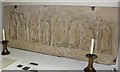
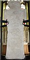
Several pre-Norman crosses and fragments within All Saints' Hovingham. Some are built into the church fabric, a couple on the outside.
You may be viewing yesterday's version of this page. To see the most up to date information please register for a free account.
 (PID:55145)")
 (PID:55144)")
 (PID:55143)")
 (PID:109494)")
Do not use the above information on other web sites or publications without permission of the contributor.
Nearby Images from Geograph Britain and Ireland:
©2009(licence)
©2009(licence)
©2010(licence)
©2006(licence)
©2012(licence)
The above images may not be of the site on this page, they are loaded from Geograph.
Please Submit an Image of this site or go out and take one for us!
Click here to see more info for this site
Nearby sites
Key: Red: member's photo, Blue: 3rd party photo, Yellow: other image, Green: no photo - please go there and take one, Grey: site destroyed
Download sites to:
KML (Google Earth)
GPX (GPS waypoints)
CSV (Garmin/Navman)
CSV (Excel)
To unlock full downloads you need to sign up as a Contributory Member. Otherwise downloads are limited to 50 sites.
Turn off the page maps and other distractions
Nearby sites listing. In the following links * = Image available
2.4km NNW 335° Stonegrave Minster* Ancient Cross (SE6561077885)
3.4km N 359° All Saints and St James (Nunnington) Ancient Cross (SE6657079070)
5.6km NW 306° St Oswald (Oswaldkirk)* Ancient Cross (SE62107892)
5.6km SW 228° City Of Troy* Turf Maze (SE6252871886)
6.6km WSW 258° Gilling Long Cairn* Chambered Cairn (SE6017074185)
8.3km SE 143° St Ann's Well (Castle Howard)* Holy Well or Sacred Spring (SE71786918)
8.7km ESE 123° Holy Well, Hildenley* Holy Well or Sacred Spring (SE741711)
9.3km NNE 25° St Michael and All Angels (Great Edstone)* Early Christian Sculptured Stone (SE704842)
9.5km WNW 297° Studfold Ring (Ampleforth)* Ancient Village or Settlement (SE5812279855)
9.8km NNW 327° All Saints (Helmsley)* Early Christian Sculptured Stone (SE61188387)
10.0km N 7° Kirkdale Hyena Cave* Cave or Rock Shelter (SE678856)
10.1km N 7° Kirkdale Sundial* Early Christian Sculptured Stone (SE6768885776)
10.5km NW 313° Buckland's Windypit Cave or Rock Shelter (SE588827)
11.1km NW 311° Antofts windypit Cave or Rock Shelter (SE582829)
11.1km NW 311° Ashberry windypit* Cave or Rock Shelter (SE582829)
11.3km N 8° Robin Hood's Howl Round Barrow(s) (SE68038695)
11.9km NNE 31° Sinnington Round Barrow* Round Barrow(s) (SE7255686032)
11.9km NW 312° Slip Gill windypit Cave or Rock Shelter (SE577836)
13.1km NE 38° Sinnington Crosses* Ancient Cross (SE746861)
13.7km WNW 292° Cockerdale Wood Cairn Cairn (SE53838075)
13.8km ESE 124° Whitegrounds Barrow Cairn (SE78256824)
14.1km N 8° Kirk Howe Cairn (SE68458975)
14.2km NNE 29° Low Cross (Appleton Le Moors)* Ancient Cross (SE7342188200)
14.5km NNE 28° High Cross (Appleton Le Moors)* Ancient Cross (SE7335888560)
14.8km NNE 16° Ryedale Folk Museum* Museum (SE7051890022)
View more nearby sites and additional images


 We would like to know more about this location. Please feel free to add a brief description and any relevant information in your own language.
 Wir möchten mehr über diese Stätte erfahren. Bitte zögern Sie nicht, eine kurze Beschreibung und relevante Informationen in Deutsch hinzuzufügen.
 Nous aimerions en savoir encore un peu sur les lieux. S'il vous plaît n'hesitez pas à ajouter une courte description et tous les renseignements pertinents dans votre propre langue.
 Quisieramos informarnos un poco más de las lugares. No dude en añadir una breve descripción y otros datos relevantes en su propio idioma.