 with our Megalithic Portal iPhone app")

, Aubrey Burl")
<< Our Photo Pages >> Southwell Minster - Early Christian Sculptured Stone in England in Nottinghamshire
Submitted by Anne T on Monday, 26 October 2015 Page Views: 2605
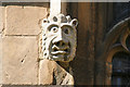
Early Medieval (Dark Age)Site Name: Southwell MinsterCountry: England County: Nottinghamshire Type: Early Christian Sculptured Stone
Nearest Town: Southwell
Map Ref: SK70165378
Latitude: 53.076650N Longitude: 0.954169W
Condition:
| 5 | Perfect |
| 4 | Almost Perfect |
| 3 | Reasonable but with some damage |
| 2 | Ruined but still recognisable as an ancient site |
| 1 | Pretty much destroyed, possibly visible as crop marks |
| 0 | No data. |
| -1 | Completely destroyed |
| 5 | Superb |
| 4 | Good |
| 3 | Ordinary |
| 2 | Not Good |
| 1 | Awful |
| 0 | No data. |
| 5 | Can be driven to, probably with disabled access |
| 4 | Short walk on a footpath |
| 3 | Requiring a bit more of a walk |
| 2 | A long walk |
| 1 | In the middle of nowhere, a nightmare to find |
| 0 | No data. |
| 5 | co-ordinates taken by GPS or official recorded co-ordinates |
| 4 | co-ordinates scaled from a detailed map |
| 3 | co-ordinates scaled from a bad map |
| 2 | co-ordinates of the nearest village |
| 1 | co-ordinates of the nearest town |
| 0 | no data |
Internal Links:
External Links:
I have visited· I would like to visit
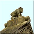
Anne T visited on 20th Sep 2015 - their rating: Cond: 3 Amb: 4 Access: 5 10th/11th century tympanum, Southwell Minster, Nottinghamshire: On our way back from Grantham we took a short detour to Southwell. What a stunning little town, with a huge Minster. At the time of our visit there were two services running almost back to back, so we didn't get to see some of the early carved capitals. The tympanum on the western wall of the north transept more than made up for it, with its 11th century carving of St. Michael and the dragon facing us, then underneath (on the narrower face) was the remains of a 10th century Saxon grave cover. The light streamed through the window above, making it difficult to photograph well. I was astonished to find a photograph licence was £5! However, the greeter said as the verger was in the service, unless I was very obvious with my camera, we wouldn't be charged unless the verger spotted us! It was very late on Sunday afternoon at the time of our visit so the museum/café area wasn't open. It would be nice to go back at a time when services aren't on so we could see the quire, chancel and sanctuary and have a wander round at our leisure, but it's unlikely that we'll get back to Nottinghamshire any time soon.
Orcinus have visited here
")
The Visitor Guides to Southwell Minster inform us that it was founded by the Saxons and rebuilt in Norman times. In medieval times it was declared by the then Archbishop of York to be the ‘mother church’ for the county of Nottinghamshire and has been a place of pilgrimage for almost 1,000 years. The Minster is large for the size of the town and has been described as "Nottinghamshire's most loved building". Adjacent to the Minster are the ruins of the Archbishop's Palace.
There is one carved stone, located in the west wall of the North Transept, which is said to come from the original Saxon building. The Visitor's Companion (page 22) describes "this ancient lintel or tympanum may have been part of the Saxon Minster and is dated between the 9th and 11th century. The carving of St. Michael warding off a dragon is thought to date from 1100 but the carving on the underside may be part of a 10th century grave slab."
The Minster sits alongside the A612 which is wide at this point, with ample parking just outside the Minster. There are a number of services throughout the day so access to the quire, chancel and sanctuary may be limited depending on the time of your visit. At the time of writing "A Visitor's Companion" guide book was available to purchase at £3 and a licence to take photographs cost £5.
You may be viewing yesterday's version of this page. To see the most up to date information please register for a free account.
")
Do not use the above information on other web sites or publications without permission of the contributor.
Nearby Images from Geograph Britain and Ireland:
©2008(licence)
©2017(licence)
©2021(licence)

©2008(licence)
©2021(licence)
The above images may not be of the site on this page, they are loaded from Geograph.
Please Submit an Image of this site or go out and take one for us!
Click here to see more info for this site
Nearby sites
Key: Red: member's photo, Blue: 3rd party photo, Yellow: other image, Green: no photo - please go there and take one, Grey: site destroyed
Download sites to:
KML (Google Earth)
GPX (GPS waypoints)
CSV (Garmin/Navman)
CSV (Excel)
To unlock full downloads you need to sign up as a Contributory Member. Otherwise downloads are limited to 50 sites.
Turn off the page maps and other distractions
Nearby sites listing. In the following links * = Image available
1.7km WSW 253° St Catherine's Well (Westthorpe)* Holy Well or Sacred Spring (SK68565327)
4.2km ESE 109° Rolleston Cross* Ancient Cross (SK7418052489)
4.2km ESE 108° Holy Trinity (Rolleston)* Ancient Cross (SK7418552503)
6.0km W 277° Hart's Well* Holy Well or Sacred Spring (SK6415254451)
6.7km W 266° Oldox Camp* Hillfort (SK635532)
7.1km WNW 282° Combs Camp Hillfort (SK63145512)
8.8km SE 139° Willow Rundle Spring* Holy Well or Sacred Spring (SK7602047230)
9.3km E 97° Farndon Fields* Natural Stone / Erratic / Other Natural Feature (SK794528)
9.9km WSW 241° King's Well (Calverton) Holy Well or Sacred Spring (SK615489)
10.1km ESE 116° Hawton Cursus Cursus (SK79294949)
11.2km SW 221° The Lambley Spring* Holy Well or Sacred Spring (SK629452)
11.4km SW 217° Burton Lodge Fort Hillfort (SK63364461)
11.7km W 281° Ashwell (Blidworth) Holy Well or Sacred Spring (SK586558)
11.8km WSW 244° Cockpit Hill Hillfort (SK59584850)
12.1km S 183° Shelford and Newton Cursus Cursus (SK696417)
12.3km S 183° Old Wark Spring* Holy Well or Sacred Spring (SK698415)
12.6km W 281° The Druid Stone (Blidworth)* Natural Stone / Erratic / Other Natural Feature (SK577560)
13.1km N 11° The Duck's Mouth* Holy Well or Sacred Spring (SK724667)
13.7km WNW 284° Friar Tuck's Well* Holy Well or Sacred Spring (SK568569)
13.9km ENE 71° Langford, Brough and Glebe Farm sites on the A46* Ancient Village or Settlement (SK833584)
15.9km W 271° St Mary's Well (Newstead)* Holy Well or Sacred Spring (SK542537)
16.1km NE 51° Besthorpe Ancient Village or Settlement (SK825641)
16.3km SW 224° St Ann's Well (Nottingham) Holy Well or Sacred Spring (SK58914191)
16.5km N 11° Holy well ( Tuxford ) Holy Well or Sacred Spring (SK7370)
17.0km S 191° Stragglethorpe Bronze Age ring ditch* Round Barrow(s) (SK6720037057)
View more nearby sites and additional images


 We would like to know more about this location. Please feel free to add a brief description and any relevant information in your own language.
 Wir möchten mehr über diese Stätte erfahren. Bitte zögern Sie nicht, eine kurze Beschreibung und relevante Informationen in Deutsch hinzuzufügen.
 Nous aimerions en savoir encore un peu sur les lieux. S'il vous plaît n'hesitez pas à ajouter une courte description et tous les renseignements pertinents dans votre propre langue.
 Quisieramos informarnos un poco más de las lugares. No dude en añadir una breve descripción y otros datos relevantes en su propio idioma.