

<< Our Photo Pages >> Cudbury Clump Barrow - Round Barrow(s) in England in Hampshire
Submitted by coldrum on Thursday, 30 June 2011 Page Views: 4415
Neolithic and Bronze AgeSite Name: Cudbury Clump BarrowCountry: England
NOTE: This site is 4.72 km away from the location you searched for.
County: Hampshire Type: Round Barrow(s)
Nearest Town: Yateley
Map Ref: SU76216058
Latitude: 51.339210N Longitude: 0.907324W
Condition:
| 5 | Perfect |
| 4 | Almost Perfect |
| 3 | Reasonable but with some damage |
| 2 | Ruined but still recognisable as an ancient site |
| 1 | Pretty much destroyed, possibly visible as crop marks |
| 0 | No data. |
| -1 | Completely destroyed |
| 5 | Superb |
| 4 | Good |
| 3 | Ordinary |
| 2 | Not Good |
| 1 | Awful |
| 0 | No data. |
| 5 | Can be driven to, probably with disabled access |
| 4 | Short walk on a footpath |
| 3 | Requiring a bit more of a walk |
| 2 | A long walk |
| 1 | In the middle of nowhere, a nightmare to find |
| 0 | No data. |
| 5 | co-ordinates taken by GPS or official recorded co-ordinates |
| 4 | co-ordinates scaled from a detailed map |
| 3 | co-ordinates scaled from a bad map |
| 2 | co-ordinates of the nearest village |
| 1 | co-ordinates of the nearest town |
| 0 | no data |
Internal Links:
External Links:
")
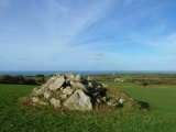
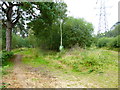
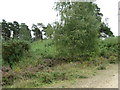
A bowl barrow, encroached upon and surrounded by a tree-ring. The barrow has an overall diameter of 26 metres, including the tree-ring, with a maximum height of 1.5 metres. There is no visible ditch. The mound is planted with firs and is in a plantation.
Source: Pastscape
You may be viewing yesterday's version of this page. To see the most up to date information please register for a free account.
")
Do not use the above information on other web sites or publications without permission of the contributor.
Nearby Images from Geograph Britain and Ireland:
©2014(licence)
©2014(licence)
©2011(licence)
©2014(licence)
©2009(licence)
The above images may not be of the site on this page, they are loaded from Geograph.
Please Submit an Image of this site or go out and take one for us!
Click here to see more info for this site
Nearby sites
Key: Red: member's photo, Blue: 3rd party photo, Yellow: other image, Green: no photo - please go there and take one, Grey: site destroyed
Download sites to:
KML (Google Earth)
GPX (GPS waypoints)
CSV (Garmin/Navman)
CSV (Excel)
To unlock full downloads you need to sign up as a Contributory Member. Otherwise downloads are limited to 50 sites.
Turn off the page maps and other distractions
Nearby sites listing. In the following links * = Image available
1.7km E 79° Eversley Church Sarsen Stone* Natural Stone / Erratic / Other Natural Feature (SU7791060924)
5.1km NE 38° Warren Lodge Barrows* Round Barrow(s) (SU7925664643)
6.6km ESE 106° Ancient field boundaries near Blackwater Misc. Earthwork (SU8257058911)
7.0km ESE 107° Hornley Common* Round Barrow(s) (SU8291758669)
7.1km ESE 105° Round Barrow near Blackwater Round Barrow(s) (SU8310158871)
9.4km WSW 257° Bullsdown Camp* Hillfort (SU67085838)
11.0km ENE 58° Woodenhill Plantation Barrow Round Barrow(s) (SU85496656)
11.1km SW 221° Mapledurwell Bowl Barrow* Round Barrow(s) (SU691521)
11.2km NNW 329° Reading Cursus* Cursus (SU70307005)
11.2km N 349° Whiteknights Stones* Modern Stone Circle etc (SU739715)
11.3km ENE 64° Caesar's Camp (Berkshire)* Hillfort (SU863657)
12.4km SE 138° Bat's Hogsty* Misc. Earthwork (SU84685152)
12.5km W 279° Calleva Atrebatum* Ancient Village or Settlement (SU638623)
12.5km NNW 327° Anslow's Cottages Trackway Ancient Trackway (SU6923470984)
12.6km WNW 292° Holden's Firs* Barrow Cemetery (SU64366506)
12.7km SSE 153° Heath Brow Barrows* Barrow Cemetery (SU82184937)
12.8km SE 146° Caesar's Camp (Hampshire)* Hillfort (SU835501)
12.8km SE 125° Barrow on Queen's Hotel roundabout* Round Barrow(s) (SU8682953432)
13.1km NE 55° Bill Hill (Berkshire)* Round Barrow(s) (SU868683)
13.7km NNW 341° Reading Museum* Museum (SU716735)
13.7km WNW 281° The Frith (Hampshire)* Hillfort (SU62686308)
14.0km WNW 296° Ufton Nervet Bell Barrow* Round Barrow(s) (SU6356266625)
14.4km W 280° Aldermaston Enclosure* Misc. Earthwork (SU6197062917)
14.4km WNW 294° Raven Hill* Promontory Fort / Cliff Castle (SU62876615)
14.5km NW 311° Burghfield Cursus Cursus (SU65137000)
View more nearby sites and additional images


 We would like to know more about this location. Please feel free to add a brief description and any relevant information in your own language.
 Wir möchten mehr über diese Stätte erfahren. Bitte zögern Sie nicht, eine kurze Beschreibung und relevante Informationen in Deutsch hinzuzufügen.
 Nous aimerions en savoir encore un peu sur les lieux. S'il vous plaît n'hesitez pas à ajouter une courte description et tous les renseignements pertinents dans votre propre langue.
 Quisieramos informarnos un poco más de las lugares. No dude en añadir una breve descripción y otros datos relevantes en su propio idioma.