


<< Our Photo Pages >> Chinnor Hill Barrows - Round Barrow(s) in England in Oxfordshire
Submitted by coldrum on Tuesday, 31 August 2010 Page Views: 9015
Neolithic and Bronze AgeSite Name: Chinnor Hill BarrowsCountry: England
NOTE: This site is 1.433 km away from the location you searched for.
County: Oxfordshire Type: Round Barrow(s)
Nearest Village: Chinnor
Map Ref: SP76760063
Latitude: 51.699176N Longitude: 0.890719W
Condition:
| 5 | Perfect |
| 4 | Almost Perfect |
| 3 | Reasonable but with some damage |
| 2 | Ruined but still recognisable as an ancient site |
| 1 | Pretty much destroyed, possibly visible as crop marks |
| 0 | No data. |
| -1 | Completely destroyed |
| 5 | Superb |
| 4 | Good |
| 3 | Ordinary |
| 2 | Not Good |
| 1 | Awful |
| 0 | No data. |
| 5 | Can be driven to, probably with disabled access |
| 4 | Short walk on a footpath |
| 3 | Requiring a bit more of a walk |
| 2 | A long walk |
| 1 | In the middle of nowhere, a nightmare to find |
| 0 | No data. |
| 5 | co-ordinates taken by GPS or official recorded co-ordinates |
| 4 | co-ordinates scaled from a detailed map |
| 3 | co-ordinates scaled from a bad map |
| 2 | co-ordinates of the nearest village |
| 1 | co-ordinates of the nearest town |
| 0 | no data |
Be the first person to rate this site - see the 'Contribute!' box in the right hand menu.
Internal Links:
External Links:
I have visited· I would like to visit
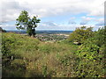
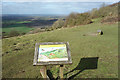
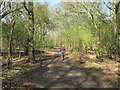
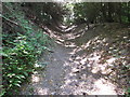
Richard13 visited on 19th Aug 2023 - their rating: Cond: 3 Amb: 5 Access: 4 The Chinnor Hill barrows are recognisable but are covered in vegetation so could be missed at first. However there is a sign to show their location, and once found the nature and layout of the site becomes clear. Situated on top of the Chiltern escarpment in the heart of nature reserve this site has a beautiful and spectacular location, with fine views available of the surrounding landscape and the local flora and fauna. It is a short walk on a good path from the nature reserve car park.
")
From Pastscape:
"The monument includes two bowl barrows situated on Chinnor Hill. The barrow lies on a north west facing slope, overlooking the Upper Icknield Way and the Lower Icknield Way, between Chinnor and Bledlow. The pair of barrows both have central mounds measuring between 23 metres and 24 metres in diameter. They both stand up to 1.2 metres high. The barrow mounds are surrounded by partly infilled quarry ditches which run together, forming a figure of eight in plan. These measure circa 1.5 metres wide and are visible as a low depression circa 0.3 metres deep. A labourer digging on the two barrows in 1899 found a secondary Anglo-Saxon inhumation burial. This had been cut into the mound and was accompanied by spearheads and a bronze chape. The burial probably belonged to a small settlement, situated between and to the north of the pair of barrows. Scheduled."
Read More at Pastscape.
You may be viewing yesterday's version of this page. To see the most up to date information please register for a free account.
")
")
Do not use the above information on other web sites or publications without permission of the contributor.
Nearby Images from Geograph Britain and Ireland:
©2015(licence)
©2018(licence)
©2010(licence)
©2015(licence)
©2022(licence)
The above images may not be of the site on this page, they are loaded from Geograph.
Please Submit an Image of this site or go out and take one for us!
Click here to see more info for this site
Nearby sites
Key: Red: member's photo, Blue: 3rd party photo, Yellow: other image, Green: no photo - please go there and take one, Grey: site destroyed
Download sites to:
KML (Google Earth)
GPX (GPS waypoints)
CSV (Garmin/Navman)
CSV (Excel)
To unlock full downloads you need to sign up as a Contributory Member. Otherwise downloads are limited to 50 sites.
Turn off the page maps and other distractions
Nearby sites listing. In the following links * = Image available
715m NE 50° The Cop (Chinnor) Round Barrow(s) (SP773011)
1.9km NE 34° The Lyde Spring* Holy Well or Sacred Spring (SP778022)
2.1km E 97° Lodge Hill Barrows Round Barrow(s) (SP78840041)
2.7km ESE 104° Lodge Hill Round Barrow(s) (SP79400004)
2.8km ESE 106° Lodge Hill Settlement Ancient Village or Settlement (SU79479990)
5.0km ENE 58° Princes Risborough Puddingstone* Natural Stone / Erratic / Other Natural Feature (SP80970338)
5.4km ESE 118° Smalldean Round Barrow(s) (SU816982)
6.4km ENE 59° Whiteleaf Barrows* Long Barrow (SP82220398)
7.0km ESE 111° Chilterns Grims Ditch* Misc. Earthwork (SU833982)
7.0km ESE 121° Bradenham Puddingstone* Natural Stone / Erratic / Other Natural Feature (SU828971)
7.8km ENE 57° Pulpit Hill* Hillfort (SP832050)
7.8km SE 134° Church Hill Trackway Ancient Trackway (SU82469533)
7.9km SE 134° Celtic field system on Church Hill Misc. Earthwork (SU82559530)
8.0km NE 49° Ragpit Cross Dykes Misc. Earthwork (SP82750600)
8.0km NE 49° Ragpit Hill Cross Dyke Misc. Earthwork (SP82750601)
8.2km NE 50° Ragpit Cross Dyke Misc. Earthwork (SP83020598)
8.2km SE 134° West Wycombe Camp* Hillfort (SU82769499)
8.4km SE 135° Church Hill Celtic Fields Misc. Earthwork (SU82809480)
9.0km E 96° Denner Hill Puddingstone Natural Stone / Erratic / Other Natural Feature (SU857998)
9.0km E 82° Grim's Ditch Barrows Round Barrow(s) (SP857020)
9.8km E 92° Stonygreen Puddingstone Natural Stone / Erratic / Other Natural Feature (SP866005)
10.3km NNW 345° Cuddington Spring Holy Well or Sacred Spring (SP739105)
10.8km SE 134° Desborough Castle* Hillfort (SU847933)
10.9km NNW 334° Stock Well (Chearsley)* Holy Well or Sacred Spring (SP718103)
11.4km NE 56° Bacombe Hill Bowl Barrow Round Barrow(s) (SP86130709)
View more nearby sites and additional images


 We would like to know more about this location. Please feel free to add a brief description and any relevant information in your own language.
 Wir möchten mehr über diese Stätte erfahren. Bitte zögern Sie nicht, eine kurze Beschreibung und relevante Informationen in Deutsch hinzuzufügen.
 Nous aimerions en savoir encore un peu sur les lieux. S'il vous plaît n'hesitez pas à ajouter une courte description et tous les renseignements pertinents dans votre propre langue.
 Quisieramos informarnos un poco más de las lugares. No dude en añadir una breve descripción y otros datos relevantes en su propio idioma.