


<< Other Photo Pages >> Ryedale Folk Museum - Museum in England in Yorkshire (North)
Submitted by TimPrevett on Thursday, 03 April 2008 Page Views: 6677
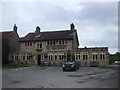
MuseumsSite Name: Ryedale Folk MuseumCountry: England County: Yorkshire (North) Type: Museum
Nearest Town: Hutton Le Hole
Map Ref: SE7051890022
Latitude: 54.300950N Longitude: 0.917886W
Condition:
| 5 | Perfect |
| 4 | Almost Perfect |
| 3 | Reasonable but with some damage |
| 2 | Ruined but still recognisable as an ancient site |
| 1 | Pretty much destroyed, possibly visible as crop marks |
| 0 | No data. |
| -1 | Completely destroyed |
| 5 | Superb |
| 4 | Good |
| 3 | Ordinary |
| 2 | Not Good |
| 1 | Awful |
| 0 | No data. |
| 5 | Can be driven to, probably with disabled access |
| 4 | Short walk on a footpath |
| 3 | Requiring a bit more of a walk |
| 2 | A long walk |
| 1 | In the middle of nowhere, a nightmare to find |
| 0 | No data. |
| 5 | co-ordinates taken by GPS or official recorded co-ordinates |
| 4 | co-ordinates scaled from a detailed map |
| 3 | co-ordinates scaled from a bad map |
| 2 | co-ordinates of the nearest village |
| 1 | co-ordinates of the nearest town |
| 0 | no data |
Internal Links:
External Links:
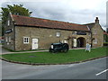
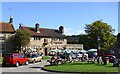
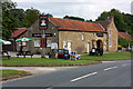
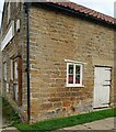
Open Air Museum in North Yorkshire. Take a walk through the site and learn about the history of Ryedale from centuries past. Their collection includes some pre-Norman cross fragments.
Ryedale Folk Museum
Hutton le Hole
York
YO62 6UA
Tel: 01751 417 367
/www.ryedalefolkmuseum.co.uk
Note: New replica of Iron Age roundhouse announced
You may be viewing yesterday's version of this page. To see the most up to date information please register for a free account.
Do not use the above information on other web sites or publications without permission of the contributor.
kelpie has found this location on Google Street View:
Nearby Images from Geograph Britain and Ireland:
©2012(licence)
©2009(licence)
©2008(licence)
©2021(licence)
©2011(licence)
The above images may not be of the site on this page, they are loaded from Geograph.
Please Submit an Image of this site or go out and take one for us!
Click here to see more info for this site
Nearby sites
Key: Red: member's photo, Blue: 3rd party photo, Yellow: other image, Green: no photo - please go there and take one, Grey: site destroyed
Download sites to:
KML (Google Earth)
GPX (GPS waypoints)
CSV (Garmin/Navman)
CSV (Excel)
To unlock full downloads you need to sign up as a Contributory Member. Otherwise downloads are limited to 50 sites.
Turn off the page maps and other distractions
Nearby sites listing. In the following links * = Image available
1.7km ENE 78° Mary Magdalene's Well* Holy Well or Sacred Spring (SE722904)
1.8km NNW 340° Slap Stones Wath RC1* Round Cairn (SE6986791732)
2.0km NNW 328° Hangman Stone (Shortsha Beck)* Marker Stone (SE6941391740)
2.1km W 263° Kirk Howe Cairn (SE68458975)
2.3km E 80° St Mary (Lastingham)* Ancient Cross (SE72819045)
2.4km E 81° St Cedd's Well* Holy Well or Sacred Spring (SE7291990460)
2.5km NNW 336° Blakey Road South BS1* Marker Stone (SE6945792278)
2.5km E 79° St Chad's Well (Lastingham)* Holy Well or Sacred Spring (SE7296390542)
2.7km NNW 338° Thorn Stone (Blakey Ridge)* Marker Stone (SE6944592556)
2.8km N 3° High Snape's ring cairn* Ring Cairn (SE706928)
2.8km NNW 336° Blakey Ridge Guide Stone* Marker Stone (SE6936292558)
2.9km NNW 334° Lund Road Standing Stone* Standing Stone (Menhir) (SE6922992572)
3.2km NNW 332° Hagg End Cairnfield* Round Barrow(s) (SE6895692803)
3.2km ESE 118° High Cross (Appleton Le Moors)* Ancient Cross (SE7335888560)
3.4km ESE 123° Low Cross (Appleton Le Moors)* Ancient Cross (SE7342188200)
3.9km SW 220° Robin Hood's Howl Round Barrow(s) (SE68038695)
4.0km NW 311° Harland Moor* Stone Circle (SE675926)
4.3km NNE 28° Ana Cross Round Barrow and Wayside Cross* Round Barrow(s) (SE7247393823)
4.4km NE 37° Redman Cross* Ancient Cross (SE7315893568)
4.5km SSE 154° Sinnington Round Barrow* Round Barrow(s) (SE7255686032)
4.5km NE 50° Abrahams Hut (Spaunton Moor)* Round Cairn (SE7394093016)
4.8km E 80° Black Park* Standing Stone (Menhir) (SE753909)
4.9km NNE 14° Three Howes (Blakey)* Barrow Cemetery (SE71669475)
5.1km SW 215° Kirkdale Sundial* Early Christian Sculptured Stone (SE6768885776)
5.1km E 99° Cropton Cross* Ancient Cross (SE7562689277)
View more nearby sites and additional images


 We would like to know more about this location. Please feel free to add a brief description and any relevant information in your own language.
 Wir möchten mehr über diese Stätte erfahren. Bitte zögern Sie nicht, eine kurze Beschreibung und relevante Informationen in Deutsch hinzuzufügen.
 Nous aimerions en savoir encore un peu sur les lieux. S'il vous plaît n'hesitez pas à ajouter une courte description et tous les renseignements pertinents dans votre propre langue.
 Quisieramos informarnos un poco más de las lugares. No dude en añadir una breve descripción y otros datos relevantes en su propio idioma.