


<< Text Pages >> Church Hill Trackway - Ancient Trackway in England in Buckinghamshire
Submitted by coldrum on Wednesday, 01 September 2010 Page Views: 3517
Multi-periodSite Name: Church Hill TrackwayCountry: England
NOTE: This site is 3.952 km away from the location you searched for.
County: Buckinghamshire Type: Ancient Trackway
Map Ref: SU82469533
Latitude: 51.650726N Longitude: 0.809511W
Condition:
| 5 | Perfect |
| 4 | Almost Perfect |
| 3 | Reasonable but with some damage |
| 2 | Ruined but still recognisable as an ancient site |
| 1 | Pretty much destroyed, possibly visible as crop marks |
| 0 | No data. |
| -1 | Completely destroyed |
| 5 | Superb |
| 4 | Good |
| 3 | Ordinary |
| 2 | Not Good |
| 1 | Awful |
| 0 | No data. |
| 5 | Can be driven to, probably with disabled access |
| 4 | Short walk on a footpath |
| 3 | Requiring a bit more of a walk |
| 2 | A long walk |
| 1 | In the middle of nowhere, a nightmare to find |
| 0 | No data. |
| 5 | co-ordinates taken by GPS or official recorded co-ordinates |
| 4 | co-ordinates scaled from a detailed map |
| 3 | co-ordinates scaled from a bad map |
| 2 | co-ordinates of the nearest village |
| 1 | co-ordinates of the nearest town |
| 0 | no data |
Be the first person to rate this site - see the 'Contribute!' box in the right hand menu.
Internal Links:
External Links:
Ancient Trackway in Buckinghamshire
From Pastscape:
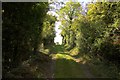
"Terraced trackway associated with a 'Celtic' field system on the south-western slopes of of Church Hill. The trackway, which follows the contour of the natural slope, runs parallel with the cultivation lynchets of the field system, defined on its uphill side by a well-preserved scarp 0.4m in height. The trackway dog-legs at its mid-point, north-west of which it is also defined by a small scarp on the downhill side."
Source: Pastscape
You may be viewing yesterday's version of this page. To see the most up to date information please register for a free account.
Do not use the above information on other web sites or publications without permission of the contributor.
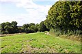
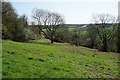
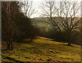
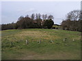
Nearby Images from Geograph Britain and Ireland:
©2009(licence)
©2018(licence)
©2012(licence)
©2008(licence)
©2009(licence)
The above images may not be of the site on this page, they are loaded from Geograph.
Please Submit an Image of this site or go out and take one for us!
Click here to see more info for this site
Nearby sites
Key: Red: member's photo, Blue: 3rd party photo, Yellow: other image, Green: no photo - please go there and take one, Grey: site destroyed
Download sites to:
KML (Google Earth)
GPX (GPS waypoints)
CSV (Garmin/Navman)
CSV (Excel)
To unlock full downloads you need to sign up as a Contributory Member. Otherwise downloads are limited to 50 sites.
Turn off the page maps and other distractions
Nearby sites listing. In the following links * = Image available
95m ESE 109° Celtic field system on Church Hill Misc. Earthwork (SU82559530)
453m SE 140° West Wycombe Camp* Hillfort (SU82769499)
629m SSE 148° Church Hill Celtic Fields Misc. Earthwork (SU82809480)
1.8km NNE 12° Bradenham Puddingstone* Natural Stone / Erratic / Other Natural Feature (SU828971)
3.0km NNE 17° Chilterns Grims Ditch* Misc. Earthwork (SU833982)
3.0km NNW 344° Smalldean Round Barrow(s) (SU816982)
3.0km SE 133° Desborough Castle* Hillfort (SU847933)
5.5km NNW 328° Lodge Hill Settlement Ancient Village or Settlement (SU79479990)
5.5km NE 37° Denner Hill Puddingstone Natural Stone / Erratic / Other Natural Feature (SU857998)
5.6km NNW 328° Lodge Hill Round Barrow(s) (SP79400004)
5.9km SE 125° Keep Hill Hillfort (SU87379205)
6.2km NW 326° Lodge Hill Barrows Round Barrow(s) (SP78840041)
6.6km NE 40° Stonygreen Puddingstone Natural Stone / Erratic / Other Natural Feature (SP866005)
7.4km NNE 27° Grim's Ditch Barrows Round Barrow(s) (SP857020)
7.7km NW 319° The Cop (Chinnor) Round Barrow(s) (SP773011)
7.8km NW 314° Chinnor Hill Barrows* Round Barrow(s) (SP76760063)
8.2km N 350° Princes Risborough Puddingstone* Natural Stone / Erratic / Other Natural Feature (SP80970338)
8.3km NNW 327° The Lyde Spring* Holy Well or Sacred Spring (SP778022)
8.7km N 359° Whiteleaf Barrows* Long Barrow (SP82220398)
9.7km N 5° Pulpit Hill* Hillfort (SP832050)
10.2km SW 234° Stonor Park Puddingstones Natural Stone / Erratic / Other Natural Feature (SU74288919)
10.2km SW 234° Stonor Park* Stone Circle (SU74318913)
10.4km ENE 60° Great Missenden Puddingstone* Natural Stone / Erratic / Other Natural Feature (SP9142700686)
10.5km S 176° Low Grounds Farm Barrow Cemetery (SU834849)
10.7km N 4° Ragpit Cross Dyke Misc. Earthwork (SP83020598)
View more nearby sites and additional images


 We would like to know more about this location. Please feel free to add a brief description and any relevant information in your own language.
 Wir möchten mehr über diese Stätte erfahren. Bitte zögern Sie nicht, eine kurze Beschreibung und relevante Informationen in Deutsch hinzuzufügen.
 Nous aimerions en savoir encore un peu sur les lieux. S'il vous plaît n'hesitez pas à ajouter une courte description et tous les renseignements pertinents dans votre propre langue.
 Quisieramos informarnos un poco más de las lugares. No dude en añadir una breve descripción y otros datos relevantes en su propio idioma.