


<< Our Photo Pages >> Vord Hill 3 - Cairn in Scotland in Shetland
Submitted by h_fenton on Monday, 08 February 2016 Page Views: 1431
Neolithic and Bronze AgeSite Name: Vord Hill 3Country: Scotland County: Shetland Type: Cairn
Nearest Town: Lerwick Nearest Village: Fetlar
Map Ref: HU6225193504
Latitude: 60.620075N Longitude: 0.864423W
Condition:
| 5 | Perfect |
| 4 | Almost Perfect |
| 3 | Reasonable but with some damage |
| 2 | Ruined but still recognisable as an ancient site |
| 1 | Pretty much destroyed, possibly visible as crop marks |
| 0 | No data. |
| -1 | Completely destroyed |
| 5 | Superb |
| 4 | Good |
| 3 | Ordinary |
| 2 | Not Good |
| 1 | Awful |
| 0 | No data. |
| 5 | Can be driven to, probably with disabled access |
| 4 | Short walk on a footpath |
| 3 | Requiring a bit more of a walk |
| 2 | A long walk |
| 1 | In the middle of nowhere, a nightmare to find |
| 0 | No data. |
| 5 | co-ordinates taken by GPS or official recorded co-ordinates |
| 4 | co-ordinates scaled from a detailed map |
| 3 | co-ordinates scaled from a bad map |
| 2 | co-ordinates of the nearest village |
| 1 | co-ordinates of the nearest town |
| 0 | no data |
Be the first person to rate this site - see the 'Contribute!' box in the right hand menu.
Internal Links:
External Links:
")
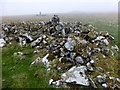
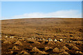
Small cairn, heel shaped, east of the trig point, close to the highest point of the hill.
The nearby trig point sits on a small pile of stones, possibly a cairn or stones robbed from Vord Hill 3.
You may be viewing yesterday's version of this page. To see the most up to date information please register for a free account.
")
Do not use the above information on other web sites or publications without permission of the contributor.
Nearby Images from Geograph Britain and Ireland:
©2013(licence)
©2022(licence)
©2015(licence)
©2015(licence)
©2015(licence)
The above images may not be of the site on this page, they are loaded from Geograph.
Please Submit an Image of this site or go out and take one for us!
Click here to see more info for this site
Nearby sites
Key: Red: member's photo, Blue: 3rd party photo, Yellow: other image, Green: no photo - please go there and take one, Grey: site destroyed
Download sites to:
KML (Google Earth)
GPX (GPS waypoints)
CSV (Garmin/Navman)
CSV (Excel)
To unlock full downloads you need to sign up as a Contributory Member. Otherwise downloads are limited to 50 sites.
Turn off the page maps and other distractions
Nearby sites listing. In the following links * = Image available
90m NW 304° Vord Hill South* Chambered Cairn (HU6217593553)
168m N 351° Vord Hill North* Chambered Cairn (HU6222193670)
725m SW 221° Whilsa Pund* Ancient Village or Settlement (HU61789295)
931m SSW 210° Fidlers Crus* Stone Circle (HU6179592690)
1.1km S 183° Hjaltadans* Stone Circle (HU6220892397)
1.2km SW 234° Stackaberg Cairn* Cairn (HU6128692786)
3.1km S 173° Ripple Stone (Fetlar) Standing Stone (Menhir) (HU62699044)
3.2km S 186° Houbie Broch* Broch or Nuraghe (HU61969035)
3.5km S 169° Feal Broch* Broch or Nuraghe (HU62959011)
4.2km SSE 154° Aithbank* Promontory Fort / Cliff Castle (HU6417589735)
4.3km W 259° Brough Lodge Broch* Broch or Nuraghe (HU5806392653)
4.4km W 269° Sna Broch* Broch or Nuraghe (HU5779393326)
6.2km S 187° Ruir Taing Broch or Nuraghe (HU616873)
6.4km NNW 340° Uyea Cairn* Cairn (HU599995)
6.9km WNW 290° Burra Ness broch* Broch or Nuraghe (HU55729569)
7.3km NNW 347° Clivocast Standing Stone* Standing Stones (HP60440055)
7.4km NNW 348° Uyea Breck* Standing Stone (Menhir) (HP60610071)
8.7km N 358° Sand Wick Burial Ground* Ancient Village or Settlement (HP6185102202)
9.1km NNW 341° Gletna W* Stone Circle (HP59160206)
9.6km NW 318° Hoga Ness broch* Broch or Nuraghe (HP557005)
10.2km NW 325° Ness of Wadbister Broch or Nuraghe (HP56200180)
10.7km NNW 330° Snabrough broch* Broch or Nuraghe (HP568027)
10.7km NNW 337° Lund Stone* Standing Stone (Menhir) (HP57870334)
10.9km NNW 343° Gunnister Stone* Carving (HP58840391)
11.3km NNW 341° Gunnister Standing Stone Standing Stone (Menhir) (HP5841704120)
View more nearby sites and additional images


 We would like to know more about this location. Please feel free to add a brief description and any relevant information in your own language.
 Wir möchten mehr über diese Stätte erfahren. Bitte zögern Sie nicht, eine kurze Beschreibung und relevante Informationen in Deutsch hinzuzufügen.
 Nous aimerions en savoir encore un peu sur les lieux. S'il vous plaît n'hesitez pas à ajouter une courte description et tous les renseignements pertinents dans votre propre langue.
 Quisieramos informarnos un poco más de las lugares. No dude en añadir una breve descripción y otros datos relevantes en su propio idioma.