 with our Megalithic Portal iPhone app")


<< Our Photo Pages >> Great Easton Roman Well - Holy Well or Sacred Spring in England in Leicestershire and Rutland
Submitted by enkidu41 on Tuesday, 31 August 2004 Page Views: 9012
Springs and Holy WellsSite Name: Great Easton Roman WellCountry: England
NOTE: This site is 3.37 km away from the location you searched for.
County: Leicestershire and Rutland Type: Holy Well or Sacred Spring
Nearest Town: Corby Nearest Village: Great Easton
Map Ref: SP850933
Latitude: 52.530946N Longitude: 0.748409W
Condition:
| 5 | Perfect |
| 4 | Almost Perfect |
| 3 | Reasonable but with some damage |
| 2 | Ruined but still recognisable as an ancient site |
| 1 | Pretty much destroyed, possibly visible as crop marks |
| 0 | No data. |
| -1 | Completely destroyed |
| 5 | Superb |
| 4 | Good |
| 3 | Ordinary |
| 2 | Not Good |
| 1 | Awful |
| 0 | No data. |
| 5 | Can be driven to, probably with disabled access |
| 4 | Short walk on a footpath |
| 3 | Requiring a bit more of a walk |
| 2 | A long walk |
| 1 | In the middle of nowhere, a nightmare to find |
| 0 | No data. |
| 5 | co-ordinates taken by GPS or official recorded co-ordinates |
| 4 | co-ordinates scaled from a detailed map |
| 3 | co-ordinates scaled from a bad map |
| 2 | co-ordinates of the nearest village |
| 1 | co-ordinates of the nearest town |
| 0 | no data |
Be the first person to rate this site - see the 'Contribute!' box in the right hand menu.
Internal Links:
External Links:
")
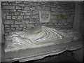
The so-called Roman Well stands in a field by Rectory Farm.
This imposing but curious structure is surmounted with what appears to be a cross base and shaft fragment . It has been dry for many years but the remains of a ditch runs from the well down the field.
Although the well is certainly not Roman, a Roman settlement was discovered to the south-west of the church.
Based on the description by, and used by kind permission of, Bob Trubshaw, from his Interactive Little-known Leicestershire and Rutland CD-ROM.
You may be viewing yesterday's version of this page. To see the most up to date information please register for a free account.
Do not use the above information on other web sites or publications without permission of the contributor.
Nearby Images from Geograph Britain and Ireland:
©2010(licence)
©2010(licence)
©2010(licence)
©2010(licence)
©2010(licence)
The above images may not be of the site on this page, they are loaded from Geograph.
Please Submit an Image of this site or go out and take one for us!
Click here to see more info for this site
Nearby sites
Key: Red: member's photo, Blue: 3rd party photo, Yellow: other image, Green: no photo - please go there and take one, Grey: site destroyed
Download sites to:
KML (Google Earth)
GPX (GPS waypoints)
CSV (Garmin/Navman)
CSV (Excel)
To unlock full downloads you need to sign up as a Contributory Member. Otherwise downloads are limited to 50 sites.
Turn off the page maps and other distractions
Nearby sites listing. In the following links * = Image available
5.0km E 84° The Jo Stone* Natural Stone / Erratic / Other Natural Feature (SP8995293949)
5.2km SE 134° Parliament Stone* Natural Stone / Erratic / Other Natural Feature (SP888898)
9.4km N 359° Ridlington settlement Misc. Earthwork (SK846027)
10.6km NNE 26° The Old Maze* Turf Maze (SK8954902833)
12.5km WSW 243° Peter's Pence Stone* Standing Stone (Menhir) (SP740874)
12.9km W 278° King Charles's Well* Holy Well or Sacred Spring (SP722949)
13.0km WSW 243° Harborough Museum* Museum (SP7342087285)
13.3km W 273° St. Ann's Well* Holy Well or Sacred Spring (SP717938)
13.4km N 353° The Braunston Goddess* Sculptured Stone (SK8324606581)
13.7km WNW 302° St John The Baptist (Rolleston)* Ancient Cross (SK7326200402)
14.2km ENE 76° Blatherwycke stone cross Marker Stone (SP988969)
15.5km WNW 294° St Michael's Church (Illston On The Hill)* Ancient Cross (SP7066899287)
15.6km WSW 243° Judith's Stone.* Marker Stone (SP7120786000)
15.9km ENE 56° Tixover Grange Long Barrow (SK981023)
16.2km NW 307° Billesdon Cross* Ancient Cross (SK7191302822)
16.2km NE 44° Wytchley Warren (Edith Weston) Cairn (SK961052)
16.3km N 7° Our Lady's Well (Oakham)* Holy Well or Sacred Spring (SK866095)
16.3km N 7° Oakham Timber Circle Timber Circle (SK867095)
16.9km W 275° The Munt* Artificial Mound (SP6807294487)
17.6km WNW 295° King's Norton* Holy Well or Sacred Spring (SK6890100495)
17.9km N 1° Langham Lodge Long Barrow (SK850112)
18.2km NE 35° Sheela-Na-Gig (Empingham)* Sculptured Stone (SK951085)
20.0km WSW 255° Mowsley Stone* Standing Stone (Menhir) (SP657877)
20.3km NW 307° Ingarsby* Standing Stone (Menhir) (SK6857805373)
20.5km N 8° Ashwell Wishing Well* Holy Well or Sacred Spring (SK874137)
View more nearby sites and additional images


 We would like to know more about this location. Please feel free to add a brief description and any relevant information in your own language.
 Wir möchten mehr über diese Stätte erfahren. Bitte zögern Sie nicht, eine kurze Beschreibung und relevante Informationen in Deutsch hinzuzufügen.
 Nous aimerions en savoir encore un peu sur les lieux. S'il vous plaît n'hesitez pas à ajouter une courte description et tous les renseignements pertinents dans votre propre langue.
 Quisieramos informarnos un poco más de las lugares. No dude en añadir una breve descripción y otros datos relevantes en su propio idioma.