 with our Megalithic Portal iPhone app")


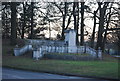
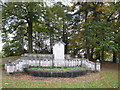
<< Other Photo Pages >> Barrow on Queen's Hotel roundabout - Round Barrow(s) in England in Hampshire
Submitted by Storm_oak on Monday, 25 November 2013 Page Views: 5755
Neolithic and Bronze AgeSite Name: Barrow on Queen's Hotel roundaboutCountry: England County: Hampshire Type: Round Barrow(s)
Nearest Town: Farnborough
Map Ref: SU8682953432
Latitude: 51.273431N Longitude: 0.756653W
Condition:
| 5 | Perfect |
| 4 | Almost Perfect |
| 3 | Reasonable but with some damage |
| 2 | Ruined but still recognisable as an ancient site |
| 1 | Pretty much destroyed, possibly visible as crop marks |
| 0 | No data. |
| -1 | Completely destroyed |
| 5 | Superb |
| 4 | Good |
| 3 | Ordinary |
| 2 | Not Good |
| 1 | Awful |
| 0 | No data. |
| 5 | Can be driven to, probably with disabled access |
| 4 | Short walk on a footpath |
| 3 | Requiring a bit more of a walk |
| 2 | A long walk |
| 1 | In the middle of nowhere, a nightmare to find |
| 0 | No data. |
| 5 | co-ordinates taken by GPS or official recorded co-ordinates |
| 4 | co-ordinates scaled from a detailed map |
| 3 | co-ordinates scaled from a bad map |
| 2 | co-ordinates of the nearest village |
| 1 | co-ordinates of the nearest town |
| 0 | no data |
Internal Links:
External Links:
")
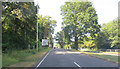
At quiet times of day it is possible to cross the road and walk to the barrow on the roundabout.
Drive along Farnborough Road travelling from Farnborough to Aldershot. You will see a large hotel on your left next to the roundabout with the barrow. It is best to go round the roundabout and back down the Farnborough road to find a quiet side street to park in.
You may be viewing yesterday's version of this page. To see the most up to date information please register for a free account.
Do not use the above information on other web sites or publications without permission of the contributor.
Nearby Images from Geograph Britain and Ireland:
©2012(licence)
©2012(licence)
©2012(licence)
©2012(licence)
©2014(licence)
The above images may not be of the site on this page, they are loaded from Geograph.
Please Submit an Image of this site or go out and take one for us!
Click here to see more info for this site
Nearby sites
Key: Red: member's photo, Blue: 3rd party photo, Yellow: other image, Green: no photo - please go there and take one, Grey: site destroyed
Download sites to:
KML (Google Earth)
GPX (GPS waypoints)
CSV (Garmin/Navman)
CSV (Excel)
To unlock full downloads you need to sign up as a Contributory Member. Otherwise downloads are limited to 50 sites.
Turn off the page maps and other distractions
Nearby sites listing. In the following links * = Image available
2.9km SW 229° Bat's Hogsty* Misc. Earthwork (SU84685152)
4.7km SW 226° Caesar's Camp (Hampshire)* Hillfort (SU835501)
5.6km S 189° Badshot Lea* Long Barrow (SU86084793)
6.2km SW 230° Heath Brow Barrows* Barrow Cemetery (SU82184937)
6.5km NW 324° Hornley Common* Round Barrow(s) (SU8291758669)
6.6km NNW 327° Round Barrow near Blackwater Round Barrow(s) (SU8310158871)
6.9km NW 323° Ancient field boundaries near Blackwater Misc. Earthwork (SU8257058911)
7.3km S 176° Botany Hill Camp Hillfort (SU875462)
7.3km S 172° Soldier's Ring* Hillfort (SU880462)
7.7km S 180° St. Mary's Well (Compton)* Holy Well or Sacred Spring (SU870457)
7.9km SSE 148° Hillbury hillfort* Hillfort (SU911468)
8.2km SSE 164° Culverswell Barrow* Round Barrow(s) (SU892456)
8.3km ENE 77° Bullswater Common Barrows Barrow Cemetery (SU9487555356)
8.8km SSE 165° Crooksbury Common Barrows* Barrow Cemetery (SU893450)
9.4km SSE 168° Tilford Barrows Barrow Cemetery (SU889443)
10.1km NE 39° West End Common Barrows* Barrow Cemetery (SU931614)
10.4km NE 42° New England Barrow Round Barrow(s) (SU93616129)
10.6km NE 56° St John the Baptist's Well* Holy Well or Sacred Spring (SU956595)
11.6km NW 311° Eversley Church Sarsen Stone* Natural Stone / Erratic / Other Natural Feature (SU7791060924)
12.3km N 359° Caesar's Camp (Berkshire)* Hillfort (SU863657)
12.7km E 90° Whitmoor Common* Round Barrow(s) (SU996536)
12.8km NW 305° Cudbury Clump Barrow* Round Barrow(s) (SU76216058)
12.8km S 188° Frensham Common Barrows* Barrow Cemetery (SU85334070)
12.9km ESE 111° St. Edward's Well* Holy Well or Sacred Spring (SU9949)
13.2km N 355° Woodenhill Plantation Barrow Round Barrow(s) (SU85496656)
View more nearby sites and additional images


 We would like to know more about this location. Please feel free to add a brief description and any relevant information in your own language.
 Wir möchten mehr über diese Stätte erfahren. Bitte zögern Sie nicht, eine kurze Beschreibung und relevante Informationen in Deutsch hinzuzufügen.
 Nous aimerions en savoir encore un peu sur les lieux. S'il vous plaît n'hesitez pas à ajouter une courte description et tous les renseignements pertinents dans votre propre langue.
 Quisieramos informarnos un poco más de las lugares. No dude en añadir una breve descripción y otros datos relevantes en su propio idioma.