


<< Our Photo Pages >> Hinderwell Cross Head - Ancient Cross in England in Yorkshire (North)
Submitted by Anne T on Saturday, 07 March 2020 Page Views: 624
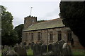
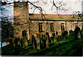
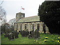
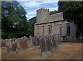
Early Medieval (Dark Age)Site Name: Hinderwell Cross Head Alternative Name: St Hilda's Church (Hinderwell)Country: England
NOTE: This site is 1.826 km away from the location you searched for.
County: Yorkshire (North) Type: Ancient Cross
Nearest Town: Whitby Nearest Village: Hinderwell
Map Ref: NZ7912217030
Latitude: 54.542359N Longitude: 0.77851W
Condition:
| 5 | Perfect |
| 4 | Almost Perfect |
| 3 | Reasonable but with some damage |
| 2 | Ruined but still recognisable as an ancient site |
| 1 | Pretty much destroyed, possibly visible as crop marks |
| 0 | No data. |
| -1 | Completely destroyed |
| 5 | Superb |
| 4 | Good |
| 3 | Ordinary |
| 2 | Not Good |
| 1 | Awful |
| 0 | No data. |
| 5 | Can be driven to, probably with disabled access |
| 4 | Short walk on a footpath |
| 3 | Requiring a bit more of a walk |
| 2 | A long walk |
| 1 | In the middle of nowhere, a nightmare to find |
| 0 | No data. |
| 5 | co-ordinates taken by GPS or official recorded co-ordinates |
| 4 | co-ordinates scaled from a detailed map |
| 3 | co-ordinates scaled from a bad map |
| 2 | co-ordinates of the nearest village |
| 1 | co-ordinates of the nearest town |
| 0 | no data |
Internal Links:
External Links:
I have visited· I would like to visit
Anne T visited on 4th Mar 2020 - their rating: Cond: 2 Amb: 3 Access: 4 The Hinderwell Cross Head, St Hilda's Church: Whilst the church itself is well kept and nicely presented, this cross head is tucked away in the foyer of the church, at the bottom of the stairwell leading to the gallery/organ.
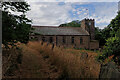
After photographing the well, we wandered up to the church, finding it open. Just inside, to the left hand side of the lobby, next to the stairs ascending to the gallery, was a cross head, which I photographed. Inside was a leaflet describing local heritage, and I found a short section about both Lythe and the Hinderwell Cross in there.
Just outside the south door, about 3m to the south west, is part of either a cross base or a column, which I also photographed.
Guy Points, in his Gazetteer of Anglo Saxon and Viking Sites: Yorkshire, only mentions the well (pages 161/162).
")
From St Hilda's Well in the churchyard, we wandered up to the church, pleasantly surprised to find it open. The Historic England List ID 1179349 entry for this church mentions the church contains "some pieces of Saxon carving, also a column or cross base". Pastscape Monument No. 1396812 tells us that the church was rebuilt in 1773 "on (a) mediaeval site with Saxon origins".
Inside the west porch, at the base of the staircase, I was surprised to see an old cross head propped against the base of the stairs leading up to the gallery/organ. I later found out this is recorded as AS Corpus Hinderwell 01 (St Hilda). This is a cross head of late-eleventh century date (date queried by the Corpus), which is "a is a plainer version of the type of cross-head found on the two round-headed grave-markers at Whitby Abbey …. and may be post-Conquest". The two broad faces are identical, showing a cross with solid plate-infill between the arms of the cross. It is thought to be a fragment of the original stone church.
A good look around the church resulted in no other Saxon fragments being found, although on first walking up to the church, I spotted what looked like part of a column base, about 3m to the south west of the western entrance, next to the steps leading down into the churchyard. The face away from the church shows some signs of very worn interlacing, indicating the stone may have been part of a cross. The shaping of this stone reminded me very much of the shape of the Maiden Cross, the western sanctuary cross for Hexham Priory, now located at the entrance to the car park for Hexham Hospital, as if the original cross had been re-shaped and re-purposed at some time in the distant past.
The Corpus of Anglo Saxon Stone Sculpture also records a fragment of a hogback stone, recorded by antiquarians, but now lost: see AS Corpus Hinderwell 02 (St Hilda).
You may be viewing yesterday's version of this page. To see the most up to date information please register for a free account.
")
")
")
")
Do not use the above information on other web sites or publications without permission of the contributor.
Nearby Images from Geograph Britain and Ireland:
©2018(licence)
©2022(licence)
©2020(licence)
©2013(licence)
©2022(licence)
The above images may not be of the site on this page, they are loaded from Geograph.
Please Submit an Image of this site or go out and take one for us!
Click here to see more info for this site
Nearby sites
Key: Red: member's photo, Blue: 3rd party photo, Yellow: other image, Green: no photo - please go there and take one, Grey: site destroyed
Download sites to:
KML (Google Earth)
GPX (GPS waypoints)
CSV (Garmin/Navman)
CSV (Excel)
To unlock full downloads you need to sign up as a Contributory Member. Otherwise downloads are limited to 50 sites.
Turn off the page maps and other distractions
Nearby sites listing. In the following links * = Image available
21m NNW 347° St Hilda's Well* Holy Well or Sacred Spring (NZ7911717050)
807m NNE 16° Hinderwell Beacon* Round Barrow(s) (NZ7933017811)
3.1km SSW 210° Newton Mulgrave Moor LB* Long Barrow (NZ7761214328)
3.3km SSW 194° Newton Mulgrave Moor RB3* Round Barrow(s) (NZ7836513815)
3.4km SSW 202° Newton Mulgrave Moor RB8* Round Barrow(s) (NZ7793213861)
3.4km S 191° Brown Higg Stone* Marker Stone (NZ7852013661)
3.6km SE 130° Claymore Well (Kettleness) Holy Well or Sacred Spring (NZ819148)
3.6km SSW 191° Newton Mulgrave Moor RB1* Round Barrow(s) (NZ7847913526)
3.8km S 191° Long Stone (Newton Mulgrave Woods)* Standing Stone (Menhir) (NZ7846113319)
3.8km WNW 294° Three Crosses Well (Boulby)* Holy Well or Sacred Spring (NZ7562218523)
4.1km ESE 119° Butter Howe* Round Barrow(s) (NZ82731513)
4.6km SE 125° Wades Stone (North)* Standing Stone (Menhir) (NZ8295414414)
4.8km WNW 283° Easington Cross* Ancient Cross (NZ7442718004)
5.5km WNW 291° Street House* Timber Circle (NZ739189)
5.6km SE 137° Wades Stone (South)* Standing Stone (Menhir) (NZ8305113007)
6.0km WNW 296° Street House Farm* Barrow Cemetery (NZ73651960)
6.6km S 188° High Park Farm (Ugthorpe Moor)* Round Barrow(s) (NZ7826210445)
6.8km S 190° Keld Bog (Ugthorpe Moor)* Round Barrow(s) (NZ7807410288)
6.9km S 184° Travellers Rest Farm* Marker Stone (NZ7872410107)
7.0km SE 124° St Oswald's Church (Lythe)* Ancient Cross (NZ8501613164)
7.1km SW 217° Nan Stone.* Marker Stone (NZ7498411279)
7.2km S 189° Ugthorpe Moor Pit Alignment and Round Barrows* Misc. Earthwork (NZ7814909913)
7.2km SW 216° Good Goose Thorne (East)* Marker Stone (NZ7497011089)
7.5km SW 217° Long Stone (Black Dike Moor)* Marker Stone (NZ7469210909)
7.7km SSW 207° Temple Beeld (Lealholm Moor)* Stone Row / Alignment (NZ7572810141)
View more nearby sites and additional images


 We would like to know more about this location. Please feel free to add a brief description and any relevant information in your own language.
 Wir möchten mehr über diese Stätte erfahren. Bitte zögern Sie nicht, eine kurze Beschreibung und relevante Informationen in Deutsch hinzuzufügen.
 Nous aimerions en savoir encore un peu sur les lieux. S'il vous plaît n'hesitez pas à ajouter une courte description et tous les renseignements pertinents dans votre propre langue.
 Quisieramos informarnos un poco más de las lugares. No dude en añadir una breve descripción y otros datos relevantes en su propio idioma.