


<< Our Photo Pages >> Boddington Camp - Hillfort in England in Buckinghamshire
Submitted by Andy B on Tuesday, 21 December 2010 Page Views: 22020
Iron Age and Later PrehistorySite Name: Boddington Camp Alternative Name: Boddington BanksCountry: England
NOTE: This site is 3.226 km away from the location you searched for.
County: Buckinghamshire Type: Hillfort
Nearest Town: Wendover Nearest Village: St Leonards
Map Ref: SP882080 Landranger Map Number: 165
Latitude: 51.763745N Longitude: 0.723364W
Condition:
| 5 | Perfect |
| 4 | Almost Perfect |
| 3 | Reasonable but with some damage |
| 2 | Ruined but still recognisable as an ancient site |
| 1 | Pretty much destroyed, possibly visible as crop marks |
| 0 | No data. |
| -1 | Completely destroyed |
| 5 | Superb |
| 4 | Good |
| 3 | Ordinary |
| 2 | Not Good |
| 1 | Awful |
| 0 | No data. |
| 5 | Can be driven to, probably with disabled access |
| 4 | Short walk on a footpath |
| 3 | Requiring a bit more of a walk |
| 2 | A long walk |
| 1 | In the middle of nowhere, a nightmare to find |
| 0 | No data. |
| 5 | co-ordinates taken by GPS or official recorded co-ordinates |
| 4 | co-ordinates scaled from a detailed map |
| 3 | co-ordinates scaled from a bad map |
| 2 | co-ordinates of the nearest village |
| 1 | co-ordinates of the nearest town |
| 0 | no data |
Internal Links:
External Links:
I have visited· I would like to visit
Andy B has visited here
")
The ramparts are covered mainly with scrub and brambles, with some mature trees: as a result there are few places where the bank and ditch are clearly visible. The outer slopes of the spur are also heavily wooded and although there are a few points from which one can catch a glimpse of Wendover below and the Vale beyond, there are no open views.
Note: Conservation volunteers help protect iron age hill fort, also the ambience of this area threatened by proposed high speed rail link
You may be viewing yesterday's version of this page. To see the most up to date information please register for a free account.
")
")
")
")
Do not use the above information on other web sites or publications without permission of the contributor.
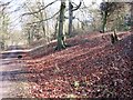
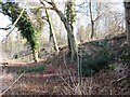
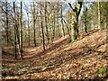
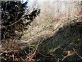
Nearby Images from Geograph Britain and Ireland:

©2009(licence)
©2009(licence)
©2009(licence)
©2009(licence)
©2009(licence)
The above images may not be of the site on this page, they are loaded from Geograph.
Please Submit an Image of this site or go out and take one for us!
Click here to see more info for this site
Nearby sites
Key: Red: member's photo, Blue: 3rd party photo, Yellow: other image, Green: no photo - please go there and take one, Grey: site destroyed
Download sites to:
KML (Google Earth)
GPX (GPS waypoints)
CSV (Garmin/Navman)
CSV (Excel)
To unlock full downloads you need to sign up as a Contributory Member. Otherwise downloads are limited to 50 sites.
Turn off the page maps and other distractions
Nearby sites listing. In the following links * = Image available
2.2km WSW 248° Bacombe Hill Barrow Cemetery (SP86160712)
2.3km WSW 247° Bacombe Hill Bowl Barrow Round Barrow(s) (SP86130709)
4.9km E 100° Cholesbury Camp* Hillfort (SP930072)
5.5km WSW 250° Ragpit Cross Dyke Misc. Earthwork (SP83020598)
5.8km WSW 251° Ragpit Hill Cross Dyke Misc. Earthwork (SP82750601)
5.8km WSW 251° Ragpit Cross Dykes Misc. Earthwork (SP82750600)
5.8km ENE 77° Grim’s Ditch (Hertfordshire) Misc. Earthwork (SP93850938)
5.8km WSW 240° Pulpit Hill* Hillfort (SP832050)
6.5km SSW 204° Grim's Ditch Barrows Round Barrow(s) (SP857020)
7.2km WSW 237° Whiteleaf Barrows* Long Barrow (SP82220398)
7.7km SSW 193° Stonygreen Puddingstone Natural Stone / Erratic / Other Natural Feature (SP866005)
8.0km SSE 157° Great Missenden Puddingstone* Natural Stone / Erratic / Other Natural Feature (SP9142700686)
8.5km NNW 328° St. Osyth's Well (Bierton)* Holy Well or Sacred Spring (SP836152)
8.6km WSW 238° Princes Risborough Puddingstone* Natural Stone / Erratic / Other Natural Feature (SP80970338)
8.6km SSW 198° Denner Hill Puddingstone Natural Stone / Erratic / Other Natural Feature (SU857998)
8.6km NE 54° Aldbury Nowers Round Barrow(s) (SP95071324)
8.8km NE 45° Northfield Settlement Ancient Village or Settlement (SP944143)
9.1km NE 48° Pitstone Hill Causewayed Enclosure (SP949142)
9.9km SE 132° St Mary's Church (Chesham)* Natural Stone / Erratic / Other Natural Feature (SP9566801521)
9.9km WNW 299° Hartwell Springs* Holy Well or Sacred Spring (SP7939412589)
10.2km ENE 61° Moneybury Hill Round Barrow(s) (SP97031309)
10.5km ENE 59° Moneybury Hill Bell Barrow* Round Barrow(s) (SP97111361)
10.9km SSW 208° Chilterns Grims Ditch* Misc. Earthwork (SU833982)
11.4km NE 44° Ivinghoe Beacon Hill Barrows* Barrow Cemetery (SP95961638)
11.6km ESE 121° Botley Puddingstones Natural Stone / Erratic / Other Natural Feature (SP983023)
View more nearby sites and additional images


 We would like to know more about this location. Please feel free to add a brief description and any relevant information in your own language.
 Wir möchten mehr über diese Stätte erfahren. Bitte zögern Sie nicht, eine kurze Beschreibung und relevante Informationen in Deutsch hinzuzufügen.
 Nous aimerions en savoir encore un peu sur les lieux. S'il vous plaît n'hesitez pas à ajouter une courte description et tous les renseignements pertinents dans votre propre langue.
 Quisieramos informarnos un poco más de las lugares. No dude en añadir una breve descripción y otros datos relevantes en su propio idioma.