


<< Text Pages >> Finedon Stone - Marker Stone in England in Northamptonshire
Submitted by DavidHoyle on Wednesday, 04 May 2022 Page Views: 739
Date UncertainSite Name: Finedon StoneCountry: England
NOTE: This site is 8.242 km away from the location you searched for.
County: Northamptonshire Type: Marker Stone
Nearest Town: Finedon
Map Ref: SP9161871928
Latitude: 52.337793N Longitude: 0.656731W
Condition:
| 5 | Perfect |
| 4 | Almost Perfect |
| 3 | Reasonable but with some damage |
| 2 | Ruined but still recognisable as an ancient site |
| 1 | Pretty much destroyed, possibly visible as crop marks |
| 0 | No data. |
| -1 | Completely destroyed |
| 5 | Superb |
| 4 | Good |
| 3 | Ordinary |
| 2 | Not Good |
| 1 | Awful |
| 0 | No data. |
| 5 | Can be driven to, probably with disabled access |
| 4 | Short walk on a footpath |
| 3 | Requiring a bit more of a walk |
| 2 | A long walk |
| 1 | In the middle of nowhere, a nightmare to find |
| 0 | No data. |
| 5 | co-ordinates taken by GPS or official recorded co-ordinates |
| 4 | co-ordinates scaled from a detailed map |
| 3 | co-ordinates scaled from a bad map |
| 2 | co-ordinates of the nearest village |
| 1 | co-ordinates of the nearest town |
| 0 | no data |
Internal Links:
External Links:
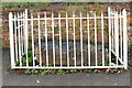
At the Finedon History Day in 2017, Jon-Paul Carr (Secretary of
the Northamptonshire Heritage Forum) was on the guided walk
round Finedon. He was interested in the stone behind the railings in Dolben Square. What is its importance? Francis Terry, leading the walk, quoted from John Bailey’s book “Finedon otherwise Thingdon “, p190 2nd para”: To all appearances, it is one of those stones set down in prehistoric times to mark a boundary or track and, if so, has been there for thousands of years…
Adjacent to the stone used to stand a public pump and there was at one time a similar, but smaller, stone which lay alongside the first. Jon-Paul suggested that it would be informative for locals and visitors to have a plaque on the railings explaining the stone’s significance. The Society successfully applied for a small community grant from Wellingborough Borough Council and, although there was some delay while the railings were painted, the plaque was erected earlier last year. The Society is very grateful for the Council’s financial support.
When you are next in Finedon, do go to Dolben square and have a look.
Source: Ancient Stone, Dolben Square by Rachel Terry in the Finedon Local History Society newsletter.
You may be viewing yesterday's version of this page. To see the most up to date information please register for a free account.
Do not use the above information on other web sites or publications without permission of the contributor.
Nearby Images from Geograph Britain and Ireland:
©2023(licence)

©2023(licence)
©2023(licence)
©2023(licence)
©2023(licence)
The above images may not be of the site on this page, they are loaded from Geograph.
Please Submit an Image of this site or go out and take one for us!
Click here to see more info for this site
Nearby sites
Key: Red: member's photo, Blue: 3rd party photo, Yellow: other image, Green: no photo - please go there and take one, Grey: site destroyed
Download sites to:
KML (Google Earth)
GPX (GPS waypoints)
CSV (Garmin/Navman)
CSV (Excel)
To unlock full downloads you need to sign up as a Contributory Member. Otherwise downloads are limited to 50 sites.
Turn off the page maps and other distractions
Nearby sites listing. In the following links * = Image available
4.7km E 84° Irthlingborough and Stanwick Barrows* Barrow Cemetery (SP963725)
5.0km ESE 102° Redlands Farm Long Barrow Long Barrow (SP965710)
5.1km E 96° Stanwick Lakes* Museum (SP96707150)
5.6km E 94° Raunds Ring Ditch Misc. Earthwork (SP972716)
6.0km E 86° West Cotton Monument Complex Long Barrow (SP97577248)
6.0km NE 49° Three Hills Barrows, Woodford* Barrow Cemetery (SP961760)
6.7km E 86° Cotton Henge* Henge (SP983725)
10.2km SW 230° Mears Ashby Tumulus* Misc. Earthwork (SP839653)
11.1km SSW 204° Grendon Cursus Cursus (SP87256174)
12.7km NE 53° Titchmarch Cursus Cursus (TL016798)
14.2km ESE 110° Harrowick, Upper Dean Natural Stone / Erratic / Other Natural Feature (TL0507267416)
15.3km SSE 167° Harrold Barrows* Barrow Cemetery (SP95245702)
15.8km SSE 147° Felmersham Cursus Cursus (TL004588)
16.3km WSW 248° St John's Well (Boughton)* Holy Well or Sacred Spring (SP765656)
16.5km WSW 248° Shepherd's Race (Boughton) Turf Maze (SP764655)
17.0km WSW 257° Longmans Hill Long Barrow* Long Barrow (SP751677)
17.9km WSW 251° Boughton bowl barrow* Round Barrow(s) (SP74706589)
18.1km N 352° Parliament Stone* Natural Stone / Erratic / Other Natural Feature (SP888898)
19.1km SSW 197° Holy Well (Olney)* Holy Well or Sacred Spring (SP864535)
19.4km SW 234° Becket's Well* Holy Well or Sacred Spring (SP761602)
19.7km SW 235° Northampton Museum and Art Gallery* Museum (SP7559260400)
19.7km SSE 159° Holywell (Bedfordshire)* Holy Well or Sacred Spring (SP9907753646)
19.8km S 174° Nell's Well* Holy Well or Sacred Spring (SP941523)
19.9km E 80° Seat of Judgement - Leighton Bromswold* Marker Stone (TL112756)
20.7km SE 127° Bolnhurst Earthwork Misc. Earthwork (TL084597)
View more nearby sites and additional images


 We would like to know more about this location. Please feel free to add a brief description and any relevant information in your own language.
 Wir möchten mehr über diese Stätte erfahren. Bitte zögern Sie nicht, eine kurze Beschreibung und relevante Informationen in Deutsch hinzuzufügen.
 Nous aimerions en savoir encore un peu sur les lieux. S'il vous plaît n'hesitez pas à ajouter une courte description et tous les renseignements pertinents dans votre propre langue.
 Quisieramos informarnos un poco más de las lugares. No dude en añadir una breve descripción y otros datos relevantes en su propio idioma.