

<< Our Photo Pages >> All Saints (Londesborough) - Ancient Cross in England in Yorkshire (East)
Submitted by Sunny100 on Wednesday, 28 March 2012 Page Views: 4417
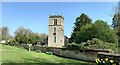
Early Medieval (Dark Age)Site Name: All Saints (Londesborough) Alternative Name: The Londesborough CrossCountry: England County: Yorkshire (East) Type: Ancient Cross
Nearest Town: Market Weighton Nearest Village: Londesborough
Map Ref: SE86864538
Latitude: 53.897324N Longitude: 0.679635W
Condition:
| 5 | Perfect |
| 4 | Almost Perfect |
| 3 | Reasonable but with some damage |
| 2 | Ruined but still recognisable as an ancient site |
| 1 | Pretty much destroyed, possibly visible as crop marks |
| 0 | No data. |
| -1 | Completely destroyed |
| 5 | Superb |
| 4 | Good |
| 3 | Ordinary |
| 2 | Not Good |
| 1 | Awful |
| 0 | No data. |
| 5 | Can be driven to, probably with disabled access |
| 4 | Short walk on a footpath |
| 3 | Requiring a bit more of a walk |
| 2 | A long walk |
| 1 | In the middle of nowhere, a nightmare to find |
| 0 | No data. |
| 5 | co-ordinates taken by GPS or official recorded co-ordinates |
| 4 | co-ordinates scaled from a detailed map |
| 3 | co-ordinates scaled from a bad map |
| 2 | co-ordinates of the nearest village |
| 1 | co-ordinates of the nearest town |
| 0 | no data |
Internal Links:
External Links:
 (PID:127976)")
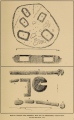
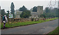
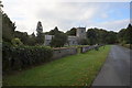
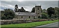
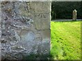
In All Saints Church at Londesborough is an Anglo/Danish cross-head and part of the shaft from a preaching cross. Although it is difficult to date these artefacts they are considered to be from the 9th-11th century.
These were excavated from close by the church, probably the churchyard, and the cross-head was built into the wall above the Norman doorway (south side). There are carvings on the piece of shaft and head that show distinct signs of both Saxon and Danish workmanship.
The church is said to be built on or close to the site of a pagan temple that belonged to Coifi the high priest but which was christianised by St Paulinus in 625 - at about the same time that he converted King Edwin of Northumbria. There was also a summer palace hereabouts belonging to the Saxon kings of Northumbria during the 6th and 7th century CE. When the local lake was drained back in 1895 a small section of Roman pavement was discovered; the village itself lies on the course of a Roman road.
You may be viewing yesterday's version of this page. To see the most up to date information please register for a free account.
Do not use the above information on other web sites or publications without permission of the contributor.
Nearby Images from Geograph Britain and Ireland:
©2008(licence)
©2016(licence)
©2020(licence)
©2022(licence)
©2022(licence)
The above images may not be of the site on this page, they are loaded from Geograph.
Please Submit an Image of this site or go out and take one for us!
Click here to see more info for this site
Nearby sites
Key: Red: member's photo, Blue: 3rd party photo, Yellow: other image, Green: no photo - please go there and take one, Grey: site destroyed
Download sites to:
KML (Google Earth)
GPX (GPS waypoints)
CSV (Garmin/Navman)
CSV (Excel)
To unlock full downloads you need to sign up as a Contributory Member. Otherwise downloads are limited to 50 sites.
Turn off the page maps and other distractions
Nearby sites listing. In the following links * = Image available
3.0km SE 143° Lady Well (Goodmanham)* Holy Well or Sacred Spring (SE887430)
3.2km NW 320° St James Church (Nunburnholme)* Ancient Cross (SE84774779)
3.7km SE 145° St Helen's Well (Goodmanham)* Holy Well or Sacred Spring (SE890424)
5.4km NW 324° Kilnwick Percy Hill - Barrow* Barrow Cemetery (SE8365149674)
6.1km NNW 335° Newcote Round Barrow* Barrow Cemetery (SE84225085)
7.2km N 4° Dearsden Hill Hillfort (SE872526)
7.4km SE 125° Arras Barrow Cemetery* Barrow Cemetery (SE930413)
9.8km WSW 240° Lady Well (Seaton Ross) Holy Well or Sacred Spring (SE784403)
11.4km SE 131° Littlewood Lodge Round Barrow(s) (SE95563801)
12.2km N 8° Fridaythorpe Earthworks* Misc. Earthwork (SE88425753)
12.5km NNW 339° Callis Wold Barrow Cemetery* Barrow Cemetery (SE8217857003)
12.6km SE 134° Ella Hill* Round Barrow(s) (SE9606036730)
12.7km SSE 150° St Austin's Stone (High Hunsley)* Natural Stone / Erratic / Other Natural Feature (SE9336034443)
13.0km S 170° St. Helen's Well (North Cave)* Holy Well or Sacred Spring (SE894326)
13.6km SE 136° Ling Howe Long Barrow Long Barrow (SE96503580)
13.6km ENE 75° Cleves Top (High Bradley) Rock Art (SE99934916)
14.1km SE 127° Middle Howe Round Barrow(s) (SE98283713)
14.9km NNW 339° Kirby Underdale Cursus Cursus (SE81355922)
15.0km NE 54° Southburn Archaeological Museum Museum (SE98965435)
15.2km SSE 163° St Helen's Well (South Cave)* Holy Well or Sacred Spring (SE91693096)
15.3km NE 51° Mill Hill (Eastburn) Cairn (SE98545525)
15.8km N 10° Fimber Cursus Cursus (SE894610)
16.1km NNE 15° Fimber Cursus* Cursus (SE907610)
16.4km NE 43° Garton Slack 81 Round Barrow(s) (SE97905755)
16.5km NE 43° Garton Slack 80 Round Barrow(s) (SE97815773)
View more nearby sites and additional images


 We would like to know more about this location. Please feel free to add a brief description and any relevant information in your own language.
 Wir möchten mehr über diese Stätte erfahren. Bitte zögern Sie nicht, eine kurze Beschreibung und relevante Informationen in Deutsch hinzuzufügen.
 Nous aimerions en savoir encore un peu sur les lieux. S'il vous plaît n'hesitez pas à ajouter une courte description et tous les renseignements pertinents dans votre propre langue.
 Quisieramos informarnos un poco más de las lugares. No dude en añadir una breve descripción y otros datos relevantes en su propio idioma.