


<< Our Photo Pages >> Menhir de la Hune - Standing Stone (Menhir) in France in Pays de la Loire:Mayenne (53)
Submitted by foz750 on Thursday, 07 March 2024 Page Views: 3424
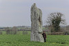
Neolithic and Bronze AgeSite Name: Menhir de la HuneCountry: France Département: Pays de la Loire:Mayenne (53) Type: Standing Stone (Menhir)
Nearest Town: Laval Nearest Village: Bazougers
Latitude: 48.019127N Longitude: 0.630196W
Condition:
| 5 | Perfect |
| 4 | Almost Perfect |
| 3 | Reasonable but with some damage |
| 2 | Ruined but still recognisable as an ancient site |
| 1 | Pretty much destroyed, possibly visible as crop marks |
| 0 | No data. |
| -1 | Completely destroyed |
| 5 | Superb |
| 4 | Good |
| 3 | Ordinary |
| 2 | Not Good |
| 1 | Awful |
| 0 | No data. |
| 5 | Can be driven to, probably with disabled access |
| 4 | Short walk on a footpath |
| 3 | Requiring a bit more of a walk |
| 2 | A long walk |
| 1 | In the middle of nowhere, a nightmare to find |
| 0 | No data. |
| 5 | co-ordinates taken by GPS or official recorded co-ordinates |
| 4 | co-ordinates scaled from a detailed map |
| 3 | co-ordinates scaled from a bad map |
| 2 | co-ordinates of the nearest village |
| 1 | co-ordinates of the nearest town |
| 0 | no data |
Internal Links:
External Links:
I have visited· I would like to visit
foz750 visited on 4th Mar 2024 - their rating: Cond: 4 Amb: 4 Access: 4 I visited today and was impressed with this singular menhir in a small field approximately 2km from the village of Bazouges.
It stands well over 5 meters in height and has various different lines and markings on its surface. I believe from local research that it was originally a polishing stone that was raised horizontally in the 1900s.
Even on a cold spring morning it is an imposing stone in a good setting.
")
Location Source: T4T35
Information and Pictures:
t4t35.fr
Wikipedia article
Sites mégalithiques de la Mayenne
Page originally by TheCaptain, text by foz750.
You may be viewing yesterday's version of this page. To see the most up to date information please register for a free account.
")
")
")
")
Do not use the above information on other web sites or publications without permission of the contributor.
Nearby Images from Flickr
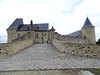
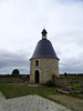
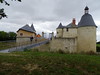

The above images may not be of the site on this page, but were taken nearby. They are loaded from Flickr so please click on them for image credits.
Click here to see more info for this site
Nearby sites
Click here to view sites on an interactive map of the areaKey: Red: member's photo, Blue: 3rd party photo, Yellow: other image, Green: no photo - please go there and take one, Grey: site destroyed
Download sites to:
KML (Google Earth)
GPX (GPS waypoints)
CSV (Garmin/Navman)
CSV (Excel)
To unlock full downloads you need to sign up as a Contributory Member. Otherwise downloads are limited to 50 sites.
Turn off the page maps and other distractions
Nearby sites listing. In the following links * = Image available
7.0km WSW 246° Entrammes Oppidum Ancient Village or Settlement
8.8km W 272° Menhir du Haut-Fougeray Standing Stone (Menhir)
16.6km NNW 326° Oppidum du Château Meignan Ancient Village or Settlement
17.1km E 100° Grotte de la Dérouine Cave or Rock Shelter
17.3km E 100° Cave à Margot* Cave or Rock Shelter
22.7km NE 48° Menhir Basilique Notre Dame de L'épine* Standing Stone (Menhir)
22.9km NE 48° Menhir Marie d'Évron* Standing Stone (Menhir)
23.2km NNW 333° Menhir du Faix du Diable* Standing Stone (Menhir)
24.7km ENE 64° Dolmen des Erves* Burial Chamber or Dolmen
24.7km N 4° Les Chauvières* Standing Stone (Menhir)
25.1km ENE 64° Dolmen des Iles* Burial Chamber or Dolmen
25.3km ENE 73° La Table des Diables* Burial Chamber or Dolmen
26.7km NE 38° Pierre Aigue, Richebourg* Passage Grave
27.0km NE 39° Dolmen des Pierres Jumelles* Burial Chamber or Dolmen
27.1km NW 321° Clivay Menhir* Standing Stone (Menhir)
27.9km NNE 21° Camp Romain de Jublains* Ancient Village or Settlement
28.0km NNE 21° Jublains museum stone* Standing Stone (Menhir)
28.0km N 1° Oppidum de Moulay Ancient Village or Settlement
28.0km W 281° Menhir du Grand Bois (Ruillé-le-Gravelais) Standing Stone (Menhir)
28.2km NNE 21° Les Fouées* Standing Stone (Menhir)
28.2km NNE 21° Jublains Stèle Gauloise* Standing Stone (Menhir)
28.3km ENE 65° Stele des Trois Poiriers* Sculptured Stone
28.6km NE 47° La Chaise du Diable* Natural Stone / Erratic / Other Natural Feature
28.7km NE 50° Dolmen de la Pierre au Renard Burial Chamber or Dolmen
28.9km NE 46° Pierres dit Palais du Diable* Natural Stone / Erratic / Other Natural Feature
View more nearby sites and additional images


 We would like to know more about this location. Please feel free to add a brief description and any relevant information in your own language.
 Wir möchten mehr über diese Stätte erfahren. Bitte zögern Sie nicht, eine kurze Beschreibung und relevante Informationen in Deutsch hinzuzufügen.
 Nous aimerions en savoir encore un peu sur les lieux. S'il vous plaît n'hesitez pas à ajouter une courte description et tous les renseignements pertinents dans votre propre langue.
 Quisieramos informarnos un poco más de las lugares. No dude en añadir una breve descripción y otros datos relevantes en su propio idioma.