


<< Our Photo Pages >> Greetham - Holy Well or Sacred Spring in England in Leicestershire and Rutland
Submitted by enkidu41 on Tuesday, 31 August 2004 Page Views: 9078
Springs and Holy WellsSite Name: GreethamCountry: England
NOTE: This site is 2.409 km away from the location you searched for.
County: Leicestershire and Rutland Type: Holy Well or Sacred Spring
Nearest Town: Oakham Nearest Village: Greetham
Map Ref: SK924146
Latitude: 52.721170N Longitude: 0.633405W
Condition:
| 5 | Perfect |
| 4 | Almost Perfect |
| 3 | Reasonable but with some damage |
| 2 | Ruined but still recognisable as an ancient site |
| 1 | Pretty much destroyed, possibly visible as crop marks |
| 0 | No data. |
| -1 | Completely destroyed |
| 5 | Superb |
| 4 | Good |
| 3 | Ordinary |
| 2 | Not Good |
| 1 | Awful |
| 0 | No data. |
| 5 | Can be driven to, probably with disabled access |
| 4 | Short walk on a footpath |
| 3 | Requiring a bit more of a walk |
| 2 | A long walk |
| 1 | In the middle of nowhere, a nightmare to find |
| 0 | No data. |
| 5 | co-ordinates taken by GPS or official recorded co-ordinates |
| 4 | co-ordinates scaled from a detailed map |
| 3 | co-ordinates scaled from a bad map |
| 2 | co-ordinates of the nearest village |
| 1 | co-ordinates of the nearest town |
| 0 | no data |
Be the first person to rate this site - see the 'Contribute!' box in the right hand menu.
Internal Links:
External Links:
")
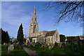
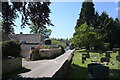
The well is at the village church of St. Mary's. The well head has stone surrounds, a substantial and well-cared for structure.
The well is now dry and the cistern at the back suggests the flow has always been meagre or erratic or possibly that the structure is fed by piped water.
On one stone is the following inscription (similar to the Wishing Well at Ashwell):
All ye who hither come to drink
rest not your thoughts below
remember Jacob's Well and think
whence living waters flow.
Based on the description by, and used by kind permission of, Bob Trubshaw, from his Interactive Little-known Leicestershire and Rutland CD-ROM.
You may be viewing yesterday's version of this page. To see the most up to date information please register for a free account.
")
Do not use the above information on other web sites or publications without permission of the contributor.
Nearby Images from Geograph Britain and Ireland:
©2015(licence)
©2021(licence)
©2021(licence)
©2021(licence)
©2021(licence)
The above images may not be of the site on this page, they are loaded from Geograph.
Please Submit an Image of this site or go out and take one for us!
Click here to see more info for this site
Nearby sites
Key: Red: member's photo, Blue: 3rd party photo, Yellow: other image, Green: no photo - please go there and take one, Grey: site destroyed
Download sites to:
KML (Google Earth)
GPX (GPS waypoints)
CSV (Garmin/Navman)
CSV (Excel)
To unlock full downloads you need to sign up as a Contributory Member. Otherwise downloads are limited to 50 sites.
Turn off the page maps and other distractions
Nearby sites listing. In the following links * = Image available
5.1km W 261° Ashwell Wishing Well* Holy Well or Sacred Spring (SK874137)
6.7km SSE 157° Sheela-Na-Gig (Empingham)* Sculptured Stone (SK951085)
7.6km SW 229° Oakham Timber Circle Timber Circle (SK867095)
7.7km SW 230° Our Lady's Well (Oakham)* Holy Well or Sacred Spring (SK866095)
7.7km E 81° Holy Well (Careby and Aunby) Holy Well or Sacred Spring (TF00031598)
8.1km WSW 246° Langham Lodge Long Barrow (SK850112)
9.3km ESE 110° Walk Farm Enclosure Ancient Village or Settlement (TF012116)
10.1km SSE 160° Wytchley Warren (Edith Weston) Cairn (SK961052)
11.5km NNW 347° Fish Well* Holy Well or Sacred Spring (SK89602578)
11.6km E 86° Careby Camp* Hillfort (TF040157)
12.1km SSW 195° The Old Maze* Turf Maze (SK8954902833)
12.1km SW 230° The Braunston Goddess* Sculptured Stone (SK8324606581)
12.3km NNW 328° St Bartholomew (Sproxton)* Ancient Cross (SK8566624904)
13.5km SSE 156° Tixover Grange Long Barrow (SK981023)
14.2km SW 214° Ridlington settlement Misc. Earthwork (SK846027)
14.5km NNW 338° King Lud’s Intrenchments Misc. Earthwork (SK867279)
14.6km ESE 118° Uffington Causewayed Enclosure Causewayed Enclosure (TF055080)
15.5km W 280° Burton Lazars Stockwell* Holy Well or Sacred Spring (SK770170)
16.5km W 262° Burrough-on-the-hill* Hillfort (SK761119)
16.6km ESE 105° Barholm Causewayed Enclosure Causewayed Enclosure (TF085105)
17.6km NNE 24° Round Hills Fort* Hillfort (SK992308)
17.6km ESE 118° Barnack (Timber Circle) Timber Circle (TF081066)
17.8km ESE 117° Barnack Cursus Cursus (TF08360672)
18.2km ESE 123° St John the Baptist (Barnack)* Ancient Cross (TF07930505)
18.6km N 11° Burgh Banks Hillfort (SK955330)
View more nearby sites and additional images


 We would like to know more about this location. Please feel free to add a brief description and any relevant information in your own language.
 Wir möchten mehr über diese Stätte erfahren. Bitte zögern Sie nicht, eine kurze Beschreibung und relevante Informationen in Deutsch hinzuzufügen.
 Nous aimerions en savoir encore un peu sur les lieux. S'il vous plaît n'hesitez pas à ajouter une courte description et tous les renseignements pertinents dans votre propre langue.
 Quisieramos informarnos un poco más de las lugares. No dude en añadir una breve descripción y otros datos relevantes en su propio idioma.