

<< Our Photo Pages >> Wishing Chair Cross - Ancient Cross in England in Yorkshire (North)
Submitted by johndhunter on Saturday, 18 January 2020 Page Views: 1208
Early Medieval (Dark Age)Site Name: Wishing Chair CrossCountry: England
NOTE: This site is 0.525 km away from the location you searched for.
County: Yorkshire (North) Type: Ancient Cross
Nearest Town: Whitby
Map Ref: NZ8849010975
Latitude: 54.486410N Longitude: 0.635565W
Condition:
| 5 | Perfect |
| 4 | Almost Perfect |
| 3 | Reasonable but with some damage |
| 2 | Ruined but still recognisable as an ancient site |
| 1 | Pretty much destroyed, possibly visible as crop marks |
| 0 | No data. |
| -1 | Completely destroyed |
| 5 | Superb |
| 4 | Good |
| 3 | Ordinary |
| 2 | Not Good |
| 1 | Awful |
| 0 | No data. |
| 5 | Can be driven to, probably with disabled access |
| 4 | Short walk on a footpath |
| 3 | Requiring a bit more of a walk |
| 2 | A long walk |
| 1 | In the middle of nowhere, a nightmare to find |
| 0 | No data. |
| 5 | co-ordinates taken by GPS or official recorded co-ordinates |
| 4 | co-ordinates scaled from a detailed map |
| 3 | co-ordinates scaled from a bad map |
| 2 | co-ordinates of the nearest village |
| 1 | co-ordinates of the nearest town |
| 0 | no data |
Internal Links:
External Links:
I have visited· I would like to visit
cactus_chris visited on 26th Oct 2021 - their rating: Cond: 4 Amb: 4 Access: 5
")
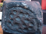
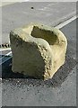
Located on the southern side of the junction of Stakesby Road and Love Lane in what is now the western outskirts of Whitby. Originally a mediaeval mile cross whose original name is unknown, it marked the approach to Whitby Abbey. All that remains today is the mediaeval base with a socket cut into it whose south east* lip has broken away so that it looks like a small chair. There is an old black and white photo of this cross in T.H.Woodwards 1934 book “The Crosses of the North York Moors” page 15 and what appears to be the broken lip lying in front of it, though where it has broken from looks well worn. Also whilst today it is has a pavement built around it, at that time it was on a grass verge beside what appears to be a fairly narrow lane rather than a road as such. The name Wishing Chair Cross first appears on the 1927 OS map, earlier OS maps just refer to it as a Stone Cross (Base of or Pedestal)
Local tradition says that for those children who are small enough to fit in this chair and haven’t been naughty any wish they make will come true – hence its name.
*Both Pastscape and Historic England have more information on this cross at Monument 29467 and List Entry 1009851 respectively, however both say that it is the northern edge (lip) of the base that is missing, this is incorrect it is the south east edge (lip).
Note: On the north east side of the junction there is a modern cross erected in 1957 to commemorate the Festival of Britain, this information is written on the right hand side of the shaft. On the left hand side of the shaft it says “Restoration of a mile cross of Whitby Abbey”. This cross also defines the bounds of the Abbey. However looking at old OS maps I can see no evidence that there was ever an earlier cross at this location, the maps only indicate the location of the Wishing Chair Cross.
You may be viewing yesterday's version of this page. To see the most up to date information please register for a free account.
")
")
")
")
Do not use the above information on other web sites or publications without permission of the contributor.
Nearby Images from Geograph Britain and Ireland:
©2019(licence)
©2013(licence)
©2017(licence)
©2012(licence)

©2006(licence)
The above images may not be of the site on this page, they are loaded from Geograph.
Please Submit an Image of this site or go out and take one for us!
Click here to see more info for this site
Nearby sites
Key: Red: member's photo, Blue: 3rd party photo, Yellow: other image, Green: no photo - please go there and take one, Grey: site destroyed
Download sites to:
KML (Google Earth)
GPX (GPS waypoints)
CSV (Garmin/Navman)
CSV (Excel)
To unlock full downloads you need to sign up as a Contributory Member. Otherwise downloads are limited to 50 sites.
Turn off the page maps and other distractions
Nearby sites listing. In the following links * = Image available
946m E 98° Whitby Museum* Museum (NZ8943210865)
1.6km E 81° Caedmon's Cross (Whitby)* Ancient Cross (NZ90091126)
1.8km E 81° Whitby Cross* Ancient Cross (NZ90231129)
1.8km E 83° Whitby Abbey* Early Christian Sculptured Stone (NZ9031611231)
3.5km ESE 116° Robin Hood Close and Little John Close* Modern Stone Circle etc (NZ91710949)
3.9km SW 221° Aislaby Moor Rock Art (NZ8608)
4.1km WNW 303° St Oswald's Church (Lythe)* Ancient Cross (NZ8501613164)
4.5km WSW 244° Dunsley Moor East* Round Barrow(s) (NZ8449208942)
4.8km WSW 246° Swarth Howe Barrow, stone row and ring cairn* Stone Row / Alignment (NZ8417908930)
4.8km WSW 246° Dunsley Moor Stone Row* Stone Row / Alignment (NZ841089)
4.9km WSW 243° Swarth Howe Cross* Ancient Cross (NZ8412508649)
5.1km SE 134° Low Hawsker Cross* Ancient Cross (NZ922075)
5.1km WSW 243° Aislaby Iron Age Barrow Misc. Earthwork (NZ8394708604)
5.8km WNW 292° Wades Stone (South)* Standing Stone (Menhir) (NZ8305113007)
6.5km WNW 303° Wades Stone (North)* Standing Stone (Menhir) (NZ8295414414)
6.6km SE 129° Boiling Well (Yorkshire)* Holy Well or Sacred Spring (NZ93680689)
7.0km SSW 206° Flat Howe (Sleights Moor)* Round Barrow(s) (NZ85510461)
7.1km NW 307° Butter Howe* Round Barrow(s) (NZ82731513)
7.2km SSW 210° High Bridestones (Yorks)* Stone Circle (NZ8499704629)
7.3km SW 214° Low Bridestones (Yorks)* Stone Row / Alignment (NZ8454104859)
7.4km SSE 154° Postgate Cross (Graystone Hills)* Ancient Cross (NZ9182504342)
7.5km WSW 250° Lady Cross (Egton Low Moor)* Ancient Cross (NZ8147708327)
7.6km SSW 193° Greenland's Howe (Sleights Moor)* Cist (NZ8688103552)
7.6km WNW 301° Claymore Well (Kettleness) Holy Well or Sacred Spring (NZ819148)
7.8km SSW 203° Pen Howe (Sleights Moor)* Round Barrow(s) (NZ8563903722)
View more nearby sites and additional images


 We would like to know more about this location. Please feel free to add a brief description and any relevant information in your own language.
 Wir möchten mehr über diese Stätte erfahren. Bitte zögern Sie nicht, eine kurze Beschreibung und relevante Informationen in Deutsch hinzuzufügen.
 Nous aimerions en savoir encore un peu sur les lieux. S'il vous plaît n'hesitez pas à ajouter une courte description et tous les renseignements pertinents dans votre propre langue.
 Quisieramos informarnos un poco más de las lugares. No dude en añadir una breve descripción y otros datos relevantes en su propio idioma.