

<< Our Photo Pages >> Lady Well (Tuesley) - Holy Well or Sacred Spring in England in Surrey
Submitted by DavidCWoods on Saturday, 26 February 2005 Page Views: 10399
Springs and Holy WellsSite Name: Lady Well (Tuesley)Country: England
NOTE: This site is 2.746 km away from the location you searched for.
County: Surrey Type: Holy Well or Sacred Spring
Nearest Town: Godalming Nearest Village: Tuesley
Map Ref: SU968421
Latitude: 51.169960N Longitude: 0.616813W
Condition:
| 5 | Perfect |
| 4 | Almost Perfect |
| 3 | Reasonable but with some damage |
| 2 | Ruined but still recognisable as an ancient site |
| 1 | Pretty much destroyed, possibly visible as crop marks |
| 0 | No data. |
| -1 | Completely destroyed |
| 5 | Superb |
| 4 | Good |
| 3 | Ordinary |
| 2 | Not Good |
| 1 | Awful |
| 0 | No data. |
| 5 | Can be driven to, probably with disabled access |
| 4 | Short walk on a footpath |
| 3 | Requiring a bit more of a walk |
| 2 | A long walk |
| 1 | In the middle of nowhere, a nightmare to find |
| 0 | No data. |
| 5 | co-ordinates taken by GPS or official recorded co-ordinates |
| 4 | co-ordinates scaled from a detailed map |
| 3 | co-ordinates scaled from a bad map |
| 2 | co-ordinates of the nearest village |
| 1 | co-ordinates of the nearest town |
| 0 | no data |
Internal Links:
External Links:
 (PID:12335)")
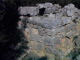
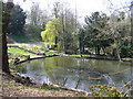
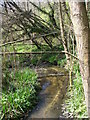
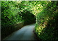
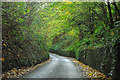
At the bottom of the road, known for centuries as Ladywell Hill, just before the stream running under the road we find Busbridge Lakes on the left. A tall fence prevents trespassers, or even casual visitors from reaching the water – apparently fees are payable for fishing. From the map, it would appear that the well, or rather spring, is next to the fence, where the footpath leaves the road, and flowing water is visible through the fence.
Apparently the parish church of St. John the Baptist, Busbridge, contains a stained glass window showing Augustine baptising King Ethelbert and another of a pilgrim drinking from the spring, whilst on the hill above him the Minster Church may be seen.
You may be viewing yesterday's version of this page. To see the most up to date information please register for a free account.
 (PID:12390)")
Do not use the above information on other web sites or publications without permission of the contributor.
Nearby Images from Geograph Britain and Ireland:
©2010(licence)
©2010(licence)
©2012(licence)
©2011(licence)
©2011(licence)
The above images may not be of the site on this page, they are loaded from Geograph.
Please Submit an Image of this site or go out and take one for us!
Click here to see more info for this site
Nearby sites
Key: Red: member's photo, Blue: 3rd party photo, Yellow: other image, Green: no photo - please go there and take one, Grey: site destroyed
Download sites to:
KML (Google Earth)
GPX (GPS waypoints)
CSV (Garmin/Navman)
CSV (Excel)
To unlock full downloads you need to sign up as a Contributory Member. Otherwise downloads are limited to 50 sites.
Turn off the page maps and other distractions
Nearby sites listing. In the following links * = Image available
5.0km SE 135° Hascombe Hill* Hillfort (TQ004386)
5.6km SE 132° The Dragonstones Modern Stone Circle etc (TQ0105038489)
6.5km SSE 155° St Mary the Virgin's Well* Holy Well or Sacred Spring (SU997363)
6.6km NNE 24° Artington Spring* Holy Well or Sacred Spring (SU994482)
7.2km NNE 19° St. Edward's Well* Holy Well or Sacred Spring (SU9949)
7.4km NW 311° Hillbury hillfort* Hillfort (SU911468)
7.7km NNE 23° Guildford Museum* Museum (SU9968349258)
8.0km WNW 292° Crooksbury Common Barrows* Barrow Cemetery (SU893450)
8.2km WNW 287° Tilford Barrows Barrow Cemetery (SU889443)
8.3km WNW 296° Culverswell Barrow* Round Barrow(s) (SU892456)
8.4km NE 40° Tyting Farm Bowl Barrow* Round Barrow(s) (TQ02124857)
8.5km NE 45° St Martha's on the Hill Earth Circles* Misc. Earthwork (TQ027482)
9.0km NE 49° Lid Well* Holy Well or Sacred Spring (TQ03554815)
9.7km WNW 296° Soldier's Ring* Hillfort (SU880462)
10.1km WNW 295° Botany Hill Camp Hillfort (SU875462)
10.3km NE 56° Albury Fishponds* Natural Stone / Erratic / Other Natural Feature (TQ053480)
10.4km WNW 291° St. Mary's Well (Compton)* Holy Well or Sacred Spring (SU870457)
10.7km NE 55° Weston Wood Platform Mound* Round Barrow(s) (TQ055484)
10.8km ENE 62° Albury Park Mound* Round Barrow(s) (TQ062474)
10.8km NE 56° Weston Woods Cromlech* Standing Stones (TQ05644839)
10.9km SW 216° Haslemere Educational Museum* Museum (SU9061833107)
11.3km NE 56° The Silent Pool* Holy Well or Sacred Spring (TQ0606148582)
11.5km W 264° Frensham Common Barrows* Barrow Cemetery (SU85334070)
11.8km NNE 15° Whitmoor Common* Round Barrow(s) (SU996536)
12.2km WNW 300° Badshot Lea* Long Barrow (SU86084793)
View more nearby sites and additional images


 We would like to know more about this location. Please feel free to add a brief description and any relevant information in your own language.
 Wir möchten mehr über diese Stätte erfahren. Bitte zögern Sie nicht, eine kurze Beschreibung und relevante Informationen in Deutsch hinzuzufügen.
 Nous aimerions en savoir encore un peu sur les lieux. S'il vous plaît n'hesitez pas à ajouter une courte description et tous les renseignements pertinents dans votre propre langue.
 Quisieramos informarnos un poco más de las lugares. No dude en añadir una breve descripción y otros datos relevantes en su propio idioma.