


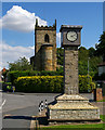
<< Our Photo Pages >> Broughton Cross - Ancient Cross in England in Lincolnshire
Submitted by Thorgrim on Wednesday, 17 August 2005 Page Views: 5696
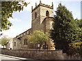
Early Medieval (Dark Age)Site Name: Broughton CrossCountry: England County: Lincolnshire Type: Ancient Cross
Nearest Town: Scunthorpe Nearest Village: Broughton
Map Ref: SE960086
Latitude: 53.565241N Longitude: 0.551989W
Condition:
| 5 | Perfect |
| 4 | Almost Perfect |
| 3 | Reasonable but with some damage |
| 2 | Ruined but still recognisable as an ancient site |
| 1 | Pretty much destroyed, possibly visible as crop marks |
| 0 | No data. |
| -1 | Completely destroyed |
| 5 | Superb |
| 4 | Good |
| 3 | Ordinary |
| 2 | Not Good |
| 1 | Awful |
| 0 | No data. |
| 5 | Can be driven to, probably with disabled access |
| 4 | Short walk on a footpath |
| 3 | Requiring a bit more of a walk |
| 2 | A long walk |
| 1 | In the middle of nowhere, a nightmare to find |
| 0 | No data. |
| 5 | co-ordinates taken by GPS or official recorded co-ordinates |
| 4 | co-ordinates scaled from a detailed map |
| 3 | co-ordinates scaled from a bad map |
| 2 | co-ordinates of the nearest village |
| 1 | co-ordinates of the nearest town |
| 0 | no data |
Internal Links:
External Links:
")
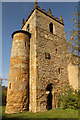
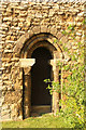
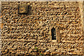
Anglian cross shaft in the church
You may be viewing yesterday's version of this page. To see the most up to date information please register for a free account.
")
Do not use the above information on other web sites or publications without permission of the contributor.
Nearby Images from Geograph Britain and Ireland:
©2005(licence)
©2015(licence)
©2015(licence)
©2015(licence)
©2009(licence)
The above images may not be of the site on this page, they are loaded from Geograph.
Please Submit an Image of this site or go out and take one for us!
Click here to see more info for this site
Nearby sites
Key: Red: member's photo, Blue: 3rd party photo, Yellow: other image, Green: no photo - please go there and take one, Grey: site destroyed
Download sites to:
KML (Google Earth)
GPX (GPS waypoints)
CSV (Garmin/Navman)
CSV (Excel)
To unlock full downloads you need to sign up as a Contributory Member. Otherwise downloads are limited to 50 sites.
Turn off the page maps and other distractions
Nearby sites listing. In the following links * = Image available
2.5km NW 312° Gokwell Priory (Broughton) Misc. Earthwork (SE94081028)
5.4km E 100° St. Helen's Well (Wrawby) Holy Well or Sacred Spring (TA0137907720)
7.5km WNW 299° Crosby Stone Natural Stone / Erratic / Other Natural Feature (SE893121)
7.8km NW 317° Dragonby* Natural Stone / Erratic / Other Natural Feature (SE905142)
9.3km N 351° Holy Well (Winterton) Holy Well or Sacred Spring (SE944178)
10.4km SSW 194° Ashwell* Holy Well or Sacred Spring (SK936985)
11.1km SE 131° The Maiden-Well Holy Well or Sacred Spring (TA045015)
11.2km SE 130° Maiden Well (Maidenwell) Holy Well or Sacred Spring (TA047015)
12.5km ENE 75° Yarborough Camp Hillfort (TA081120)
13.3km ENE 62° Howe Hill (Lincolnshire) Round Barrow(s) (TA07631510)
13.3km ESE 102° Holy Wells (Barnetby le Wold) Holy Well or Sacred Spring (TA091061)
14.9km W 262° West Butterwick Henge (SE813062)
14.9km NW 326° Kell Well (Walcot)* Holy Well or Sacred Spring (SE873207)
15.3km NNW 329° Countess Close* Ancient Village or Settlement (SE879216)
15.4km NNW 330° Julian's Bower* Turf Maze (SE880218)
17.1km ESE 109° Fonaby Stone* Standing Stones (TA123033)
17.3km E 90° Brocklesby Park (Great Limber) Cairn (TA1332708902)
17.3km ESE 116° Syfer Spring Holy Well or Sacred Spring (TA117012)
17.3km ESE 116° Holy Well (Caistor) Holy Well or Sacred Spring (TA1172501229)
17.7km S 190° St. Helen's Well (Hemswell)* Holy Well or Sacred Spring (SK932911)
18.6km WSW 251° Holy Well (Lower Burnham)* Holy Well or Sacred Spring (SE78520205)
18.7km S 182° Aisthorpe springs Holy Well or Sacred Spring (SK956899)
19.0km S 175° Newell's Well (Glentham) Holy Well or Sacred Spring (SK981897)
19.3km WNW 284° Crowle Stone* Early Christian Sculptured Stone (SE772130)
21.2km SE 126° Hills Brough* Long Barrow (TF1337396415)
View more nearby sites and additional images


 We would like to know more about this location. Please feel free to add a brief description and any relevant information in your own language.
 Wir möchten mehr über diese Stätte erfahren. Bitte zögern Sie nicht, eine kurze Beschreibung und relevante Informationen in Deutsch hinzuzufügen.
 Nous aimerions en savoir encore un peu sur les lieux. S'il vous plaît n'hesitez pas à ajouter une courte description et tous les renseignements pertinents dans votre propre langue.
 Quisieramos informarnos un poco más de las lugares. No dude en añadir una breve descripción y otros datos relevantes en su propio idioma.