


<< Text Pages >> Holy Well (Careby and Aunby) - Holy Well or Sacred Spring in England in Lincolnshire
Submitted by HOLYWELL on Sunday, 16 January 2011 Page Views: 5806
Springs and Holy WellsSite Name: Holy Well (Careby and Aunby) Alternative Name: Hele wellCountry: England
NOTE: This site is 2.266 km away from the location you searched for.
County: Lincolnshire Type: Holy Well or Sacred Spring
Nearest Town: Stamford Nearest Village: Careby Aunby
Map Ref: TF00031598
Latitude: 52.732217N Longitude: 0.520058W
Condition:
| 5 | Perfect |
| 4 | Almost Perfect |
| 3 | Reasonable but with some damage |
| 2 | Ruined but still recognisable as an ancient site |
| 1 | Pretty much destroyed, possibly visible as crop marks |
| 0 | No data. |
| -1 | Completely destroyed |
| 5 | Superb |
| 4 | Good |
| 3 | Ordinary |
| 2 | Not Good |
| 1 | Awful |
| 0 | No data. |
| 5 | Can be driven to, probably with disabled access |
| 4 | Short walk on a footpath |
| 3 | Requiring a bit more of a walk |
| 2 | A long walk |
| 1 | In the middle of nowhere, a nightmare to find |
| 0 | No data. |
| 5 | co-ordinates taken by GPS or official recorded co-ordinates |
| 4 | co-ordinates scaled from a detailed map |
| 3 | co-ordinates scaled from a bad map |
| 2 | co-ordinates of the nearest village |
| 1 | co-ordinates of the nearest town |
| 0 | no data |
Internal Links:
External Links:
Holy Well or Sacred Spring in Lincolnshire
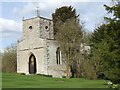
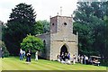
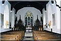
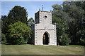
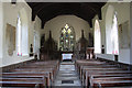
Here is an interesting site which gave its name to the hamlet. A local tradition claims that there was once a religious house by the well that was the home to a holy woman called Ade. She bathed the eyes of the blind and thus restored their sight. It would seem that the well was named after her. The settlement was called Bredestorp, which was mentioned in Doomsday but afterwards disappeared. (Earl Morcar, brother-in-law of King Harold is said to have held land in Bredestorp). Now it lies in the private grounds of Holywell Hall which is open once a year. In fact there are two wells, one being a rectangular dry chamber bsside the small parish church of St. Wilfred now a private chapel and built in 1700s but possibly on an earlier site and certainly with stones from Aunby church. The other a circular well full of water in a copse between the chapel and the well. Its waters are sadly not accessible. This may be the St. Winifreds also mentioned.
You may be viewing yesterday's version of this page. To see the most up to date information please register for a free account.
Do not use the above information on other web sites or publications without permission of the contributor.
Nearby Images from Geograph Britain and Ireland:
©2009(licence)
©2015(licence)
©2015(licence)
©2011(licence)
©2011(licence)
The above images may not be of the site on this page, they are loaded from Geograph.
Please Submit an Image of this site or go out and take one for us!
Click here to see more info for this site
Nearby sites
Key: Red: member's photo, Blue: 3rd party photo, Yellow: other image, Green: no photo - please go there and take one, Grey: site destroyed
Download sites to:
KML (Google Earth)
GPX (GPS waypoints)
CSV (Garmin/Navman)
CSV (Excel)
To unlock full downloads you need to sign up as a Contributory Member. Otherwise downloads are limited to 50 sites.
Turn off the page maps and other distractions
Nearby sites listing. In the following links * = Image available
4.0km E 95° Careby Camp* Hillfort (TF040157)
4.5km SSE 166° Walk Farm Enclosure Ancient Village or Settlement (TF012116)
7.7km W 261° Greetham* Holy Well or Sacred Spring (SK924146)
8.9km SW 214° Sheela-Na-Gig (Empingham)* Sculptured Stone (SK951085)
9.7km SSE 147° Uffington Causewayed Enclosure Causewayed Enclosure (TF055080)
10.1km SE 124° Barholm Causewayed Enclosure Causewayed Enclosure (TF085105)
11.5km SSW 201° Wytchley Warren (Edith Weston) Cairn (SK961052)
12.4km SE 141° Barnack (Timber Circle) Timber Circle (TF081066)
12.4km SE 139° Barnack Cursus Cursus (TF08360672)
12.8km W 261° Ashwell Wishing Well* Holy Well or Sacred Spring (SK874137)
13.5km SE 145° St John the Baptist (Barnack)* Ancient Cross (TF07930505)
13.6km SE 135° Bainton Cursus Cursus (TF099066)
13.8km S 189° Tixover Grange Long Barrow (SK981023)
14.0km SE 124° Maxey Cursus Cursus (TF118083)
14.0km SE 124° Maxey Cursus Cursus (TF11800830)
14.3km NW 314° Fish Well* Holy Well or Sacred Spring (SK89602578)
14.8km WSW 245° Oakham Timber Circle Timber Circle (SK867095)
14.8km N 358° Round Hills Fort* Hillfort (SK992308)
14.9km WSW 245° Our Lady's Well (Oakham)* Holy Well or Sacred Spring (SK866095)
14.9km SE 125° Maxey Pit Circle A Timber Circle (TF125078)
14.9km SE 125° Maxey Pit Circle A Timber Circle (TF125077)
15.0km SE 125° Maxey Henge Henge (TF12600772)
15.7km WSW 253° Langham Lodge Long Barrow (SK850112)
15.8km SE 124° Maxey Cursus Cursus (TF133074)
15.9km ESE 123° Etton Causewayed Enclosure* Causewayed Enclosure (TF135075)
View more nearby sites and additional images


 We would like to know more about this location. Please feel free to add a brief description and any relevant information in your own language.
 Wir möchten mehr über diese Stätte erfahren. Bitte zögern Sie nicht, eine kurze Beschreibung und relevante Informationen in Deutsch hinzuzufügen.
 Nous aimerions en savoir encore un peu sur les lieux. S'il vous plaît n'hesitez pas à ajouter une courte description et tous les renseignements pertinents dans votre propre langue.
 Quisieramos informarnos un poco más de las lugares. No dude en añadir una breve descripción y otros datos relevantes en su propio idioma.