

<< Our Photo Pages >> Menhir dit Pierre Debout (Reviers) - Standing Stone (Menhir) in France in Normandie:Calvados (14)
Submitted by TheCaptain on Sunday, 19 December 2004 Page Views: 18750
Neolithic and Bronze AgeSite Name: Menhir dit Pierre Debout (Reviers) Alternative Name: Reviers menhirCountry: France
NOTE: This site is 3.513 km away from the location you searched for.
Département: Normandie:Calvados (14) Type: Standing Stone (Menhir)
Nearest Town: Caen Nearest Village: Reviers
Latitude: 49.301937N Longitude: 0.455405W
Condition:
| 5 | Perfect |
| 4 | Almost Perfect |
| 3 | Reasonable but with some damage |
| 2 | Ruined but still recognisable as an ancient site |
| 1 | Pretty much destroyed, possibly visible as crop marks |
| 0 | No data. |
| -1 | Completely destroyed |
| 5 | Superb |
| 4 | Good |
| 3 | Ordinary |
| 2 | Not Good |
| 1 | Awful |
| 0 | No data. |
| 5 | Can be driven to, probably with disabled access |
| 4 | Short walk on a footpath |
| 3 | Requiring a bit more of a walk |
| 2 | A long walk |
| 1 | In the middle of nowhere, a nightmare to find |
| 0 | No data. |
| 5 | co-ordinates taken by GPS or official recorded co-ordinates |
| 4 | co-ordinates scaled from a detailed map |
| 3 | co-ordinates scaled from a bad map |
| 2 | co-ordinates of the nearest village |
| 1 | co-ordinates of the nearest town |
| 0 | no data |
Internal Links:
External Links:
I have visited· I would like to visit
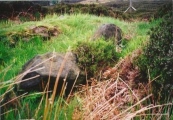
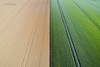
TheCaptain visited on 28th Sep 2006 - their rating: Cond: 2 Amb: 3 Access: 4 As I am right here and passing by, thought I may as well stop and take a look in the daylight. The crops in the field are growing, or more likely its been left fallow, but the ploughs have been right up to the stone and its fairly difficult to spot, even with this small growth. The poor stone is in a very sorry state, and could do with some TLC. Shame its so woefully looked after, so close to the well maintained large barrow.
TheCaptain couldn't find on 29th Dec 2005 Despite being marked on the ign map and having a good look all around I could find no sign of any menhir here. Perhaps it is fallen and somewhere within a field of oilseed Rape.
Later note. Having seen the 1:25000 ign map of the area the menhir is marked fairly close to the corner of the road and farm track right where I was looking originally. As I suspected the menhir must be fallen and hidden within the crop.
 (PID:18331)")
At the top of the hill, less than 1 km from the village centre, is a farm track leading to the south. The fallen and broken menhir is in the field between this track and the village, not more than 20 metres from the road. The stone is about 1.5 metres in length, and lies on the ground with several other broken pieces of stone around it, and has been ploughed right up to all around.
You may be viewing yesterday's version of this page. To see the most up to date information please register for a free account.
 (PID:264517)")
 (PID:264516)")
 (PID:24908)")
 (PID:18332)")
Do not use the above information on other web sites or publications without permission of the contributor.
Nearby Images from Flickr
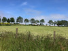
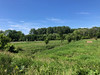

The above images may not be of the site on this page, but were taken nearby. They are loaded from Flickr so please click on them for image credits.
Click here to see more info for this site
Nearby sites
Click here to view sites on an interactive map of the areaKey: Red: member's photo, Blue: 3rd party photo, Yellow: other image, Green: no photo - please go there and take one, Grey: site destroyed
Download sites to:
KML (Google Earth)
GPX (GPS waypoints)
CSV (Garmin/Navman)
CSV (Excel)
To unlock full downloads you need to sign up as a Contributory Member. Otherwise downloads are limited to 50 sites.
Turn off the page maps and other distractions
Nearby sites listing. In the following links * = Image available
2.4km SSE 158° Menhir de la Demoiselle de Bracqueville* Standing Stone (Menhir)
2.7km WSW 243° Amblie necropole Barrow Cemetery
2.9km WSW 258° Colombiers-sur-Seulles tumulus* Chambered Tomb
3.8km W 261° Menhir des Demoiselles (Colombiers-sur-Seulles)* Standing Stone (Menhir)
4.7km WSW 247° Menhir des Planches* Standing Stone (Menhir)
5.1km SSE 157° Les Grosses Devises (W)* Standing Stones
5.7km SSE 153° Les Grosses Devises (E)* Standing Stone (Menhir)
7.4km E 79° Luc-sur-Mer menhir* Standing Stone (Menhir)
7.5km S 172° Pierre Tourneresse, Cairon* Chambered Tomb
8.2km SE 130° Mathieu necropole Barrow Cemetery
11.2km S 169° Rots necropolis Barrow Cemetery
12.2km ESE 122° Les Pierres Branlantes* Chambered Tomb
13.5km SE 127° Blainville-sur-Orne necropole Barrow Cemetery
14.6km SSE 153° Musée de Normandie* Museum
16.7km SSE 167° Menhir dit la Pierre Couchée (Louvigny)* Standing Stone (Menhir)
18.0km SSE 158° Fleury-sur-Orne necropolis* Barrow Cemetery
18.3km W 261° Musée Baron Gerard Museum
22.4km S 189° Nécropole mérovingienne à Évrecy* Ancient Village or Settlement
23.9km SSE 164° La Hogue* Chambered Tomb
24.0km SSE 162° La Hoguette* Chambered Tomb
26.5km SSW 214° Pierrelaye menhir* Standing Stone (Menhir)
26.9km WSW 247° Domaine de Castillon* Ancient Village or Settlement
28.1km SSE 166° Pierre Tournante (Fresnay-le-Puceux)* Standing Stone (Menhir)
32.1km SSE 163° Pierre Tourneresse (Gouvix)* Standing Stone (Menhir)
33.9km SSE 155° Bretteville-le-Rabet* Ancient Mine, Quarry or other Industry
View more nearby sites and additional images


 We would like to know more about this location. Please feel free to add a brief description and any relevant information in your own language.
 Wir möchten mehr über diese Stätte erfahren. Bitte zögern Sie nicht, eine kurze Beschreibung und relevante Informationen in Deutsch hinzuzufügen.
 Nous aimerions en savoir encore un peu sur les lieux. S'il vous plaît n'hesitez pas à ajouter une courte description et tous les renseignements pertinents dans votre propre langue.
 Quisieramos informarnos un poco más de las lugares. No dude en añadir una breve descripción y otros datos relevantes en su propio idioma.