


<< Our Photo Pages >> Holy Well (Sempringham) - Holy Well or Sacred Spring in England in Lincolnshire
Submitted by HOLYWELL on Saturday, 16 February 2008 Page Views: 7211
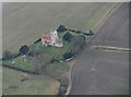
Springs and Holy WellsSite Name: Holy Well (Sempringham)Country: England
NOTE: This site is 3.602 km away from the location you searched for.
County: Lincolnshire Type: Holy Well or Sacred Spring
Nearest Village: Sempringham
Map Ref: TF10673282
Latitude: 52.881467N Longitude: 0.356858W
Condition:
| 5 | Perfect |
| 4 | Almost Perfect |
| 3 | Reasonable but with some damage |
| 2 | Ruined but still recognisable as an ancient site |
| 1 | Pretty much destroyed, possibly visible as crop marks |
| 0 | No data. |
| -1 | Completely destroyed |
| 5 | Superb |
| 4 | Good |
| 3 | Ordinary |
| 2 | Not Good |
| 1 | Awful |
| 0 | No data. |
| 5 | Can be driven to, probably with disabled access |
| 4 | Short walk on a footpath |
| 3 | Requiring a bit more of a walk |
| 2 | A long walk |
| 1 | In the middle of nowhere, a nightmare to find |
| 0 | No data. |
| 5 | co-ordinates taken by GPS or official recorded co-ordinates |
| 4 | co-ordinates scaled from a detailed map |
| 3 | co-ordinates scaled from a bad map |
| 2 | co-ordinates of the nearest village |
| 1 | co-ordinates of the nearest town |
| 0 | no data |
Internal Links:
External Links:
 (PID:36738)")
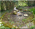
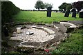
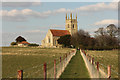
This well arises in a circular stone basin in the corner of the churchyard. This isolated church is associated with St. Gilbert founder of the Gilbertines, his father apparently constructing it. The well itself is thought to be curative and may have had associations with the saint. The water looks a little murky now which may indicate pollution from the farm.
You may be viewing yesterday's version of this page. To see the most up to date information please register for a free account.
Do not use the above information on other web sites or publications without permission of the contributor.
Nearby Images from Geograph Britain and Ireland:
©2014(licence)
©2007(licence)
©2015(licence)
©2014(licence)
©2019(licence)
The above images may not be of the site on this page, they are loaded from Geograph.
Please Submit an Image of this site or go out and take one for us!
Click here to see more info for this site
Nearby sites
Key: Red: member's photo, Blue: 3rd party photo, Yellow: other image, Green: no photo - please go there and take one, Grey: site destroyed
Download sites to:
KML (Google Earth)
GPX (GPS waypoints)
CSV (Garmin/Navman)
CSV (Excel)
To unlock full downloads you need to sign up as a Contributory Member. Otherwise downloads are limited to 50 sites.
Turn off the page maps and other distractions
Nearby sites listing. In the following links * = Image available
1.7km NE 38° Billingborough Wells* Holy Well or Sacred Spring (TF11703420)
2.7km NNE 26° Horbling Spring Well* Holy Well or Sacred Spring (TF11813528)
11.4km NNW 334° Butt Mound* Round Barrow(s) (TF055430)
11.4km NNW 334° Folk Moot* Round Barrow(s) (TF0536742981)
11.6km W 261° Round Hills Fort* Hillfort (SK992308)
15.1km W 272° Burgh Banks Hillfort (SK955330)
16.1km NW 312° Lady Well (Ancaster)* Holy Well or Sacred Spring (SK98404332)
17.8km N 4° Anwick Drake Stones* Natural Stone / Erratic / Other Natural Feature (TF114506)
18.0km WNW 303° Honington Camp* Hillfort (SK954424)
18.4km SSW 203° Careby Camp* Hillfort (TF040157)
19.9km SSW 214° Holy Well (Careby and Aunby) Holy Well or Sacred Spring (TF00031598)
20.7km SSE 162° Deeping St Nicholas Round Barrow(s) (TF174132)
20.7km SSE 162° Deeping St Nicholas 28 Timber Circle (TF174132)
22.2km WSW 253° Fish Well* Holy Well or Sacred Spring (SK89602578)
22.4km S 187° Barholm Causewayed Enclosure Causewayed Enclosure (TF085105)
23.2km SSW 205° Walk Farm Enclosure Ancient Village or Settlement (TF012116)
24.4km W 260° King Lud’s Intrenchments Misc. Earthwork (SK867279)
24.5km S 179° Maxey Cursus Cursus (TF11800830)
24.5km S 179° Maxey Cursus Cursus (TF118083)
24.8km S 170° Northborough Causewayed Enclosure Causewayed Enclosure (TF155085)
25.1km S 177° Maxey Pit Circle A Timber Circle (TF125078)
25.2km S 177° Maxey Henge Henge (TF12600772)
25.2km S 177° Maxey Pit Circle A Timber Circle (TF125077)
25.3km SSW 193° Uffington Causewayed Enclosure Causewayed Enclosure (TF055080)
25.5km S 175° Etton Causewayed Enclosure* Causewayed Enclosure (TF135075)
View more nearby sites and additional images


 We would like to know more about this location. Please feel free to add a brief description and any relevant information in your own language.
 Wir möchten mehr über diese Stätte erfahren. Bitte zögern Sie nicht, eine kurze Beschreibung und relevante Informationen in Deutsch hinzuzufügen.
 Nous aimerions en savoir encore un peu sur les lieux. S'il vous plaît n'hesitez pas à ajouter une courte description et tous les renseignements pertinents dans votre propre langue.
 Quisieramos informarnos un poco más de las lugares. No dude en añadir una breve descripción y otros datos relevantes en su propio idioma.