 with our Megalithic Portal iPhone app")


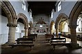
<< Our Photo Pages >> Walesby All Saints church carvings - Sculptured Stone in England in Lincolnshire
Submitted by Catrinm on Monday, 13 April 2020 Page Views: 1016
Medieval (High and Late)Site Name: Walesby All Saints church carvings Alternative Name: Ramblers church carvingsCountry: England
NOTE: This site is 5.886 km away from the location you searched for.
County: Lincolnshire Type: Sculptured Stone
Nearest Town: Market Rasen Nearest Village: Walesby
Map Ref: TF1382892388
Latitude: 53.416026N Longitude: 0.288804W
Condition:
| 5 | Perfect |
| 4 | Almost Perfect |
| 3 | Reasonable but with some damage |
| 2 | Ruined but still recognisable as an ancient site |
| 1 | Pretty much destroyed, possibly visible as crop marks |
| 0 | No data. |
| -1 | Completely destroyed |
| 5 | Superb |
| 4 | Good |
| 3 | Ordinary |
| 2 | Not Good |
| 1 | Awful |
| 0 | No data. |
| 5 | Can be driven to, probably with disabled access |
| 4 | Short walk on a footpath |
| 3 | Requiring a bit more of a walk |
| 2 | A long walk |
| 1 | In the middle of nowhere, a nightmare to find |
| 0 | No data. |
| 5 | co-ordinates taken by GPS or official recorded co-ordinates |
| 4 | co-ordinates scaled from a detailed map |
| 3 | co-ordinates scaled from a bad map |
| 2 | co-ordinates of the nearest village |
| 1 | co-ordinates of the nearest town |
| 0 | no data |
Internal Links:
External Links:
")
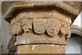
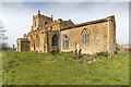
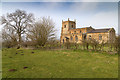
The 'Ramblers' church dates from 11th century but probably earlier. There are some enigmatic human face carvings which I really like. Worth a visit if you are in Lincolnshire
You may be viewing yesterday's version of this page. To see the most up to date information please register for a free account.
Do not use the above information on other web sites or publications without permission of the contributor.
Nearby Images from Geograph Britain and Ireland:
©2008(licence)
©2015(licence)
©2016(licence)
©2016(licence)
©2016(licence)
The above images may not be of the site on this page, they are loaded from Geograph.
Please Submit an Image of this site or go out and take one for us!
Click here to see more info for this site
Nearby sites
Key: Red: member's photo, Blue: 3rd party photo, Yellow: other image, Green: no photo - please go there and take one, Grey: site destroyed
Download sites to:
KML (Google Earth)
GPX (GPS waypoints)
CSV (Garmin/Navman)
CSV (Excel)
To unlock full downloads you need to sign up as a Contributory Member. Otherwise downloads are limited to 50 sites.
Turn off the page maps and other distractions
Nearby sites listing. In the following links * = Image available
3.4km E 93° Bully Hill (Tealby)* Round Barrow(s) (TF17279227)
4.0km ENE 71° Lud well (Stainton-Le-Vale)* Holy Well or Sacred Spring (TF17629376)
4.0km N 355° Hills Brough* Long Barrow (TF1337396415)
8.0km ENE 63° Ash Hill Long Barrow* Long Barrow (TF20889612)
8.2km ENE 71° Hoe Hill Long Barrow* Long Barrow (TF215953)
9.1km NNW 348° Syfer Spring Holy Well or Sacred Spring (TA117012)
9.1km NNW 348° Holy Well (Caistor) Holy Well or Sacred Spring (TA1172501229)
10.0km SSW 208° Wickenby Ancient Village or Settlement (TF0928883432)
10.1km NNE 32° Ash Holt Long Barrow* Long Barrow (TA1898001112)
10.5km SE 136° Burgh on Bain* Long Barrow (TF21298497)
10.9km ESE 122° Grims Mound* Round Barrow(s) (TF23258693)
11.0km N 353° Fonaby Stone* Standing Stones (TA123033)
11.3km SE 139° Burgh Top* Round Barrow(s) (TF21458406)
12.9km NW 316° Maiden Well (Maidenwell) Holy Well or Sacred Spring (TA047015)
13.0km NW 316° The Maiden-Well Holy Well or Sacred Spring (TA045015)
14.5km NNW 342° Holy Wells (Barnetby le Wold) Holy Well or Sacred Spring (TA091061)
15.9km W 262° Newell's Well (Glentham) Holy Well or Sacred Spring (SK981897)
16.5km N 360° Brocklesby Park (Great Limber) Cairn (TA1332708902)
18.2km NNE 21° Ragged Spring (Healing) Holy Well or Sacred Spring (TA199096)
18.3km W 264° Aisthorpe springs Holy Well or Sacred Spring (SK956899)
18.6km SE 124° Tathwell Long Barrow* Long Barrow (TF29458225)
19.3km NNE 25° Toot Hill Bowl Barrow Round Barrow(s) (TA21601011)
19.7km NW 322° St. Helen's Well (Wrawby) Holy Well or Sacred Spring (TA0137907720)
19.8km NE 35° Toot Hill Round Barrow* Round Barrow(s) (TA24800888)
20.4km NNW 345° Yarborough Camp Hillfort (TA081120)
View more nearby sites and additional images


 We would like to know more about this location. Please feel free to add a brief description and any relevant information in your own language.
 Wir möchten mehr über diese Stätte erfahren. Bitte zögern Sie nicht, eine kurze Beschreibung und relevante Informationen in Deutsch hinzuzufügen.
 Nous aimerions en savoir encore un peu sur les lieux. S'il vous plaît n'hesitez pas à ajouter une courte description et tous les renseignements pertinents dans votre propre langue.
 Quisieramos informarnos un poco más de las lugares. No dude en añadir una breve descripción y otros datos relevantes en su propio idioma.