


<< Our Photo Pages >> St John's Well (Harpham) - Holy Well or Sacred Spring in England
Submitted by vicky on Monday, 11 October 2004 Page Views: 12170
Springs and Holy WellsSite Name: St John's Well (Harpham)Country: England
NOTE: This site is 0.315 km away from the location you searched for.
Type: Holy Well or Sacred Spring
Nearest Village: Harpham
Map Ref: TA095617 Landranger Map Number: 101
Latitude: 54.039660N Longitude: 0.329386W
Condition:
| 5 | Perfect |
| 4 | Almost Perfect |
| 3 | Reasonable but with some damage |
| 2 | Ruined but still recognisable as an ancient site |
| 1 | Pretty much destroyed, possibly visible as crop marks |
| 0 | No data. |
| -1 | Completely destroyed |
| 5 | Superb |
| 4 | Good |
| 3 | Ordinary |
| 2 | Not Good |
| 1 | Awful |
| 0 | No data. |
| 5 | Can be driven to, probably with disabled access |
| 4 | Short walk on a footpath |
| 3 | Requiring a bit more of a walk |
| 2 | A long walk |
| 1 | In the middle of nowhere, a nightmare to find |
| 0 | No data. |
| 5 | co-ordinates taken by GPS or official recorded co-ordinates |
| 4 | co-ordinates scaled from a detailed map |
| 3 | co-ordinates scaled from a bad map |
| 2 | co-ordinates of the nearest village |
| 1 | co-ordinates of the nearest town |
| 0 | no data |
Be the first person to rate this site - see the 'Contribute!' box in the right hand menu.
Internal Links:
External Links:
I have visited· I would like to visit
kelpie has visited here
 (PID:23793)")
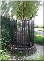
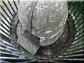
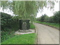
This well is dedicated to St John of Beverley, who was born in Harpham, but it may have existed long before him.
It is claimed it tames or subdues ferocious beasts and also has healing properties. It is decorated on the Tuesday nearest 7th of May and a procession from the nearby church to the well takes place.
You may be viewing yesterday's version of this page. To see the most up to date information please register for a free account.
Do not use the above information on other web sites or publications without permission of the contributor.
kelpie has found this location on Google Street View:
Nearby Images from Geograph Britain and Ireland:
©2007(licence)
©2007(licence)
©2020(licence)
©2014(licence)
©2007(licence)
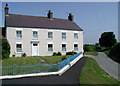
The above images may not be of the site on this page, they are loaded from Geograph.
Please Submit an Image of this site or go out and take one for us!
Click here to see more info for this site
Nearby sites
Key: Red: member's photo, Blue: 3rd party photo, Yellow: other image, Green: no photo - please go there and take one, Grey: site destroyed
Download sites to:
KML (Google Earth)
GPX (GPS waypoints)
CSV (Garmin/Navman)
CSV (Excel)
To unlock full downloads you need to sign up as a Contributory Member. Otherwise downloads are limited to 50 sites.
Turn off the page maps and other distractions
Nearby sites listing. In the following links * = Image available
1.9km W 270° Fox Hill Tumulus* Round Barrow(s) (TA07606167)
3.7km W 265° Ruston Beacon (Ruston Parva) Cairn (TA05846128)
3.9km N 1° Rudston Beacon Round Barrow* Round Barrow(s) (TA0945365617)
4.0km N 7° Rudston A Cursus* Cursus (TA099657)
4.1km N 7° Rudston Cult Centre* Ancient Village or Settlement (TA099658)
5.0km NNE 16° Southside Mount* Round Barrow(s)
5.2km WNW 295° Gallows Hill Barrow Round Barrow(s) (TA04776379)
5.4km NNW 346° Rudston B Cursus Cursus (TA081669)
5.7km N 358° Rudston Cursus Group Cursus (TA092674)
5.8km N 0° Rudston B Cursus Cursus (TA094675)
6.0km N 4° Rudston Monolith* Standing Stone (Menhir) (TA0980367743)
6.1km N 3° Rudston D Cursus Cursus (TA097678)
6.2km WSW 243° Nafferton Slack (Driffield) Standing Stone (Menhir) (TA040587)
6.3km N 8° Rudston C Cursus Cursus (TA102680)
6.4km NNW 344° Rudstone Long Barrow Long Barrow (TA07586779)
6.5km N 355° Rudston C Cursus Cursus (TA088682)
6.7km ESE 117° All Saints (Barmston)* Sculptured Stone (TA156588)
6.7km N 8° Rudston A Cursus Cursus (TA103684)
6.8km NNE 27° Caythorpe Misc. Earthwork (TA125678)
6.8km NNW 327° Kilham Long Barrow Long Barrow (TA056673)
7.0km NNE 18° Greenland Fort Hillfort (TA115684)
7.8km WNW 283° Dane's Graves* Barrow Cemetery (TA01806330)
8.3km S 185° St Elgin's Church Ancient Cross (TA090534)
8.9km N 2° Maidens Grave* Henge (TA09677063)
9.3km SE 136° Skipsea mound* Artificial Mound (TA1609455094)
View more nearby sites and additional images


 We would like to know more about this location. Please feel free to add a brief description and any relevant information in your own language.
 Wir möchten mehr über diese Stätte erfahren. Bitte zögern Sie nicht, eine kurze Beschreibung und relevante Informationen in Deutsch hinzuzufügen.
 Nous aimerions en savoir encore un peu sur les lieux. S'il vous plaît n'hesitez pas à ajouter une courte description et tous les renseignements pertinents dans votre propre langue.
 Quisieramos informarnos un poco más de las lugares. No dude en añadir una breve descripción y otros datos relevantes en su propio idioma.