

<< Our Photo Pages >> Glory Wood Bowl Barrow - Round Barrow(s) in England in Surrey
Submitted by Andy B on Thursday, 17 April 2014 Page Views: 3238
Neolithic and Bronze AgeSite Name: Glory Wood Bowl BarrowCountry: England County: Surrey Type: Round Barrow(s)
Nearest Town: Dorking
Map Ref: TQ1712248542
Latitude: 51.224065N Longitude: 0.324161W
Condition:
| 5 | Perfect |
| 4 | Almost Perfect |
| 3 | Reasonable but with some damage |
| 2 | Ruined but still recognisable as an ancient site |
| 1 | Pretty much destroyed, possibly visible as crop marks |
| 0 | No data. |
| -1 | Completely destroyed |
| 5 | Superb |
| 4 | Good |
| 3 | Ordinary |
| 2 | Not Good |
| 1 | Awful |
| 0 | No data. |
| 5 | Can be driven to, probably with disabled access |
| 4 | Short walk on a footpath |
| 3 | Requiring a bit more of a walk |
| 2 | A long walk |
| 1 | In the middle of nowhere, a nightmare to find |
| 0 | No data. |
| 5 | co-ordinates taken by GPS or official recorded co-ordinates |
| 4 | co-ordinates scaled from a detailed map |
| 3 | co-ordinates scaled from a bad map |
| 2 | co-ordinates of the nearest village |
| 1 | co-ordinates of the nearest town |
| 0 | no data |
Internal Links:
External Links:
")
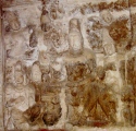
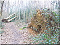
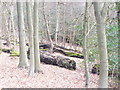
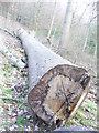
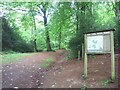
A bowl barrow situated on the crest of a hill on the southern edge of the North Downs. The barrow has an almost circular mound 18m north-south by 20m east-west and 1.3m high.
More at English Heritage
Images at
www.surreycommunity.info/friendsofdeepdene/photos/photo?photo_id=6421473
www.surreycommunity.info/friendsofdeepdene/photos/photo?photo_id=6702655
You may be viewing yesterday's version of this page. To see the most up to date information please register for a free account.
")
")
")
")
Do not use the above information on other web sites or publications without permission of the contributor.
Nearby Images from Geograph Britain and Ireland:
©2009(licence)
©2009(licence)
©2009(licence)
©2006(licence)
©2016(licence)
The above images may not be of the site on this page, they are loaded from Geograph.
Please Submit an Image of this site or go out and take one for us!
Click here to see more info for this site
Nearby sites
Key: Red: member's photo, Blue: 3rd party photo, Yellow: other image, Green: no photo - please go there and take one, Grey: site destroyed
Download sites to:
KML (Google Earth)
GPX (GPS waypoints)
CSV (Garmin/Navman)
CSV (Excel)
To unlock full downloads you need to sign up as a Contributory Member. Otherwise downloads are limited to 50 sites.
Turn off the page maps and other distractions
Nearby sites listing. In the following links * = Image available
1.9km WNW 282° Milton Heath* Round Barrow(s) (TQ15294890)
2.8km NNE 21° Box Hill Bowl Barrow 1* Round Barrow(s) (TQ18065121)
3.1km NNE 29° Box Hill Bowl Barrow 2* Round Barrow(s) (TQ18575132)
4.0km SW 222° Mag's Well (Abinger Forest)* Holy Well or Sacred Spring (TQ145455)
4.9km SSW 203° Anstiebury Camp* Hillfort (TQ1534244008)
5.3km W 265° Deerleap Wood* Round Barrow(s) (TQ118480)
6.3km NNE 13° Cherkley Court Barrows* Round Barrow(s) (TQ18385467)
6.5km WSW 246° Abinger Manor* Ancient Village or Settlement (TQ112458)
6.8km ENE 75° Reigate Heath Barrows* Barrow Cemetery (TQ23725042)
7.3km N 358° Thorncroft Spring (Leatherhead)* Holy Well or Sacred Spring (TQ167558)
7.3km SSW 213° Leith Hill Place* Natural Stone / Erratic / Other Natural Feature (TQ1324542344)
7.3km WSW 240° Felday* Hillfort (TQ10824475)
7.5km NNE 17° Thirty Acre Barn Barrows Round Barrow(s) (TQ192558)
8.6km SW 231° Holmbury Camp Hillfort (TQ105430)
9.5km E 91° Earlswood Common Barrow Cemetery Barrow Cemetery (TQ266486)
10.2km E 82° Waterslade Spring Holy Well or Sacred Spring (TQ272502)
10.3km E 83° Whitepost Hill Spring Holy Well or Sacred Spring (TQ273501)
10.3km E 85° Redhill Common* Round Barrow(s) (TQ274496)
10.8km ENE 69° Gatton Park, The Millennium Stones* Modern Stone Circle etc (TQ271527)
10.9km W 265° Albury Park Mound* Round Barrow(s) (TQ062474)
11.0km NE 53° St. Margaret's Well (Mugswell)* Holy Well or Sacred Spring (TQ258553)
11.0km W 272° The Silent Pool* Holy Well or Sacred Spring (TQ0606148582)
11.1km E 90° Royal Earlswood Stones* Modern Stone Circle etc (TQ283487)
11.4km W 271° Weston Woods Cromlech* Standing Stones (TQ05644839)
11.5km N 4° Ashtead Common Earthwork* Misc. Earthwork (TQ176600)
View more nearby sites and additional images


 We would like to know more about this location. Please feel free to add a brief description and any relevant information in your own language.
 Wir möchten mehr über diese Stätte erfahren. Bitte zögern Sie nicht, eine kurze Beschreibung und relevante Informationen in Deutsch hinzuzufügen.
 Nous aimerions en savoir encore un peu sur les lieux. S'il vous plaît n'hesitez pas à ajouter une courte description et tous les renseignements pertinents dans votre propre langue.
 Quisieramos informarnos un poco más de las lugares. No dude en añadir una breve descripción y otros datos relevantes en su propio idioma.