

<< Our Photo Pages >> Dolmen de Santa Elena - Burial Chamber or Dolmen in Spain in Aragón
Submitted by AlexHunger on Saturday, 02 August 2008 Page Views: 4103
Neolithic and Bronze AgeSite Name: Dolmen de Santa ElenaCountry: Spain
NOTE: This site is 16.347 km away from the location you searched for.
Region: Aragón Type: Burial Chamber or Dolmen
Nearest Town: Biescas Nearest Village: Gavín
Latitude: 42.659315N Longitude: 0.318407W
Condition:
| 5 | Perfect |
| 4 | Almost Perfect |
| 3 | Reasonable but with some damage |
| 2 | Ruined but still recognisable as an ancient site |
| 1 | Pretty much destroyed, possibly visible as crop marks |
| 0 | No data. |
| -1 | Completely destroyed |
| 5 | Superb |
| 4 | Good |
| 3 | Ordinary |
| 2 | Not Good |
| 1 | Awful |
| 0 | No data. |
| 5 | Can be driven to, probably with disabled access |
| 4 | Short walk on a footpath |
| 3 | Requiring a bit more of a walk |
| 2 | A long walk |
| 1 | In the middle of nowhere, a nightmare to find |
| 0 | No data. |
| 5 | co-ordinates taken by GPS or official recorded co-ordinates |
| 4 | co-ordinates scaled from a detailed map |
| 3 | co-ordinates scaled from a bad map |
| 2 | co-ordinates of the nearest village |
| 1 | co-ordinates of the nearest town |
| 0 | no data |
Internal Links:
External Links:
I have visited· I would like to visit
DrewParsons SolarMegalith would like to visit
")
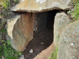
Classic Dolmen consisting of only 2 uprights and one capstone on the side of a hill.
You may be viewing yesterday's version of this page. To see the most up to date information please register for a free account.
")
Do not use the above information on other web sites or publications without permission of the contributor.
Nearby Images from Flickr

The above images may not be of the site on this page, but were taken nearby. They are loaded from Flickr so please click on them for image credits.
Click here to see more info for this site
Nearby sites
Click here to view sites on an interactive map of the areaKey: Red: member's photo, Blue: 3rd party photo, Yellow: other image, Green: no photo - please go there and take one, Grey: site destroyed
Download sites to:
KML (Google Earth)
GPX (GPS waypoints)
CSV (Garmin/Navman)
CSV (Excel)
To unlock full downloads you need to sign up as a Contributory Member. Otherwise downloads are limited to 50 sites.
Turn off the page maps and other distractions
Nearby sites listing. In the following links * = Image available
5.2km NW 324° Ibón De Piedrafita Túmulo* Round Barrow(s)
5.2km NNW 341° Las Lastras Chromlech* Stone Circle
6.1km NE 49° Ibón De Sabocos Dolmen Burial Chamber or Dolmen
7.5km NNW 329° La Paúl Túmulo Round Barrow(s)
8.5km NW 310° O Goluso Dolmen* Burial Chamber or Dolmen
8.5km NNW 329° Ibón De Tramacastilla Chromlech* Stone Circle
8.8km NNW 330° Lordeci Túmulo* Round Barrow(s)
8.8km NNW 330° Lordeci Sur Chromlech* Stone Circle
8.9km NNW 330° Lordeci Dolmen Burial Chamber or Dolmen
8.9km NNW 330° Lordeci Norte Chromlech* Stone Circle
9.5km NNW 332° El Puente Túmulo Round Barrow(s)
9.6km NNW 332° El Salero Chromlech Stone Circle
9.7km NW 311° Plan De Blasco Chromlech Stone Circle
9.7km NNW 332° El Puente Dolmen Burial Chamber or Dolmen
9.7km NNW 333° El Puente Chromlech Stone Circle
10.0km NNW 327° Pocetas De La Cambra Chromlech Stone Circle
10.2km NNW 328° Carrusco Túmulo Round Barrow(s)
10.7km NNW 331° El Bozuelo Túmulo Round Barrow(s)
10.8km NNW 332° Hoya Serpena Chromlech Stone Circle
10.9km NW 305° Arbenuso Chromlech Stone Circle
11.2km NW 323° Zarrambucho Túmulo Round Barrow(s)
11.3km NNW 326° La Catarreta Túmulo Round Barrow(s)
11.3km NW 322° La Balsera Chromlech* Stone Circle
11.3km NW 325° La Catarreta Chromlech Stone Circle
11.7km NW 319° Cantal De Balsera Túmulo Round Barrow(s)
View more nearby sites and additional images


 We would like to know more about this location. Please feel free to add a brief description and any relevant information in your own language.
 Wir möchten mehr über diese Stätte erfahren. Bitte zögern Sie nicht, eine kurze Beschreibung und relevante Informationen in Deutsch hinzuzufügen.
 Nous aimerions en savoir encore un peu sur les lieux. S'il vous plaît n'hesitez pas à ajouter une courte description et tous les renseignements pertinents dans votre propre langue.
 Quisieramos informarnos un poco más de las lugares. No dude en añadir una breve descripción y otros datos relevantes en su propio idioma.