


<< Our Photo Pages >> Filey Roman Signal Station - Ancient Village or Settlement in England in Yorkshire (North)
Submitted by cactus_chris on Tuesday, 08 November 2022 Page Views: 821
Roman, Greek and ClassicalSite Name: Filey Roman Signal StationCountry: England
NOTE: This site is 2.152 km away from the location you searched for.
County: Yorkshire (North) Type: Ancient Village or Settlement
Nearest Town: Filey
Map Ref: TA1187080412
Latitude: 54.207251N Longitude: 0.28629W
Condition:
| 5 | Perfect |
| 4 | Almost Perfect |
| 3 | Reasonable but with some damage |
| 2 | Ruined but still recognisable as an ancient site |
| 1 | Pretty much destroyed, possibly visible as crop marks |
| 0 | No data. |
| -1 | Completely destroyed |
| 5 | Superb |
| 4 | Good |
| 3 | Ordinary |
| 2 | Not Good |
| 1 | Awful |
| 0 | No data. |
| 5 | Can be driven to, probably with disabled access |
| 4 | Short walk on a footpath |
| 3 | Requiring a bit more of a walk |
| 2 | A long walk |
| 1 | In the middle of nowhere, a nightmare to find |
| 0 | No data. |
| 5 | co-ordinates taken by GPS or official recorded co-ordinates |
| 4 | co-ordinates scaled from a detailed map |
| 3 | co-ordinates scaled from a bad map |
| 2 | co-ordinates of the nearest village |
| 1 | co-ordinates of the nearest town |
| 0 | no data |
Internal Links:
External Links:
I have visited· I would like to visit
cactus_chris visited on 21st Sep 2021 - their rating: Cond: 5 Amb: 5 Access: 5
")
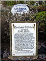
It was manned by a small garrison of soldiers, with the rocky ‘spittal’ (mooring place) below the cliffs being used as a natural harbour for Roman sailing vessels.
More: https://thejournalofantiquities.com/category/filey-roman-signal-station/
You may be viewing yesterday's version of this page. To see the most up to date information please register for a free account.
")
Do not use the above information on other web sites or publications without permission of the contributor.
Nearby Images from Geograph Britain and Ireland:
©2010(licence)
©2010(licence)
©2010(licence)
©2012(licence)
©2010(licence)
The above images may not be of the site on this page, they are loaded from Geograph.
Please Submit an Image of this site or go out and take one for us!
Click here to see more info for this site
Nearby sites
Key: Red: member's photo, Blue: 3rd party photo, Yellow: other image, Green: no photo - please go there and take one, Grey: site destroyed
Download sites to:
KML (Google Earth)
GPX (GPS waypoints)
CSV (Garmin/Navman)
CSV (Excel)
To unlock full downloads you need to sign up as a Contributory Member. Otherwise downloads are limited to 50 sites.
Turn off the page maps and other distractions
Nearby sites listing. In the following links * = Image available
708m NNW 348° Sailors' Well* Holy Well or Sacred Spring (TA117811)
1.5km NE 38° Carr Naze (Filey) Misc. Earthwork (TA1275581605)
1.7km ENE 59° Spittals, Filey Brigg* Rock Outcrop (TA133813)
3.8km NW 319° Gristhorpe Tumuli* Round Barrow(s) (TA093832)
5.4km SSE 165° Knox Well* Holy Well or Sacred Spring (TA134752)
5.5km WSW 254° Spell Howe (Folkton) Cairn (TA06577878)
6.5km WSW 248° Folkton Round Barrow* Round Barrow(s) (TA059778)
7.5km WSW 250° Sharp Howes* Barrow Cemetery (TA049777)
8.3km WSW 249° Elf Howe Round Barrow(s) (TA04227725)
8.7km SSW 192° Rudston D Cursus Cursus (TA102719)
9.0km W 275° Star Carr* Ancient Village or Settlement (TA0282181013)
9.1km S 176° Keld Spring* Holy Well or Sacred Spring (TA128714)
9.6km WNW 293° Crossgates Stone (Seamer) Natural Stone / Erratic / Other Natural Feature (TA02948398)
9.9km SW 217° Willy Howe* Round Barrow(s) (TA06167235)
9.9km WSW 246° Willerby Wold Long Barrow Long Barrow (TA029761)
10.0km SSW 194° Maidens Grave* Henge (TA09677063)
10.5km SW 226° Wold Newton* Round Barrow(s) (TA04527287)
10.5km SW 223° Ba’l Hill* Round Barrow(s) (TA048726)
10.6km SE 141° Bempton Stones* Marker Stone (TA18737226)
10.9km NW 318° Rotunda Museum* Museum (TA0432588255)
11.0km NW 324° Our Lady's Well (Scarborough)* Holy Well or Sacred Spring (TA051891)
11.1km WSW 250° Willerby Wold House* Round Barrow(s) (TA015763)
11.5km NW 310° Falsgrave Park Circle* Modern Stone Circle etc (TA028876)
12.0km S 183° Greenland Fort Hillfort (TA115684)
12.1km S 189° Rudston A Cursus Cursus (TA103684)
View more nearby sites and additional images


 We would like to know more about this location. Please feel free to add a brief description and any relevant information in your own language.
 Wir möchten mehr über diese Stätte erfahren. Bitte zögern Sie nicht, eine kurze Beschreibung und relevante Informationen in Deutsch hinzuzufügen.
 Nous aimerions en savoir encore un peu sur les lieux. S'il vous plaît n'hesitez pas à ajouter une courte description et tous les renseignements pertinents dans votre propre langue.
 Quisieramos informarnos un poco más de las lugares. No dude en añadir una breve descripción y otros datos relevantes en su propio idioma.