

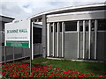
<< Other Photo Pages >> Bourne Hall Museum - Museum in England in Surrey
Submitted by Andy B on Friday, 04 May 2007 Page Views: 5134
MuseumsSite Name: Bourne Hall MuseumCountry: England
NOTE: This site is 2.882 km away from the location you searched for.
County: Surrey Type: Museum
Map Ref: TQ218627
Latitude: 51.350334N Longitude: 0.25238W
Condition:
| 5 | Perfect |
| 4 | Almost Perfect |
| 3 | Reasonable but with some damage |
| 2 | Ruined but still recognisable as an ancient site |
| 1 | Pretty much destroyed, possibly visible as crop marks |
| 0 | No data. |
| -1 | Completely destroyed |
| 5 | Superb |
| 4 | Good |
| 3 | Ordinary |
| 2 | Not Good |
| 1 | Awful |
| 0 | No data. |
| 5 | Can be driven to, probably with disabled access |
| 4 | Short walk on a footpath |
| 3 | Requiring a bit more of a walk |
| 2 | A long walk |
| 1 | In the middle of nowhere, a nightmare to find |
| 0 | No data. |
| 5 | co-ordinates taken by GPS or official recorded co-ordinates |
| 4 | co-ordinates scaled from a detailed map |
| 3 | co-ordinates scaled from a bad map |
| 2 | co-ordinates of the nearest village |
| 1 | co-ordinates of the nearest town |
| 0 | no data |
Internal Links:
External Links:
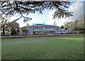
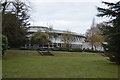
Museum in Surrey. Entering Bourne Hall, you look up to the mezzanine floor to see a museum. The galleries, which are open plan, lie underneath the transparent dome which crowns the building.
Displays draw on a collection of over five thousand items acquired over the years through the generosity of local people.
The museum is run by the Borough of Epsom and Ewell and admission is free.
The Curator is Jeremy Harte, who will be well known to Folklorists and 3rd Stone readers.
More: Epsom Townpage
Surrey Museums
You may be viewing yesterday's version of this page. To see the most up to date information please register for a free account.
Do not use the above information on other web sites or publications without permission of the contributor.
Andy B has found this location on Google Street View:
Nearby Images from Geograph Britain and Ireland:
©2009(licence)
©2018(licence)
©2018(licence)
©2010(licence)
©2012(licence)
The above images may not be of the site on this page, they are loaded from Geograph.
Please Submit an Image of this site or go out and take one for us!
Click here to see more info for this site
Nearby sites
Key: Red: member's photo, Blue: 3rd party photo, Yellow: other image, Green: no photo - please go there and take one, Grey: site destroyed
Download sites to:
KML (Google Earth)
GPX (GPS waypoints)
CSV (Garmin/Navman)
CSV (Excel)
To unlock full downloads you need to sign up as a Contributory Member. Otherwise downloads are limited to 50 sites.
Turn off the page maps and other distractions
Nearby sites listing. In the following links * = Image available
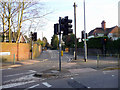
100m E 91° Ewell Springs (Surrey)* Holy Well or Sacred Spring (TQ219627)
537m ESE 113° Hatch Furlong Ritual Shafts* Misc. Earthwork (TQ223625)
3.7km SE 124° Gally Hills Barrow Cemetery (TQ249607)
5.0km WSW 239° Ashtead Common Earthwork* Misc. Earthwork (TQ176600)
5.4km NNE 31° Morden Park* Artificial Mound (TQ245674)
6.3km ENE 75° Queen Anne's Well (Carshalton)* Holy Well or Sacred Spring (TQ279645)
7.4km SSW 202° Thirty Acre Barn Barrows Round Barrow(s) (TQ192558)
7.4km NNW 333° Kingston Museum* Museum (TQ1830169219)
7.5km NNW 330° King Stone (Kingston-upon-Thames)* Marker Stone (TQ1786769069)
8.4km SE 136° Chipstead Well Holy Well or Sacred Spring (TQ278568)
8.4km SSE 153° St. Margaret's Well (Mugswell)* Holy Well or Sacred Spring (TQ258553)
8.4km NNW 346° King Clump Artificial Mound (TQ195708)
8.4km N 5° Caesar's Camp (Wimbledon)* Hillfort (TQ224711)
8.6km SW 218° Thorncroft Spring (Leatherhead)* Holy Well or Sacred Spring (TQ167558)
8.7km SSW 204° Cherkley Court Barrows* Round Barrow(s) (TQ18385467)
8.8km N 5° Caesar's Well (Wimbledon) Holy Well or Sacred Spring (TQ22377151)
9.4km NW 326° Barrow Hill (Teddington)* Round Barrow(s) (TQ16287037)
9.5km ESE 122° Farthing Downs* Barrow Cemetery (TQ300578)
9.8km NNW 344° Richmond Park Long Barrow Artificial Mound (TQ189721)
10.3km N 7° Putney Heath Round Barrow(s) (TQ22797295)
10.4km NE 56° Pollards Hill Hillfort (TQ303688)
10.7km ESE 103° Riddlesdown Newe Ditch* Misc. Earthwork (TQ3230460572)
10.9km NNW 344° King Henry's Mound* Artificial Mound (TQ18607315)
11.3km SSE 154° Gatton Park, The Millennium Stones* Modern Stone Circle etc (TQ271527)
11.4km SE 129° St Peter and St Paul's Church (Chaldon)* Ancient Cross (TQ3087455694)
View more nearby sites and additional images


 We would like to know more about this location. Please feel free to add a brief description and any relevant information in your own language.
 Wir möchten mehr über diese Stätte erfahren. Bitte zögern Sie nicht, eine kurze Beschreibung und relevante Informationen in Deutsch hinzuzufügen.
 Nous aimerions en savoir encore un peu sur les lieux. S'il vous plaît n'hesitez pas à ajouter une courte description et tous les renseignements pertinents dans votre propre langue.
 Quisieramos informarnos un poco más de las lugares. No dude en añadir una breve descripción y otros datos relevantes en su propio idioma.