


<< Our Photo Pages >> Lud well (Stainton-Le-Vale) - Holy Well or Sacred Spring in England in Lincolnshire
Submitted by HOLYWELL on Saturday, 16 February 2008 Page Views: 17803
Springs and Holy WellsSite Name: Lud well (Stainton-Le-Vale)Country: England County: Lincolnshire Type: Holy Well or Sacred Spring
Nearest Village: Stainto-Le-Vale
Map Ref: TF17629376
Latitude: 53.427521N Longitude: 0.231267W
Condition:
| 5 | Perfect |
| 4 | Almost Perfect |
| 3 | Reasonable but with some damage |
| 2 | Ruined but still recognisable as an ancient site |
| 1 | Pretty much destroyed, possibly visible as crop marks |
| 0 | No data. |
| -1 | Completely destroyed |
| 5 | Superb |
| 4 | Good |
| 3 | Ordinary |
| 2 | Not Good |
| 1 | Awful |
| 0 | No data. |
| 5 | Can be driven to, probably with disabled access |
| 4 | Short walk on a footpath |
| 3 | Requiring a bit more of a walk |
| 2 | A long walk |
| 1 | In the middle of nowhere, a nightmare to find |
| 0 | No data. |
| 5 | co-ordinates taken by GPS or official recorded co-ordinates |
| 4 | co-ordinates scaled from a detailed map |
| 3 | co-ordinates scaled from a bad map |
| 2 | co-ordinates of the nearest village |
| 1 | co-ordinates of the nearest town |
| 0 | no data |
Internal Links:
External Links:
 (PID:37583)")
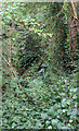
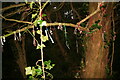
This is a very evocative site. It requires a bit of scramble down some steepish slopes into a wooded copse. It is unclear the access rights but it appears well trod.
The spring arises in a small cave like structure and fills a small pool. When I saw it in the summer it was a bit dry but apparently it forms a small waterfall according to local sources. The origin of the name is believed to come from Hlud meaning loud but again as always it is possible to think that the site may be derived from Celtic deity Lud.
You may be viewing yesterday's version of this page. To see the most up to date information please register for a free account.
 (PID:37585)")
 (PID:37584)")
Do not use the above information on other web sites or publications without permission of the contributor.
Nearby Images from Geograph Britain and Ireland:
©2009(licence)
©2013(licence)
©2023(licence)
©2009(licence)
©2015(licence)
The above images may not be of the site on this page, they are loaded from Geograph.
Please Submit an Image of this site or go out and take one for us!
Click here to see more info for this site
Nearby sites
Key: Red: member's photo, Blue: 3rd party photo, Yellow: other image, Green: no photo - please go there and take one, Grey: site destroyed
Download sites to:
KML (Google Earth)
GPX (GPS waypoints)
CSV (Garmin/Navman)
CSV (Excel)
To unlock full downloads you need to sign up as a Contributory Member. Otherwise downloads are limited to 50 sites.
Turn off the page maps and other distractions
Nearby sites listing. In the following links * = Image available
1.5km SSW 195° Bully Hill (Tealby)* Round Barrow(s) (TF17279227)
4.0km NE 55° Ash Hill Long Barrow* Long Barrow (TF20889612)
4.0km WSW 251° Walesby All Saints church carvings* Sculptured Stone (TF1382892388)
4.2km ENE 70° Hoe Hill Long Barrow* Long Barrow (TF215953)
5.0km WNW 303° Hills Brough* Long Barrow (TF1337396415)
7.5km NNE 12° Ash Holt Long Barrow* Long Barrow (TA1898001112)
8.8km SE 142° Grims Mound* Round Barrow(s) (TF23258693)
9.5km NW 323° Syfer Spring Holy Well or Sacred Spring (TA117012)
9.5km NW 323° Holy Well (Caistor) Holy Well or Sacred Spring (TA1172501229)
9.5km SSE 159° Burgh on Bain* Long Barrow (TF21298497)
10.4km SSE 160° Burgh Top* Round Barrow(s) (TF21458406)
10.9km NNW 332° Fonaby Stone* Standing Stones (TA123033)
13.2km SW 220° Wickenby Ancient Village or Settlement (TF0928883432)
15.0km NNW 327° Holy Wells (Barnetby le Wold) Holy Well or Sacred Spring (TA091061)
15.0km WNW 302° Maiden Well (Maidenwell) Holy Well or Sacred Spring (TA047015)
15.2km WNW 302° The Maiden-Well Holy Well or Sacred Spring (TA045015)
15.7km NNW 346° Brocklesby Park (Great Limber) Cairn (TA1332708902)
16.0km N 10° Ragged Spring (Healing) Holy Well or Sacred Spring (TA199096)
16.5km SE 136° Tathwell Long Barrow* Long Barrow (TF29458225)
16.7km NNE 27° Toot Hill Round Barrow* Round Barrow(s) (TA24800888)
16.8km NNE 15° Toot Hill Bowl Barrow Round Barrow(s) (TA21601011)
18.9km NE 42° Beacon Hill Barrow (Cleethorpes)* Round Barrow(s) (TA2994408098)
19.0km SE 127° Bully Hills* Barrow Cemetery (TF33128272)
19.9km W 260° Newell's Well (Glentham) Holy Well or Sacred Spring (SK981897)
20.6km NNW 334° Yarborough Camp Hillfort (TA081120)
View more nearby sites and additional images


 We would like to know more about this location. Please feel free to add a brief description and any relevant information in your own language.
 Wir möchten mehr über diese Stätte erfahren. Bitte zögern Sie nicht, eine kurze Beschreibung und relevante Informationen in Deutsch hinzuzufügen.
 Nous aimerions en savoir encore un peu sur les lieux. S'il vous plaît n'hesitez pas à ajouter une courte description et tous les renseignements pertinents dans votre propre langue.
 Quisieramos informarnos un poco más de las lugares. No dude en añadir una breve descripción y otros datos relevantes en su propio idioma.