


<< Our Photo Pages >> All Saints (Barmston) - Sculptured Stone in England in Yorkshire (East)
Submitted by Sunny100 on Saturday, 16 July 2011 Page Views: 5956
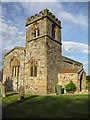
Multi-periodSite Name: All Saints (Barmston) Alternative Name: The Barmston Hogback StoneCountry: England
NOTE: This site is 2.297 km away from the location you searched for.
County: Yorkshire (East) Type: Sculptured Stone
Nearest Town: Bridlington Nearest Village: Barmston
Map Ref: TA156588
Latitude: 54.012279N Longitude: 0.237386W
Condition:
| 5 | Perfect |
| 4 | Almost Perfect |
| 3 | Reasonable but with some damage |
| 2 | Ruined but still recognisable as an ancient site |
| 1 | Pretty much destroyed, possibly visible as crop marks |
| 0 | No data. |
| -1 | Completely destroyed |
| 5 | Superb |
| 4 | Good |
| 3 | Ordinary |
| 2 | Not Good |
| 1 | Awful |
| 0 | No data. |
| 5 | Can be driven to, probably with disabled access |
| 4 | Short walk on a footpath |
| 3 | Requiring a bit more of a walk |
| 2 | A long walk |
| 1 | In the middle of nowhere, a nightmare to find |
| 0 | No data. |
| 5 | co-ordinates taken by GPS or official recorded co-ordinates |
| 4 | co-ordinates scaled from a detailed map |
| 3 | co-ordinates scaled from a bad map |
| 2 | co-ordinates of the nearest village |
| 1 | co-ordinates of the nearest town |
| 0 | no data |
Internal Links:
External Links:
 (PID:252014)")
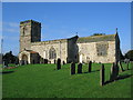
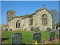
All Saints church at Barmston is located east of the A165 road some 6 miles south of Bridlington - at the west side of the village along Sands Lane and then just down the track leading southwards for a short distance.
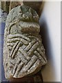
In the porch stands part of a 9th-10th century sandstone hogback tomb that has some Anglo/Norse carvings. This piece of stone was housed in the rectory until 1996. Many of these richly carved hogback tomb stones are usually dated to AD 875-1066.
You may be viewing yesterday's version of this page. To see the most up to date information please register for a free account.
 (PID:252015)")
Do not use the above information on other web sites or publications without permission of the contributor.
Nearby Images from Geograph Britain and Ireland:
©2005(licence)
©2008(licence)
©2013(licence)
©2009(licence)
©2013(licence)
The above images may not be of the site on this page, they are loaded from Geograph.
Please Submit an Image of this site or go out and take one for us!
Click here to see more info for this site
Nearby sites
Key: Red: member's photo, Blue: 3rd party photo, Yellow: other image, Green: no photo - please go there and take one, Grey: site destroyed
Download sites to:
KML (Google Earth)
GPX (GPS waypoints)
CSV (Garmin/Navman)
CSV (Excel)
To unlock full downloads you need to sign up as a Contributory Member. Otherwise downloads are limited to 50 sites.
Turn off the page maps and other distractions
Nearby sites listing. In the following links * = Image available
3.7km S 174° Skipsea mound* Artificial Mound (TA1609455094)
6.7km WNW 297° St John's Well (Harpham)* Holy Well or Sacred Spring (TA095617)
8.5km WNW 291° Fox Hill Tumulus* Round Barrow(s) (TA07606167)
8.5km SW 232° St Elgin's Church Ancient Cross (TA090534)
8.9km NW 322° Rudston A Cursus* Cursus (TA099657)
9.0km NW 322° Rudston Cult Centre* Ancient Village or Settlement (TA099658)
9.2km NNW 330° Southside Mount* Round Barrow(s)
9.2km NW 319° Rudston Beacon Round Barrow* Round Barrow(s) (TA0945365617)
9.5km NNW 342° Caythorpe Misc. Earthwork (TA125678)
10.0km WNW 286° Ruston Beacon (Ruston Parva) Cairn (TA05846128)
10.4km NNW 338° Greenland Fort Hillfort (TA115684)
10.6km NNW 329° Rudston Monolith* Standing Stone (Menhir) (TA0980367743)
10.7km NNW 331° Rudston C Cursus Cursus (TA102680)
10.7km NW 326° Rudston B Cursus Cursus (TA094675)
10.7km NW 325° Rudston Cursus Group Cursus (TA092674)
10.7km NNW 328° Rudston D Cursus Cursus (TA097678)
11.0km NNW 333° Rudston A Cursus Cursus (TA103684)
11.0km NW 319° Rudston B Cursus Cursus (TA081669)
11.6km W 271° Nafferton Slack (Driffield) Standing Stone (Menhir) (TA040587)
11.6km NW 326° Rudston C Cursus Cursus (TA088682)
11.9km WNW 296° Gallows Hill Barrow Round Barrow(s) (TA04776379)
12.0km NW 320° Rudstone Long Barrow Long Barrow (TA07586779)
12.4km NNE 29° Gell Spring* Holy Well or Sacred Spring (TA213698)
12.9km N 349° Keld Spring* Holy Well or Sacred Spring (TA128714)
13.1km NW 312° Kilham Long Barrow Long Barrow (TA056673)
View more nearby sites and additional images

")
 We would like to know more about this location. Please feel free to add a brief description and any relevant information in your own language.
 Wir möchten mehr über diese Stätte erfahren. Bitte zögern Sie nicht, eine kurze Beschreibung und relevante Informationen in Deutsch hinzuzufügen.
 Nous aimerions en savoir encore un peu sur les lieux. S'il vous plaît n'hesitez pas à ajouter une courte description et tous les renseignements pertinents dans votre propre langue.
 Quisieramos informarnos un poco más de las lugares. No dude en añadir una breve descripción y otros datos relevantes en su propio idioma.