


<< Our Photo Pages >> Le Megalithe de Picampeau a Lussac - Rock Art in France in Aquitaine:Gironde (33)
Submitted by oldman on Friday, 21 September 2018 Page Views: 1210
Rock ArtSite Name: Le Megalithe de Picampeau a LussacCountry: France
NOTE: This site is 12.463 km away from the location you searched for.
Département: Aquitaine:Gironde (33) Type: Rock Art
Nearest Village: Lussac
Latitude: 44.943930N Longitude: 0.105739W
Condition:
| 5 | Perfect |
| 4 | Almost Perfect |
| 3 | Reasonable but with some damage |
| 2 | Ruined but still recognisable as an ancient site |
| 1 | Pretty much destroyed, possibly visible as crop marks |
| 0 | No data. |
| -1 | Completely destroyed |
| 5 | Superb |
| 4 | Good |
| 3 | Ordinary |
| 2 | Not Good |
| 1 | Awful |
| 0 | No data. |
| 5 | Can be driven to, probably with disabled access |
| 4 | Short walk on a footpath |
| 3 | Requiring a bit more of a walk |
| 2 | A long walk |
| 1 | In the middle of nowhere, a nightmare to find |
| 0 | No data. |
| 5 | co-ordinates taken by GPS or official recorded co-ordinates |
| 4 | co-ordinates scaled from a detailed map |
| 3 | co-ordinates scaled from a bad map |
| 2 | co-ordinates of the nearest village |
| 1 | co-ordinates of the nearest town |
| 0 | no data |
Internal Links:
External Links:
I have visited· I would like to visit
PERKYPUFFIN would like to visit
")
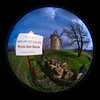
The coordinates are taken from an app on my phone. It is difficult to read the sign in the village pointing you to "Megalithic" but then nothing until the post 40m out. It's a short walk if you have the persistence to drive along a dirt track to a pile of stones that look like a tumbled Dolmen. The stone is vast and probably broken off from above but clearly has been worked by man. Whether this should be classified as rock art or sculptured stone I don't know.
You may be viewing yesterday's version of this page. To see the most up to date information please register for a free account.
")
")
")
Do not use the above information on other web sites or publications without permission of the contributor.
Nearby Images from Flickr


The above images may not be of the site on this page, but were taken nearby. They are loaded from Flickr so please click on them for image credits.
Click here to see more info for this site
Nearby sites
Click here to view sites on an interactive map of the areaKey: Red: member's photo, Blue: 3rd party photo, Yellow: other image, Green: no photo - please go there and take one, Grey: site destroyed
Download sites to:
KML (Google Earth)
GPX (GPS waypoints)
CSV (Garmin/Navman)
CSV (Excel)
To unlock full downloads you need to sign up as a Contributory Member. Otherwise downloads are limited to 50 sites.
Turn off the page maps and other distractions
Nearby sites listing. In the following links * = Image available
7.3km ESE 111° Peyre Lebade* Standing Stone (Menhir)
7.8km SE 130° Pitray Allée couverte* Passage Grave
7.9km ESE 115° Dolmen de Puy Landry* Burial Chamber or Dolmen
7.9km ESE 114° Menhir de Clotte Standing Stone (Menhir)
8.1km ESE 108° Pierre Levée (Salles-de-Castillon)* Standing Stone (Menhir)
9.9km SW 232° Peyrefitte* Standing Stone (Menhir)
11.5km WSW 253° Menhir de Carré Standing Stone (Menhir)
15.2km NE 55° Menhir du Pizou* Standing Stone (Menhir)
17.4km W 273° Abri de Saint-Germain-la-Rivière Cave or Rock Shelter
19.5km SSW 192° Curton Dolmen* Burial Chamber or Dolmen
19.8km SSW 195° Sabatey Dolmen 1* Burial Chamber or Dolmen
19.8km SSW 195° Sabatey Dolmen 2* Burial Chamber or Dolmen
20.0km SE 133° Abri du Morin Cave or Rock Shelter
20.2km SSW 193° Pierre du Maine du Prieuré * Standing Stone (Menhir)
20.5km SW 214° Allée Couverte de Lafut Passage Grave
21.1km SSW 213° Allée Couverte de Ligarde Passage Grave
21.4km SW 219° Gisement de Camiac Cave or Rock Shelter
21.5km SSE 161° Menhir dit la Gran'Boyne de Balette* Standing Stone (Menhir)
21.9km SSW 191° Gisement de Grand-Moulin Cave or Rock Shelter
21.9km E 98° Dolmen Pierre Plantade* Burial Chamber or Dolmen
22.0km SSW 193° Roquefort Allée couverte* Passage Grave
22.1km S 187° Pontaret Menhir* Standing Stone (Menhir)
22.3km SSW 194° Roquefort Settlement Ancient Village or Settlement
22.4km S 179° Menhir Notre Dame de Bonne Nouvelle* Standing Stone (Menhir)
22.5km SSE 168° Dolmen de la Mouleyre Burial Chamber or Dolmen
View more nearby sites and additional images


 We would like to know more about this location. Please feel free to add a brief description and any relevant information in your own language.
 Wir möchten mehr über diese Stätte erfahren. Bitte zögern Sie nicht, eine kurze Beschreibung und relevante Informationen in Deutsch hinzuzufügen.
 Nous aimerions en savoir encore un peu sur les lieux. S'il vous plaît n'hesitez pas à ajouter une courte description et tous les renseignements pertinents dans votre propre langue.
 Quisieramos informarnos un poco más de las lugares. No dude en añadir una breve descripción y otros datos relevantes en su propio idioma.