 with our Megalithic Portal iPhone app")

<< Text Pages >> Site archéologique (Orne) - Museum in France in Normandie:Orne (61)
Submitted by t4t35 on Saturday, 16 April 2005 Page Views: 2595
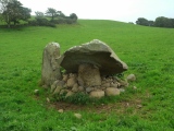
MuseumsSite Name: Site archéologique (Orne)Country: France
NOTE: This site is 3.631 km away from the location you searched for.
Département: Normandie:Orne (61) Type: Museum
Nearest Town: La Ferté-Macé Nearest Village: Le Champ-de-la-Pierr
Latitude: 48.611260N Longitude: 0.21537W
Condition:
| 5 | Perfect |
| 4 | Almost Perfect |
| 3 | Reasonable but with some damage |
| 2 | Ruined but still recognisable as an ancient site |
| 1 | Pretty much destroyed, possibly visible as crop marks |
| 0 | No data. |
| -1 | Completely destroyed |
| 5 | Superb |
| 4 | Good |
| 3 | Ordinary |
| 2 | Not Good |
| 1 | Awful |
| 0 | No data. |
| 5 | Can be driven to, probably with disabled access |
| 4 | Short walk on a footpath |
| 3 | Requiring a bit more of a walk |
| 2 | A long walk |
| 1 | In the middle of nowhere, a nightmare to find |
| 0 | No data. |
| 5 | co-ordinates taken by GPS or official recorded co-ordinates |
| 4 | co-ordinates scaled from a detailed map |
| 3 | co-ordinates scaled from a bad map |
| 2 | co-ordinates of the nearest village |
| 1 | co-ordinates of the nearest town |
| 0 | no data |
Be the first person to rate this site - see the 'Contribute!' box in the right hand menu.
Internal Links:
External Links:
Museum in Orne
More at MUSI
IMPORTANT NOTE: Site believed to be near this position
You may be viewing yesterday's version of this page. To see the most up to date information please register for a free account.
Do not use the above information on other web sites or publications without permission of the contributor.
Nearby Images from Flickr


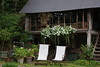
The above images may not be of the site on this page, but were taken nearby. They are loaded from Flickr so please click on them for image credits.
Click here to see more info for this site
Nearby sites
Click here to view sites on an interactive map of the areaKey: Red: member's photo, Blue: 3rd party photo, Yellow: other image, Green: no photo - please go there and take one, Grey: site destroyed
Download sites to:
KML (Google Earth)
GPX (GPS waypoints)
CSV (Garmin/Navman)
CSV (Excel)
To unlock full downloads you need to sign up as a Contributory Member. Otherwise downloads are limited to 50 sites.
Turn off the page maps and other distractions
Nearby sites listing. In the following links * = Image available
3.5km SW 217° Dolmen dit de la Grandière* Burial Chamber or Dolmen
3.5km SSW 205° Menhir d'Outres* Standing Stone (Menhir)
4.4km SSW 210° Dolmen dit la Pierre aux Loups Burial Chamber or Dolmen
11.2km E 94° Camp de Goult Ancient Village or Settlement
14.3km N 7° Vieux Chateaux Ancient Village or Settlement
14.8km N 1° Menhir de la Courbe* Standing Stone (Menhir)
15.0km N 8° Camp du Bas de la Courbe Ancient Village or Settlement
15.3km N 9° La Courbe Burial Chamber or Dolmen
15.3km N 9° La Pierre Tournoire, La Courbe* Standing Stone (Menhir)
15.8km E 96° Pierre de la Tremblaie Standing Stone (Menhir)
15.9km N 357° Crève-Coeur Menhir Standing Stone (Menhir)
16.3km W 276° La Bertinière* Passage Grave
17.4km E 88° Dolmen de la Pierre Tournoire (Montmerrei) Burial Chamber or Dolmen
17.9km NE 46° Sarceaux burial chamber Burial Chamber or Dolmen
18.2km NNW 332° Dolmen de la Cardotière Burial Chamber or Dolmen
18.7km NNW 332° La Table des Fées, Chêneduit* Burial Chamber or Dolmen
18.9km WSW 255° Dolmen dit le Lit de la Gione* Burial Chamber or Dolmen
19.3km NNW 327° L'Affiloire de Gargantua* Standing Stone (Menhir)
20.8km NE 37° Moulins-sur-Orne burial chamber Burial Chamber or Dolmen
20.9km NNW 329° Menhir dit la Droite Pierre (Chênedouit)* Standing Stone (Menhir)
21.9km NW 323° Dolmen du Bois de la Mousse Burial Chamber or Dolmen
22.0km N 10° Tumulus des Hogues* Round Barrow(s)
22.0km N 10° Dolmen dit Pierre-aux-Bignes* Burial Chamber or Dolmen
24.3km NNW 340° Pierre de la Roussellière* Standing Stone (Menhir)
24.4km NNW 340° Val d'Orne menhir Standing Stone (Menhir)
View more nearby sites and additional images


 We would like to know more about this location. Please feel free to add a brief description and any relevant information in your own language.
 Wir möchten mehr über diese Stätte erfahren. Bitte zögern Sie nicht, eine kurze Beschreibung und relevante Informationen in Deutsch hinzuzufügen.
 Nous aimerions en savoir encore un peu sur les lieux. S'il vous plaît n'hesitez pas à ajouter une courte description et tous les renseignements pertinents dans votre propre langue.
 Quisieramos informarnos un poco más de las lugares. No dude en añadir una breve descripción y otros datos relevantes en su propio idioma.