


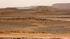
<< Text Pages >> Jbel Kfiroun burial mounds - Cairn in Morocco
Submitted by KaiHofmann on Thursday, 18 April 2019 Page Views: 538
Neolithic and Bronze AgeSite Name: Jbel Kfiroun burial moundsCountry: Morocco
NOTE: This site is 173.53 km away from the location you searched for.
Type: Cairn
Nearest Town: Merzouga Nearest Village: Taouz
Latitude: 30.897920N Longitude: 4.03064W
Condition:
| 5 | Perfect |
| 4 | Almost Perfect |
| 3 | Reasonable but with some damage |
| 2 | Ruined but still recognisable as an ancient site |
| 1 | Pretty much destroyed, possibly visible as crop marks |
| 0 | No data. |
| -1 | Completely destroyed |
| 5 | Superb |
| 4 | Good |
| 3 | Ordinary |
| 2 | Not Good |
| 1 | Awful |
| 0 | No data. |
| 5 | Can be driven to, probably with disabled access |
| 4 | Short walk on a footpath |
| 3 | Requiring a bit more of a walk |
| 2 | A long walk |
| 1 | In the middle of nowhere, a nightmare to find |
| 0 | No data. |
| 5 | co-ordinates taken by GPS or official recorded co-ordinates |
| 4 | co-ordinates scaled from a detailed map |
| 3 | co-ordinates scaled from a bad map |
| 2 | co-ordinates of the nearest village |
| 1 | co-ordinates of the nearest town |
| 0 | no data |
Internal Links:
External Links:
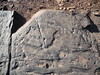
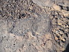
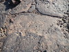
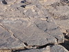
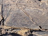
Round Cairn in Morocco
Several stone tumuli with burial chamber. Further tumuli and some rock engravings of animals and a small stone circle in a valley nearby.
You may be viewing yesterday's version of this page. To see the most up to date information please register for a free account.
Do not use the above information on other web sites or publications without permission of the contributor.
Nearby Images from Flickr
The above images may not be of the site on this page, but were taken nearby. They are loaded from Flickr so please click on them for image credits.
Click here to see more info for this site
Nearby sites
Click here to view sites on an interactive map of the areaKey: Red: member's photo, Blue: 3rd party photo, Yellow: other image, Green: no photo - please go there and take one, Grey: site destroyed
Download sites to:
KML (Google Earth)
GPX (GPS waypoints)
CSV (Garmin/Navman)
CSV (Excel)
To unlock full downloads you need to sign up as a Contributory Member. Otherwise downloads are limited to 50 sites.
Turn off the page maps and other distractions
Nearby sites listing. In the following links * = Image available
4.2km N 4° Taouz gravures rupestres Rock Art
156.0km W 262° Ait Ouazik gravures rupestres* Rock Art
156.2km W 262° Ait Ouazik Burial Mounds* Barrow Cemetery
156.3km W 262° Ait Ouazik Menhir* Standing Stone (Menhir)
185.5km SW 234° Tagounite barrow cemetery* Barrow Cemetery
298.6km ENE 62° Figuig Rock Art* Rock Art
366.7km W 276° Oukaimeden* Rock Art
375.7km NNW 330° Rock Shelter near Khemisset Cave or Rock Shelter
381.1km NNW 338° Volubilis* Ancient Village or Settlement
433.5km NW 324° Chellah* Ancient Village or Settlement
435.7km WSW 248° Oum el Alek Gravures rupestres Rock Art
446.2km NNW 330° Thamusida* Ancient Village or Settlement
455.8km NNW 335° Banasa* Ancient Village or Settlement
461.2km NNE 19° Grotte des Pigeons Cave or Rock Shelter
484.9km NW 304° Karikon Teichos Ancient Village or Settlement
493.7km WSW 256° Tazca gravures rupestres* Rock Art
496.5km WNW 303° Akra Ancient Village or Settlement
506.5km WSW 248° Foum el Hassane gravures rupestres Rock Art
515.9km NNW 339° Lixus* Ancient Village or Settlement
531.8km NNW 341° Msoura* Stone Circle
537.1km WSW 250° Tamghilt N'zerzem* Rock Art
542.2km WSW 253° Boutrouch Rock Art Rock Art
543.2km NNW 342° Ad Mercuri* Ancient Village or Settlement
551.4km W 278° Mogador* Promontory Fort / Cliff Castle
587.2km NNW 346° Tarifa Castro or Chafurdão
View more nearby sites and additional images


 We would like to know more about this location. Please feel free to add a brief description and any relevant information in your own language.
 Wir möchten mehr über diese Stätte erfahren. Bitte zögern Sie nicht, eine kurze Beschreibung und relevante Informationen in Deutsch hinzuzufügen.
 Nous aimerions en savoir encore un peu sur les lieux. S'il vous plaît n'hesitez pas à ajouter une courte description et tous les renseignements pertinents dans votre propre langue.
 Quisieramos informarnos un poco más de las lugares. No dude en añadir una breve descripción y otros datos relevantes en su propio idioma.