


<< Our Photo Pages >> Pierres de Mère et Fille - Standing Stones in France in Pays de la Loire:Sarthe (72)
Submitted by TheCaptain on Saturday, 16 April 2005 Page Views: 3172
Neolithic and Bronze AgeSite Name: Pierres de Mère et FilleCountry: France
NOTE: This site is 15.575 km away from the location you searched for.
Département: Pays de la Loire:Sarthe (72) Type: Standing Stones
Nearest Town: La Flèche Nearest Village: St-Jean-de-la-Motte
Latitude: 47.783400N Longitude: 0.090100E
Condition:
| 5 | Perfect |
| 4 | Almost Perfect |
| 3 | Reasonable but with some damage |
| 2 | Ruined but still recognisable as an ancient site |
| 1 | Pretty much destroyed, possibly visible as crop marks |
| 0 | No data. |
| -1 | Completely destroyed |
| 5 | Superb |
| 4 | Good |
| 3 | Ordinary |
| 2 | Not Good |
| 1 | Awful |
| 0 | No data. |
| 5 | Can be driven to, probably with disabled access |
| 4 | Short walk on a footpath |
| 3 | Requiring a bit more of a walk |
| 2 | A long walk |
| 1 | In the middle of nowhere, a nightmare to find |
| 0 | No data. |
| 5 | co-ordinates taken by GPS or official recorded co-ordinates |
| 4 | co-ordinates scaled from a detailed map |
| 3 | co-ordinates scaled from a bad map |
| 2 | co-ordinates of the nearest village |
| 1 | co-ordinates of the nearest town |
| 0 | no data |
Internal Links:
External Links:
I have visited· I would like to visit
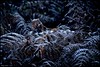
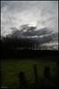
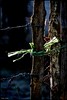
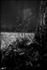
TheCaptain visited on 29th Aug 2005 - their rating: Cond: 4 Amb: 4 Access: 5 The mother and daughter stones can be easily found in the forest to the northeast of La Fleche, and are signposted from nearby. Both are nicely shaped pointed slabs, and they are about 8 metres from each other in an east west direction. The mother stone is more than 4 metres tall, and is the western of the pair, The daughter is just over 2 metres tall, and at the east. It is stated on a nearby signpost that the stones are thought to represent the sun and moon, although the evidence for this is not stated.
")
The mother stone is more than 4 metres tall, and is the western of the pair. The daughter is just over 2 metres tall, and at the east. Both are nicely shaped pointed slabs, and they are about 8 metres from each other in an east west direction.
It is stated on a nearby signpost that the stones are thought to represent the sun and moon, although the evidence for this is not stated.
IMPORTANT NOTE: Positional co-ordinates taken from a gps receiver.
You may be viewing yesterday's version of this page. To see the most up to date information please register for a free account.
")
Do not use the above information on other web sites or publications without permission of the contributor.
Nearby Images from Flickr
The above images may not be of the site on this page, but were taken nearby. They are loaded from Flickr so please click on them for image credits.
Click here to see more info for this site
Nearby sites
Click here to view sites on an interactive map of the areaKey: Red: member's photo, Blue: 3rd party photo, Yellow: other image, Green: no photo - please go there and take one, Grey: site destroyed
Download sites to:
KML (Google Earth)
GPX (GPS waypoints)
CSV (Garmin/Navman)
CSV (Excel)
To unlock full downloads you need to sign up as a Contributory Member. Otherwise downloads are limited to 50 sites.
Turn off the page maps and other distractions
Nearby sites listing. In the following links * = Image available
427m SE 133° Pierre Potelée* Standing Stone (Menhir)
8.4km N 1° la Pierre Couverte (Parigné)* Burial Chamber or Dolmen
14.4km SE 124° Dolmen de la Pierre Aubigné* Burial Chamber or Dolmen
14.5km SE 126° Allée Couverte du Colombier Passage Grave
15.2km SE 125° Menhir du Château de Bossé Standing Stone (Menhir)
17.2km SE 141° Dolmen du Théatre Gallo-Romain de Cherré* Burial Chamber or Dolmen
17.6km ENE 68° Les Pierres Tournantes* Standing Stones
20.0km ESE 118° Dolmen dit Pierre Couverte de Vaas Burial Chamber or Dolmen
20.4km SE 143° Amenon Dolmen* Burial Chamber or Dolmen
22.1km E 94° Perray menhir Standing Stone (Menhir)
22.2km S 170° L'Aurière menhir Standing Stone (Menhir)
22.5km S 170° Dolmen de Laurière Burial Chamber or Dolmen
22.6km SSE 161° Dolmen du Moulin à Vent Burial Chamber or Dolmen
23.1km SSE 168° La Pierre Couverte de la Planche* Burial Chamber or Dolmen
24.2km SSE 165° Dolmen de Chantepierre Burial Chamber or Dolmen
24.4km SSE 167° Dolmen de Bareil Burial Chamber or Dolmen
26.4km NNE 18° Menhir dit Pierre Saint-Julien* Standing Stone (Menhir)
26.6km NNE 18° Musée de Tessé* Museum
27.5km SSW 209° La Pierre Frite Standing Stone (Menhir)
28.0km SE 141° Dolmen de la Pierre Levée (Villiers-au-Bouin) Burial Chamber or Dolmen
28.0km SSW 200° Pierre du Géant (Pontigné) Standing Stone (Menhir)
28.3km SSE 159° Dolmen de la Bénardière Burial Chamber or Dolmen
28.4km SSW 205° Menhir de la Motte Standing Stone (Menhir)
28.5km SSW 205° Polissoir de la Motte Polissoir
28.6km SSW 205° Pierre Couverte (Pontigné)* Passage Grave
View more nearby sites and additional images

 We would like to know more about this location. Please feel free to add a brief description and any relevant information in your own language.
 Wir möchten mehr über diese Stätte erfahren. Bitte zögern Sie nicht, eine kurze Beschreibung und relevante Informationen in Deutsch hinzuzufügen.
 Nous aimerions en savoir encore un peu sur les lieux. S'il vous plaît n'hesitez pas à ajouter une courte description et tous les renseignements pertinents dans votre propre langue.
 Quisieramos informarnos un poco más de las lugares. No dude en añadir una breve descripción y otros datos relevantes en su propio idioma.