 with our Megalithic Portal iPhone app")


<< Image Pages >> Cingle de la Mola - Cave or Rock Shelter in Spain in Comunidad Valenciana
Submitted by durhamnature on Wednesday, 14 November 2012 Page Views: 5494
Natural PlacesSite Name: Cingle de la MolaCountry: Spain
NOTE: This site is 10.75 km away from the location you searched for.
Region: Comunidad Valenciana Type: Cave or Rock Shelter
Nearest Town: Valencia Nearest Village: Remigia
Latitude: 40.417956N Longitude: 0.121948W
Condition:
| 5 | Perfect |
| 4 | Almost Perfect |
| 3 | Reasonable but with some damage |
| 2 | Ruined but still recognisable as an ancient site |
| 1 | Pretty much destroyed, possibly visible as crop marks |
| 0 | No data. |
| -1 | Completely destroyed |
| 5 | Superb |
| 4 | Good |
| 3 | Ordinary |
| 2 | Not Good |
| 1 | Awful |
| 0 | No data. |
| 5 | Can be driven to, probably with disabled access |
| 4 | Short walk on a footpath |
| 3 | Requiring a bit more of a walk |
| 2 | A long walk |
| 1 | In the middle of nowhere, a nightmare to find |
| 0 | No data. |
| 5 | co-ordinates taken by GPS or official recorded co-ordinates |
| 4 | co-ordinates scaled from a detailed map |
| 3 | co-ordinates scaled from a bad map |
| 2 | co-ordinates of the nearest village |
| 1 | co-ordinates of the nearest town |
| 0 | no data |
Internal Links:
External Links:
")
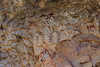
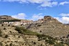
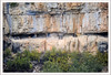
300 items of rock art paintings. One of the caves included in the Spanish Caves World Heritage Site, which covers most of the caves with prehistoric cave art. Many are open to the public.
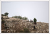
60 metres east of Cueva Remigia. Free admission, closed on Mondays and Thursdays.
You may be viewing yesterday's version of this page. To see the most up to date information please register for a free account.
")
")
")
Do not use the above information on other web sites or publications without permission of the contributor.
Nearby Images from Flickr
The above images may not be of the site on this page, but were taken nearby. They are loaded from Flickr so please click on them for image credits.
Click here to see more info for this site
Nearby sites
Click here to view sites on an interactive map of the areaKey: Red: member's photo, Blue: 3rd party photo, Yellow: other image, Green: no photo - please go there and take one, Grey: site destroyed
Download sites to:
KML (Google Earth)
GPX (GPS waypoints)
CSV (Garmin/Navman)
CSV (Excel)
To unlock full downloads you need to sign up as a Contributory Member. Otherwise downloads are limited to 50 sites.
Turn off the page maps and other distractions
Nearby sites listing. In the following links * = Image available
120m W 265° Cueva Remigia* Cave or Rock Shelter
18.9km N 2° L'Argilagar VI Ancient Village or Settlement
18.9km N 2° L'Argilagar II Burial Chamber or Dolmen
18.9km N 2° L'Argilagar I Burial Chamber or Dolmen
21.9km N 5° Argilagar Castro or Chafurdão
36.4km SSE 148° Mortotum* Ancient Village or Settlement
53.4km ENE 73° Poblat Ibèric de la Moleta del Remei Ancient Village or Settlement
64.7km NNE 23° Cista protohistòrica de Querete Burial Chamber or Dolmen
65.1km NNE 23° Cretas Cuevas* Cave or Rock Shelter
68.4km N 0° Cabezo Sellado Castro or Chafurdão
70.2km NNE 22° Poblado Ibérico de San Antonio Ancient Village or Settlement
70.3km N 0° Palao Castro or Chafurdão
80.2km NW 307° Rio Martin Castro or Chafurdão
82.0km NNE 31° Necrópolis Protohistòrica Del Coll del Moro* Barrow Cemetery
83.4km W 264° Rodenas Castro or Chafurdão
83.5km S 189° Seguntum* Ancient Village or Settlement
84.6km NNW 337° Albate del Arzobispo Castro or Chafurdão
88.4km W 261° Penalba de Villastar Castro or Chafurdão
99.0km N 350° Valimana Castro or Chafurdão
101.7km W 265° Pena de la Cruz Castro or Chafurdão
104.3km SW 228° Cueva de la Vieja* Cave or Rock Shelter
106.8km SSW 192° Museu de Prehistòria de València* Museum
108.1km W 269° Arte rupestre en Albarracín* Cave or Rock Shelter
108.8km NNE 25° Almatret Castro or Chafurdão
111.0km W 269° Masada de Ligros Castro or Chafurdão
View more nearby sites and additional images


 We would like to know more about this location. Please feel free to add a brief description and any relevant information in your own language.
 Wir möchten mehr über diese Stätte erfahren. Bitte zögern Sie nicht, eine kurze Beschreibung und relevante Informationen in Deutsch hinzuzufügen.
 Nous aimerions en savoir encore un peu sur les lieux. S'il vous plaît n'hesitez pas à ajouter une courte description et tous les renseignements pertinents dans votre propre langue.
 Quisieramos informarnos un poco más de las lugares. No dude en añadir una breve descripción y otros datos relevantes en su propio idioma.