

<< Our Photo Pages >> Wallace's Stone (Blairstone Mains) - Early Christian Sculptured Stone in Scotland in South Ayrshire
Submitted by markj99 on Monday, 24 June 2019 Page Views: 2680
Early MedievalSite Name: Wallace's Stone (Blairstone Mains) Alternative Name: BlairstaneCountry: Scotland
NOTE: This site is 1.2 km away from the location you searched for.
County: South Ayrshire Type: Early Christian Sculptured Stone
Nearest Town: Ayr Nearest Village: Alloway
Map Ref: NS3321416579
Latitude: 55.414669N Longitude: 4.636357W
Condition:
| 5 | Perfect |
| 4 | Almost Perfect |
| 3 | Reasonable but with some damage |
| 2 | Ruined but still recognisable as an ancient site |
| 1 | Pretty much destroyed, possibly visible as crop marks |
| 0 | No data. |
| -1 | Completely destroyed |
| 5 | Superb |
| 4 | Good |
| 3 | Ordinary |
| 2 | Not Good |
| 1 | Awful |
| 0 | No data. |
| 5 | Can be driven to, probably with disabled access |
| 4 | Short walk on a footpath |
| 3 | Requiring a bit more of a walk |
| 2 | A long walk |
| 1 | In the middle of nowhere, a nightmare to find |
| 0 | No data. |
| 5 | co-ordinates taken by GPS or official recorded co-ordinates |
| 4 | co-ordinates scaled from a detailed map |
| 3 | co-ordinates scaled from a bad map |
| 2 | co-ordinates of the nearest village |
| 1 | co-ordinates of the nearest town |
| 0 | no data |
Internal Links:
External Links:
 (PID:198961)")
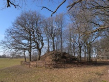
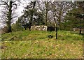
Wallace's stone is situated at Blairston Mains, the 1st non-private left turn on the B7024 to Maybole after leaving Alloway.
The stone is surrounded by a solid stane wall in a strip of trees. The carving is suggested as a representation of Wallace's sword but looks more like a cross to me, however some interpretation is required.
Note: This boulder is recorded as a cross incised stone - see Canmore ID 41595 which refers to an 1895 description which reads: "The incised figure, popularly believed to represent the sword of Wallace, is a cross, 3ft 6ins long and 14ins over the arms". A more recent entry from 100 years later adds: "An irregularly shaped boulder, bearing on one face a cross in false relief, is set within a walled enclosure on the S side of a track 180m NW of Blairstone Mains. The boulder (1.8m long, up to 1m broad and 0.6m thick) has been removed from its former position 30m to the SE (NS 3322 1654) and may originally have been standing".
You may be viewing yesterday's version of this page. To see the most up to date information please register for a free account.
 (PID:198962)")
 (PID:198960)")
Do not use the above information on other web sites or publications without permission of the contributor.
Nearby Images from Geograph Britain and Ireland:

©2024(licence)

©2009(licence)
©2009(licence)
©2015(licence)
©2015(licence)
The above images may not be of the site on this page, they are loaded from Geograph.
Please Submit an Image of this site or go out and take one for us!
Click here to see more info for this site
Nearby sites
Key: Red: member's photo, Blue: 3rd party photo, Yellow: other image, Green: no photo - please go there and take one, Grey: site destroyed
Download sites to:
KML (Google Earth)
GPX (GPS waypoints)
CSV (Garmin/Navman)
CSV (Excel)
To unlock full downloads you need to sign up as a Contributory Member. Otherwise downloads are limited to 50 sites.
Turn off the page maps and other distractions
Nearby sites listing. In the following links * = Image available
2.3km NNW 334° Stonefield Park, Ayr* Standing Stone (Menhir) (NS32271869)
4.3km ESE 122° Barbieston Farm cist* Cist (NS36751417)
6.6km SSW 198° Lyonston Stone* Standing Stone (Menhir) (NS30991039)
7.3km SW 227° Howmoor* Stone Fort or Dun (NS2770711809)
8.3km N 8° Bruce's Well (Prestwick)* Holy Well or Sacred Spring (NS3467624801)
9.2km SW 232° Balchriston* Stone Fort or Dun (NS2572911176)
9.8km SSW 198° Kildoon Hillfort* Hillfort (NS29860738)
11.5km N 11° The Muckle Stane (Monkton)* Natural Stone / Erratic / Other Natural Feature (NS3578027790)
13.8km SSW 198° Captain's Bridge (Drummochreen) W* Hillfort (NS28510356)
13.9km SSW 198° Captain's Bridge (Drummochreen) SE* Stone Fort or Dun (NS28530351)
14.3km NE 41° Tarbolton Cist* Cist (NS4327)
14.4km SSW 208° East Threave* Cairn (NS25870411)
14.6km SW 229° Shanter Knowe* Artificial Mound (NS21890738)
15.0km NE 48° Coilsfield (Tarbolton) Rock Art (NS44692624)
15.0km NE 48° Tarbolton Tumulus Cairn (NS4469926247)
15.2km SW 232° Bains Hill* Standing Stone (Menhir) (NS20750773)
15.8km SSW 202° Cairn Hill (Dalquharran)* Cairn (NS26690219)
16.1km S 174° Knockinculloch* Ancient Village or Settlement (NS34200050)
16.2km N 8° Harpercroft Hillfort* Hillfort (NS36003252)
16.4km N 7° Wardlaw Hill Fort* Hillfort (NS35923276)
17.2km N 6° Kemp Law* Stone Fort or Dun (NS35583364)
18.2km N 8° Dun Donald Hillfort (NS36363451)
18.3km NNE 29° Witches Stane (Craigie) Natural Stone / Erratic / Other Natural Feature (NS42683231)
18.5km NNE 27° Craigie Hill Fort Hillfort (NS42243276)
18.5km NE 40° Loch Lee Crannog* Crannog (NS45753027)
View more nearby sites and additional images


 We would like to know more about this location. Please feel free to add a brief description and any relevant information in your own language.
 Wir möchten mehr über diese Stätte erfahren. Bitte zögern Sie nicht, eine kurze Beschreibung und relevante Informationen in Deutsch hinzuzufügen.
 Nous aimerions en savoir encore un peu sur les lieux. S'il vous plaît n'hesitez pas à ajouter une courte description et tous les renseignements pertinents dans votre propre langue.
 Quisieramos informarnos un poco más de las lugares. No dude en añadir una breve descripción y otros datos relevantes en su propio idioma.