<< Our Photo Pages >> Shasgar - Court Tomb in Ireland (Republic of) in Co. Leitrim
Submitted by Anthony_Weir on Sunday, 13 October 2002 Page Views: 7077
Neolithic and Bronze AgeSite Name: ShasgarCountry: Ireland (Republic of)
NOTE: This site is 3.323 km away from the location you searched for.
County: Co. Leitrim Type: Court Tomb
Nearest Town: Manorhamilton Nearest Village: Rossinver
Map Ref: G896504
Discovery Map Number: D16
Latitude: 54.402106N Longitude: 8.160883W
Condition:
| 5 | Perfect |
| 4 | Almost Perfect |
| 3 | Reasonable but with some damage |
| 2 | Ruined but still recognisable as an ancient site |
| 1 | Pretty much destroyed, possibly visible as crop marks |
| 0 | No data. |
| -1 | Completely destroyed |
| 5 | Superb |
| 4 | Good |
| 3 | Ordinary |
| 2 | Not Good |
| 1 | Awful |
| 0 | No data. |
| 5 | Can be driven to, probably with disabled access |
| 4 | Short walk on a footpath |
| 3 | Requiring a bit more of a walk |
| 2 | A long walk |
| 1 | In the middle of nowhere, a nightmare to find |
| 0 | No data. |
| 5 | co-ordinates taken by GPS or official recorded co-ordinates |
| 4 | co-ordinates scaled from a detailed map |
| 3 | co-ordinates scaled from a bad map |
| 2 | co-ordinates of the nearest village |
| 1 | co-ordinates of the nearest town |
| 0 | no data |
Internal Links:
External Links:
")
Its gallery seems to be unsegmented, with good enty-jambs and excellent corbelling of large and small slabs in several tiers on both sides. The cairn is partly peat-covered and survives to the height of the (missing) gallery roof. The S side of the very deep (possibly Full-) court is fairly well-preserved.
~ Almost 13 kms due S, at Tullyskeherny (SE of Manorhamilton), situated in wild landscape beside a remarkable limestone outcrop resembling the Burren of county Clare (G 899369), and containing boulders and formations of bizarre shapes, many of them perforated, is a pair of court-tombs built of the same limestone crag and in places indistinguishable from it. The graves are on the same axis, and set back to back only 5 metres apart. The more northerly consists of a long cairn with remains of a long narrow forecourt leading into an antechamber and two main chambers. Beside this gallery are no fewer than 6 subsidiary chambers opening on to the long sides of the cairn, some asymmetrically arranged and on different axes to that of the cairn, which seems to have been built directly onto bedrock. Some cairn material has been used in making the nearby track.
The southerly tomb consists of a 2-chambered gallery set in a large oval cairn 24 metres long and approached through the remains of a forecourt. As with the other tomb, both forecourt and gallery are deeply embedded in the cairn, and the gallery is almost completely filled with rubble.
The site commands splendid views.
~ 12 kms SW is the wedge-tomb at Dartry, county Sligo.
You may be viewing yesterday's version of this page. To see the most up to date information please register for a free account.
")
Do not use the above information on other web sites or publications without permission of the contributor.
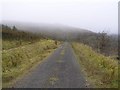
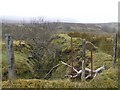
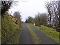
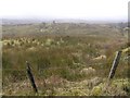
Nearby Images from Geograph Britain and Ireland:
©2009(licence)
©2009(licence)
©2009(licence)
©2009(licence)
©2009(licence)
The above images may not be of the site on this page, they are loaded from Geograph.
Please Submit an Image of this site or go out and take one for us!
Click here to see more info for this site
Nearby sites
Click here to view sites on an interactive map of the areaKey: Red: member's photo, Blue: 3rd party photo, Yellow: other image, Green: no photo - please go there and take one, Grey: site destroyed
Download sites to:
KML (Google Earth)
GPX (GPS waypoints)
CSV (Garmin/Navman)
CSV (Excel)
To unlock full downloads you need to sign up as a Contributory Member. Otherwise downloads are limited to 50 sites.
Turn off the page maps and other distractions
Nearby sites listing. In the following links * = Image available
6.5km WNW 303° Gorteendarragh Wedge Tomb* Wedge Tomb
8.1km ESE 115° Kilcoo Stone Circle (G970470)
11.2km WSW 239° Dartry* Wedge Tomb (G799447)
12.3km E 88° Skaghlea Cairn Court Tomb (H01985070)
12.6km SE 127° Corracloona* Court Tomb (G997428)
12.7km W 268° Tievebaun Burial Chamber or Dolmen
12.8km NNE 14° Creevery Upper* Chambered Tomb (G92766277)
13.2km NW 304° Tullaghan Cross* Ancient Cross
14.4km N 357° Twomilestone Standing Stone (Menhir) (G890648)
15.3km WSW 242° Formoyle Crannog* Crannog
15.8km ESE 122° Corraderrybrock Stone Circle (H030420)
17.3km E 89° Rossinure Beg Court Tomb (H06915053)
17.5km E 87° Doagh Glebe Promontory Fort / Cliff Castle (H0709051350)
17.5km WSW 245° Glencar Upper Crannog* Crannog
18.0km E 90° Rossinure More Court Tomb (H07715039)
18.1km WNW 283° Creevykeel* Court Tomb (G7192054549)
18.5km ESE 118° Cloghastuckane Stone Circle (H059416)
18.6km ESE 118° Toppan Stone Circle (H060415)
19.5km ESE 122° Kilrooskagh Portal Tomb (H06143998)
19.8km SW 226° Magheraghanrush* Court Tomb (G753367)
20.6km SE 128° St Brigid' Stones Stone Row / Alignment (H059378)
20.6km SE 128° Killinagh* Rock Art (H059378)
21.1km ESE 119° Cloghbrack Stone Circle (H080400)
21.1km ESE 109° Aghanaglack Court Tomb (H096435)
22.1km ENE 58° Boa Island* Sculptured Stone (H0851261971)
View more nearby sites and additional images


 We would like to know more about this location. Please feel free to add a brief description and any relevant information in your own language.
 Wir möchten mehr über diese Stätte erfahren. Bitte zögern Sie nicht, eine kurze Beschreibung und relevante Informationen in Deutsch hinzuzufügen.
 Nous aimerions en savoir encore un peu sur les lieux. S'il vous plaît n'hesitez pas à ajouter une courte description et tous les renseignements pertinents dans votre propre langue.
 Quisieramos informarnos un poco más de las lugares. No dude en añadir una breve descripción y otros datos relevantes en su propio idioma.