


<< Other Photo Pages >> Tetney Log Coffin Burial - Round Barrow(s) in England in Lincolnshire
Submitted by Anne T on Saturday, 28 February 2026 Page Views: 1654
Neolithic and Bronze AgeSite Name: Tetney Log Coffin Burial Alternative Name: Tetney Golf Course Barrow, Tetney CoffinCountry: England
NOTE: This site is 0.8 km away from the location you searched for.
County: Lincolnshire Type: Round Barrow(s)
Nearest Town: Grimsby Nearest Village: Tetney
Map Ref: TA3064300616
Latitude: 53.486048N Longitude: 0.032544W
Condition:
| 5 | Perfect |
| 4 | Almost Perfect |
| 3 | Reasonable but with some damage |
| 2 | Ruined but still recognisable as an ancient site |
| 1 | Pretty much destroyed, possibly visible as crop marks |
| 0 | No data. |
| -1 | Completely destroyed |
| 5 | Superb |
| 4 | Good |
| 3 | Ordinary |
| 2 | Not Good |
| 1 | Awful |
| 0 | No data. |
| 5 | Can be driven to, probably with disabled access |
| 4 | Short walk on a footpath |
| 3 | Requiring a bit more of a walk |
| 2 | A long walk |
| 1 | In the middle of nowhere, a nightmare to find |
| 0 | No data. |
| 5 | co-ordinates taken by GPS or official recorded co-ordinates |
| 4 | co-ordinates scaled from a detailed map |
| 3 | co-ordinates scaled from a bad map |
| 2 | co-ordinates of the nearest village |
| 1 | co-ordinates of the nearest town |
| 0 | no data |
Internal Links:
External Links:
")
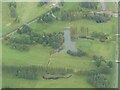
This was in July 2018 during pond-clearing works at Tetney Golf Course, East Lindsey, Lincolnshire. The machine exposed an oak log-coffin containing the remains of a single individual and a hafted miniature battle-axe. A rescue excavation led by Dr Hugh Willmott from the University of Sheffield recorded the surviving depositional context and recovered environmental samples from the broken coffin.
Dendrochronology and radiocarbon wiggle-matching date the felling of the oak to 2032 BC, placing the burial firmly in the Early Bronze Age and making it one of only around 65 known log-coffin burials from Bronze Age Britain. The coffin was formed from a substantial split and hollowed oak log from a fast-growing tree approximately 170 years old, using a split-timber construction technique. Chiselled grooves at either end held vertical slots, and fragments of twine rope indicate the lid was secured by lashing. Large stones, including at least one brought from approximately five kilometres away, were placed on top to weigh down the lid.
The primary burial (SK001) was a robust male in his 30s, standing between 1.75m and 1.83m tall, in good health apart from early osteoarthritis in his left knee. Strontium and oxygen isotope analysis indicates he did not grow up in the immediate vicinity; he may have spent his childhood elsewhere in England or possibly in Continental Europe. The body was laid flexed on a mat of interleaved oak and yew twigs, with a rough pillow of oak twigs at the western end. Pollen analysis revealed a possible garland of sorrel, bird's-foot and corn parsley placed around his head, and a plant-based food offering of cereal grains, black nightshade, white bird's-foot and whole hazelnuts was placed near his abdomen. The burial probably took place in late summer to early autumn of 2032 BC.
The only artefact recovered was a miniature battle-axe with a polished head of distinctive fossiliferous limestone and a perfectly preserved wooden haft. Only 12 such complete hafted examples are known from Britain, making this an exceptionally rare find. The stone may have come from North Yorkshire, which is one of the possible places where isotope analysis suggests the man may have spent time as a child. The axe was highly polished and seemingly unused, interpreted as a symbol of authority and status rather than a practical tool.
The barrow was approximately 25m in diameter, constructed from local silt and gravel scraped up around the burial. At least fourteen other round barrows have been identified in close proximity, either as earthworks or from aerial photographs, indicating this was part of a complex mortuary landscape. A secondary burial, represented only by metatarsals from a second adult, was inserted into the barrow between 2020 and 1875 cal BC, approximately 150 years after the primary interment.
Initial stabilisation of the coffin took place at the Mary Rose Trust, Portsmouth, with full conservation by York Archaeological Trust funded by a £110,000 Historic England grant.
References:
Historic England, "Rare early Bronze Age log coffin discovered on Lincolnshire golf course, 10th September 2021";
University of Sheffield, "Rare early Bronze Age log coffin discovered on Lincolnshire golf course, 10th September 2021";
OAOpen, "An early Bronze Age log-coffin burial from Tetney, Lincolnshire, Willmott, H (Ed), CC By Licence Open Access";
The Past, "Buried in the Bronze Age: unearthing a rare log coffin in Lincolnshire";
York Archaeology Trust, "Bronze-Age Log Coffin Being Conserved by YAT, 8th September 2021";
BSKY Post, "Hugh Willmott, 5th February 2026, Early Bronze Age Coffin Burial Discovered in Tetney"; and
Historic England List ID 1469975, "Round Barrow Cemetery with outlying barrow to the west of Tetney and north of the Waithe Beck". Note: the grid reference given in the excavation report places the coffin on the NNW edge (or just outside) of the barrow.
Information for Visitors:
Condition: Barrow destroyed by mechanical excavator in 2018; coffin and finds recovered and conserved
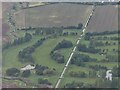
Ambience: Golf course setting, former marshland
Access: On Tetney Golf Course, accessible by road
You may be viewing yesterday's version of this page. To see the most up to date information please register for a free account.
")
")
Do not use the above information on other web sites or publications without permission of the contributor.
Nearby Images from Geograph Britain and Ireland:
©2021(licence)

©2022(licence)
©2021(licence)

©2026(licence)

©2013(licence)
The above images may not be of the site on this page, they are loaded from Geograph.
Please Submit an Image of this site or go out and take one for us!
Click here to see more info for this site
Nearby sites
Key: Red: member's photo, Blue: 3rd party photo, Yellow: other image, Green: no photo - please go there and take one, Grey: site destroyed
Download sites to:
KML (Google Earth)
GPX (GPS waypoints)
CSV (Garmin/Navman)
CSV (Excel)
To unlock full downloads you need to sign up as a Contributory Member. Otherwise downloads are limited to 50 sites.
Turn off the page maps and other distractions
Nearby sites listing. In the following links * = Image available
7.5km N 356° Beacon Hill Barrow (Cleethorpes)* Round Barrow(s) (TA2994408098)
10.1km NNW 326° Toot Hill Round Barrow* Round Barrow(s) (TA24800888)
10.5km WSW 241° Hoe Hill Long Barrow* Long Barrow (TF215953)
10.7km WSW 247° Ash Hill Long Barrow* Long Barrow (TF20889612)
11.6km W 274° Ash Holt Long Barrow* Long Barrow (TA1898001112)
13.1km NW 318° Toot Hill Bowl Barrow Round Barrow(s) (TA21601011)
14.0km NW 312° Ragged Spring (Healing) Holy Well or Sacred Spring (TA199096)
14.0km S 172° Julian Bower Turf Maze (Louth) Maze or Labyrinth (TF32938677)
14.7km WSW 244° Lud well (Stainton-Le-Vale)* Holy Well or Sacred Spring (TF17629376)
15.5km SSW 210° Grims Mound* Round Barrow(s) (TF23258693)
15.7km WSW 240° Bully Hill (Tealby)* Round Barrow(s) (TF17279227)
17.7km WSW 258° Hills Brough* Long Barrow (TF1337396415)
18.1km S 174° Bully Hills* Barrow Cemetery (TF33128272)
18.2km SSW 212° Burgh on Bain* Long Barrow (TF21298497)
18.4km S 185° Tathwell Long Barrow* Long Barrow (TF29458225)
18.5km W 280° Fonaby Stone* Standing Stones (TA123033)
18.7km WSW 245° Walesby All Saints church carvings* Sculptured Stone (TF1382892388)
18.9km W 273° Holy Well (Caistor) Holy Well or Sacred Spring (TA1172501229)
18.9km W 273° Syfer Spring Holy Well or Sacred Spring (TA117012)
18.9km SSW 211° Burgh Top* Round Barrow(s) (TF21458406)
19.1km WNW 297° Brocklesby Park (Great Limber) Cairn (TA1332708902)
20.1km NE 35° Firtholme (Easington) Cairn (TA41601748)
20.7km NNE 31° Easington Beach Henge (TA408187)
22.2km WNW 286° Holy Wells (Barnetby le Wold) Holy Well or Sacred Spring (TA091061)
23.9km SSE 166° Beacon Plantation Long Barrow* Long Barrow (TF372776)
View more nearby sites and additional images


 We would like to know more about this location. Please feel free to add a brief description and any relevant information in your own language.
 Wir möchten mehr über diese Stätte erfahren. Bitte zögern Sie nicht, eine kurze Beschreibung und relevante Informationen in Deutsch hinzuzufügen.
 Nous aimerions en savoir encore un peu sur les lieux. S'il vous plaît n'hesitez pas à ajouter une courte description et tous les renseignements pertinents dans votre propre langue.
 Quisieramos informarnos un poco más de las lugares. No dude en añadir una breve descripción y otros datos relevantes en su propio idioma.