<< Our Photo Pages >> Whissonsett wheel-head cross - Ancient Cross in England in Norfolk
Submitted by willowman1 on Thursday, 09 January 2025 Page Views: 3218
Medieval (High and Late)Site Name: Whissonsett wheel-head crossCountry: England
NOTE: This site is 4.061 km away from the location you searched for.
County: Norfolk Type: Ancient Cross
Nearest Village: Whissonsett
Map Ref: TF91922334
Latitude: 52.773531N Longitude: 0.843691E
Condition:
| 5 | Perfect |
| 4 | Almost Perfect |
| 3 | Reasonable but with some damage |
| 2 | Ruined but still recognisable as an ancient site |
| 1 | Pretty much destroyed, possibly visible as crop marks |
| 0 | No data. |
| -1 | Completely destroyed |
| 5 | Superb |
| 4 | Good |
| 3 | Ordinary |
| 2 | Not Good |
| 1 | Awful |
| 0 | No data. |
| 5 | Can be driven to, probably with disabled access |
| 4 | Short walk on a footpath |
| 3 | Requiring a bit more of a walk |
| 2 | A long walk |
| 1 | In the middle of nowhere, a nightmare to find |
| 0 | No data. |
| 5 | co-ordinates taken by GPS or official recorded co-ordinates |
| 4 | co-ordinates scaled from a detailed map |
| 3 | co-ordinates scaled from a bad map |
| 2 | co-ordinates of the nearest village |
| 1 | co-ordinates of the nearest town |
| 0 | no data |
Internal Links:
External Links:
I have visited· I would like to visit
TipsyTwitcher visited on 12th Nov 2024 - their rating: Cond: 4 Amb: 5 Access: 5
")
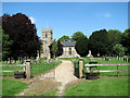
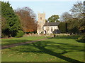
It was discovered in 1900 on the north side of the churchyard when a grave was being dug, although it was several years before it was examined by experts. Made of Barnack limestone, it's said to be of rather crude design, with a fairly simple interlace pattern carved onto both faces. It seems likely to have been a grave-marker not much more than a metre high, on a simple block base.
Further details of this and more than 300 other Norfolk crosses can be found in A Survey of Medieval (and earlier) Freestanding Crosses in Norfolk now live on Willowman's website Hidden East Anglia. A version of the whole Survey is also available as a free pdf download.
Note: Further details of this and more than 300 other Norfolk crosses can be found in 'A Survey of Medieval (and earlier) Freestanding Crosses in Norfolk the website Hidden East Anglia
You may be viewing yesterday's version of this page. To see the most up to date information please register for a free account.
")
Do not use the above information on other web sites or publications without permission of the contributor.
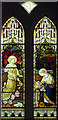
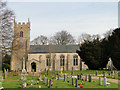
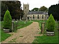
Nearby Images from Geograph Britain and Ireland:
©2009(licence)
©2007(licence)
©2011(licence)
©2017(licence)
©2011(licence)
The above images may not be of the site on this page, they are loaded from Geograph.
Please Submit an Image of this site or go out and take one for us!
Click here to see more info for this site
Nearby sites
Key: Red: member's photo, Blue: 3rd party photo, Yellow: other image, Green: no photo - please go there and take one, Grey: site destroyed
Download sites to:
KML (Google Earth)
GPX (GPS waypoints)
CSV (Garmin/Navman)
CSV (Excel)
To unlock full downloads you need to sign up as a Contributory Member. Otherwise downloads are limited to 50 sites.
Turn off the page maps and other distractions
Nearby sites listing. In the following links * = Image available
6.4km WSW 243° Litcham Heath* Round Barrow(s) (TF863202)
7.1km ESE 106° North Elmham Chapel* Ancient Temple (TF9888121640)
7.5km WSW 244° Weasenham Plantation* Barrow Cemetery (TF853198)
8.0km SSE 161° St Agnes Well, Longham* Holy Well or Sacred Spring (TF94831586)
10.4km W 281° West Rudham* Round Barrow(s) (TF81652495)
10.9km NW 316° Wicken Covert Barrow Round Barrow(s) (TF83973081)
11.0km WNW 283° West Rudham North* Long Barrow (TF8104325337)
11.1km WNW 283° West Rudham Cursus Cursus (TF810254)
11.1km WNW 281° West Rudham South* Long Barrow (TF8094125116)
11.2km NW 313° Coxford Heath Barrow Round Barrow(s) (TF83493070)
12.1km SSE 148° St Withburga's Well* Holy Well or Sacred Spring (TF9865213305)
13.5km N 9° Little Walsingham Holy Well* Holy Well or Sacred Spring (TF93603678)
13.6km N 9° Our Lady of Walsingham Holy Well* Holy Well or Sacred Spring (TF9355136894)
13.8km NNW 331° South Creake* Hillfort (TF848352)
16.1km WNW 299° Bircham Common Barrows* Barrow Cemetery (TF775306)
16.6km E 93° Pettywell* Holy Well or Sacred Spring (TG086230)
17.2km WNW 290° Harpley Common Barrow Cemetery* Barrow Cemetery (TF755287)
17.7km N 10° Warham Camp* Hillfort (TF94374089)
18.2km NNE 16° Fiddler's Hill (Norfolk)* Round Barrow(s) (TF96134105)
18.3km S 190° Devil's Dyke (Norfolk)* Misc. Earthwork (TF8934705200)
19.6km WSW 241° Narborough Camp Hillfort Hillfort (TF75141308)
20.1km ESE 108° The Warren Barrow Round Barrow(s) (TG11371798)
20.5km SW 230° The Cowell Stone Natural Stone / Erratic / Other Natural Feature (TF7673509558)
20.5km NNW 343° Leath House Roman Barrow* Barrow Cemetery (TF852427)
20.9km NNW 336° Burnham Market* Round Barrow(s) (TF826421)
View more nearby sites and additional images


 We would like to know more about this location. Please feel free to add a brief description and any relevant information in your own language.
 Wir möchten mehr über diese Stätte erfahren. Bitte zögern Sie nicht, eine kurze Beschreibung und relevante Informationen in Deutsch hinzuzufügen.
 Nous aimerions en savoir encore un peu sur les lieux. S'il vous plaît n'hesitez pas à ajouter une courte description et tous les renseignements pertinents dans votre propre langue.
 Quisieramos informarnos un poco más de las lugares. No dude en añadir una breve descripción y otros datos relevantes en su propio idioma.