

<< Text Pages >> The White Heath Mounds - Round Barrow(s) in England in Norfolk
Submitted by coldrum on Saturday, 30 May 2026 Page Views: 667
Neolithic and Bronze AgeSite Name: The White Heath MoundsCountry: England
NOTE: This site is 4.0 km away from the location you searched for.
County: Norfolk Type: Round Barrow(s)
Nearest Town: Norwich Nearest Village: Bergh Apton
Map Ref: TG3225000920
Latitude: 52.556523N Longitude: 1.424717E
Condition:
| 5 | Perfect |
| 4 | Almost Perfect |
| 3 | Reasonable but with some damage |
| 2 | Ruined but still recognisable as an ancient site |
| 1 | Pretty much destroyed, possibly visible as crop marks |
| 0 | No data. |
| -1 | Completely destroyed |
| 5 | Superb |
| 4 | Good |
| 3 | Ordinary |
| 2 | Not Good |
| 1 | Awful |
| 0 | No data. |
| 5 | Can be driven to, probably with disabled access |
| 4 | Short walk on a footpath |
| 3 | Requiring a bit more of a walk |
| 2 | A long walk |
| 1 | In the middle of nowhere, a nightmare to find |
| 0 | No data. |
| 5 | co-ordinates taken by GPS or official recorded co-ordinates |
| 4 | co-ordinates scaled from a detailed map |
| 3 | co-ordinates scaled from a bad map |
| 2 | co-ordinates of the nearest village |
| 1 | co-ordinates of the nearest town |
| 0 | no data |
Internal Links:
External Links:
Round Barrow(s) in Norfolk
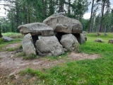
A group of Bronze Age Round Barrows on White Heath, excavated around 1830. One exists as an earthwork, the others are cropmarks.
http://www.heritage.norfolk.gov.uk/record-details?MNF10308-Bronze-Age-round-barrow-earthwork&Index=4&RecordCount=90&SessionID=afcedd6c-2708-439a-a2e5-bcf5efd03f56
http://www.heritage.norfolk.gov.uk/record-details?MNF10309-Bronze-Age-round-barrow-cropmark&Index=5&RecordCount=90&SessionID=1e528c84-fbca-4ce6-8cb5-ae35f9e57606
http://www.heritage.norfolk.gov.uk/record-details?MNF10310-Bronze-Age-round-barrow-cropmark&Index=6&RecordCount=90&SessionID=f3b4395f-1043-43ba-a6b1-53a783f5c0d2
http://www.heritage.norfolk.gov.uk/record-details?MNF10311-Bronze-Age-round-barrow&Index=7&RecordCount=90&SessionID=4533b500-c1ee-46e7-9c36-4771fbc76012
You may be viewing yesterday's version of this page. To see the most up to date information please register for a free account.
Do not use the above information on other web sites or publications without permission of the contributor.
Nearby Images from Geograph Britain and Ireland:

©2009(licence)

©2009(licence)

©2009(licence)

©2009(licence)

©2009(licence)
The above images may not be of the site on this page, they are loaded from Geograph.
Please Submit an Image of this site or go out and take one for us!
Click here to see more info for this site
Nearby sites
Key: Red: member's photo, Blue: 3rd party photo, Yellow: other image, Green: no photo - please go there and take one, Grey: site destroyed
Download sites to:
KML (Google Earth)
GPX (GPS waypoints)
CSV (Garmin/Navman)
CSV (Excel)
To unlock full downloads you need to sign up as a Contributory Member. Otherwise downloads are limited to 50 sites.
Turn off the page maps and other distractions
Nearby sites listing. In the following links * = Image available
8.9km SE 138° Stockton Stone* Standing Stone (Menhir) (TM386946)
9.5km WNW 288° Venta Icenorum* Ancient Village or Settlement (TG230034)
9.7km NW 304° Arminghall Henge* Henge (TG240060)
9.8km S 170° Broome Heath Long Barrow Long Barrow (TM344913)
10.0km S 171° Broome Heath Enclosure Ancient Village or Settlement (TM34289115)
11.3km S 176° Druid's Stone (Bungay)* Natural Stone / Erratic / Other Natural Feature (TM3366689739)
11.9km NW 312° Norwich Castle Museum and Art Gallery* Museum (TG231085)
12.1km WNW 298° Eaton Heath* Barrow Cemetery (TG2128006050)
13.1km WSW 251° Tasburgh Fort* Hillfort (TM201960)
14.7km S 190° Flixton Park Quarry Timber Circle (TM303863)
15.5km E 80° Burgh Castle Shore Fort Stone Fort or Dun (TG474044)
15.7km E 92° Bell Hill Round Barrow(s) (TG480010)
15.7km E 92° Mill Hill Round Barrow(s) (TG480010)
18.1km NW 304° Roundwell* Holy Well or Sacred Spring (TG168104)
18.6km WNW 298° St Walstan's Well* Holy Well or Sacred Spring (TG15350878)
19.9km SSE 156° Brampton Stone* Standing Stone (Menhir) (TM4105783093)
20.2km E 85° Gull Stones (Great Yarmouth) Sculptured Stone (TG524035)
21.6km NNW 335° Fiddler's Hill (Stratton) Long Barrow (TG2225520048)
21.6km W 274° St Thomas's Well (Wymondham)* Holy Well or Sacred Spring (TG10550146)
21.7km NW 324° Horsford Woods Barrow Cemetary* Barrow Cemetery (TG18571780)
23.6km ESE 109° The Witches' Stones, Lowestoft Modern Stone Circle etc (TM5505294359)
24.0km SSE 167° Halesworth And District Museum Museum (TM3884177788)
24.4km N 8° Devil's Ditch Ancient Trackway (TG347252)
26.0km NW 314° Alderford Common Barrow Round Barrow(s) (TG12751828)
26.1km WSW 258° Bunn's Bank Misc. Earthwork (TM0690094200)
View more nearby sites and additional images


 We would like to know more about this location. Please feel free to add a brief description and any relevant information in your own language.
 Wir möchten mehr über diese Stätte erfahren. Bitte zögern Sie nicht, eine kurze Beschreibung und relevante Informationen in Deutsch hinzuzufügen.
 Nous aimerions en savoir encore un peu sur les lieux. S'il vous plaît n'hesitez pas à ajouter une courte description et tous les renseignements pertinents dans votre propre langue.
 Quisieramos informarnos un poco más de las lugares. No dude en añadir una breve descripción y otros datos relevantes en su propio idioma.