


<< Our Photo Pages >> Spettisbury Rings - Hillfort in England in Dorset
Submitted by JimChampion on Tuesday, 11 January 2005 Page Views: 19744
Iron Age and Later PrehistorySite Name: Spettisbury Rings Alternative Name: Spetisbury Rings, Crawford CastleCountry: England
NOTE: This site is 1.1 km away from the location you searched for.
County: Dorset Type: Hillfort
Nearest Town: Blandford Forum Nearest Village: Spetisbury
Map Ref: ST914020
Latitude: 50.817480N Longitude: 2.123446W
Condition:
| 5 | Perfect |
| 4 | Almost Perfect |
| 3 | Reasonable but with some damage |
| 2 | Ruined but still recognisable as an ancient site |
| 1 | Pretty much destroyed, possibly visible as crop marks |
| 0 | No data. |
| -1 | Completely destroyed |
| 5 | Superb |
| 4 | Good |
| 3 | Ordinary |
| 2 | Not Good |
| 1 | Awful |
| 0 | No data. |
| 5 | Can be driven to, probably with disabled access |
| 4 | Short walk on a footpath |
| 3 | Requiring a bit more of a walk |
| 2 | A long walk |
| 1 | In the middle of nowhere, a nightmare to find |
| 0 | No data. |
| 5 | co-ordinates taken by GPS or official recorded co-ordinates |
| 4 | co-ordinates scaled from a detailed map |
| 3 | co-ordinates scaled from a bad map |
| 2 | co-ordinates of the nearest village |
| 1 | co-ordinates of the nearest town |
| 0 | no data |
Internal Links:
External Links:
I have visited· I would like to visit
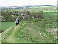
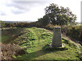
MartynG visited on 1st Aug 2024 - their rating: Cond: 4 Amb: 2 Access: 4 The site is now heavily overgrown. As a footpath runs around the west rampart this is fairly clear but with tall undergrowth on the slopes which restricts any views of the height of the rampart and any outer ditch. The interior of the fort is heavily overgrown by a mixture of nettles, thistles, brambles, and other weeds making access into it from the ramparts impossible.
I will be contacting the landowner with a view to allowing a small work party access to the site to clear the undergrowth over the winter.
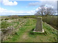
fyrefly visited on 1st Jan 2007 - their rating: Cond: 3 Amb: 4 Access: 3 Visited quite a few times over the years, can still walk along the old railway track. Great views from the top, can see Badbury Rings in the distance.
JimChampion have visited here
Average ratings for this site from all visit loggers: Condition: 3.5 Ambience: 3 Access: 3.5
")
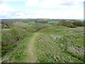
This earthwork looks imposing from the Stour valley, as it sits on the end of a natural spur. The steep face of the spur provides additional defence, but was scarred in modern times by the construction of a railway cutting. According to Aerial archaeology in 1857 the railway navigators "uncovered a mass-grave of about 120 skeletons, probably the victims of the Roman invasion".
Access The Poole-Blandford railway line that cuts through the side of the hillfort was axed in the 1960s, and has recently been improved as part of the off-road cycle network. However, because it is in a cutting it provides no views of, or direct access to, the rings. There are two approaches:
- A public footpath runs NW parallel to the old railway cyclepath from the B3075 (grid ref ST918017). Go along the edge of the field, over the stile into a thorny clump of trees, beyond which is a steep path up the SE rampart.
- An easier approach: turn SW off the A350 in Spetisbury (grid ref ST913024) onto a minor road. Park to the left after passing under the disused railway bridge. Do not take the steps up to the disused railway station! Instead walk a short distance up the hill, take the public footpath into a field on the left (beware of livestock). The entrance to the earthworks will be directly ahead, 200m distant.
You may be viewing yesterday's version of this page. To see the most up to date information please register for a free account.
")
")
")
")
Do not use the above information on other web sites or publications without permission of the contributor.
Nearby Images from Geograph Britain and Ireland:
©2012(licence)
©2009(licence)

©2025(licence)
©2012(licence)
©2010(licence)
The above images may not be of the site on this page, they are loaded from Geograph.
Please Submit an Image of this site or go out and take one for us!
Click here to see more info for this site
Nearby sites
Key: Red: member's photo, Blue: 3rd party photo, Yellow: other image, Green: no photo - please go there and take one, Grey: site destroyed
Download sites to:
KML (Google Earth)
GPX (GPS waypoints)
CSV (Garmin/Navman)
CSV (Excel)
To unlock full downloads you need to sign up as a Contributory Member. Otherwise downloads are limited to 50 sites.
Turn off the page maps and other distractions
Nearby sites listing. In the following links * = Image available
2.0km E 100° Shapwick Round Barrow(s) (ST9336301635)
3.4km ENE 71° Straw Barrow Round Barrow(s) (ST94660312)
3.6km WSW 242° Combs Ditch (Great Coll Wood)* Misc. Earthwork (ST8819000320)
3.9km WSW 247° Combs Ditch (Field)* Misc. Earthwork (ST8781000510)
4.0km ESE 114° Sturminster Marshall Crosses* Ancient Cross (ST9509100379)
4.0km N 7° Buzbury Rings* Ancient Village or Settlement (ST919060)
4.5km ENE 78° Badbury Barrow Barrow Cemetery (ST958029)
4.5km WSW 253° Combs Ditch (Little Coll Wood)* Misc. Earthwork (ST8708000719)
4.7km N 2° Tarrant Rawston Long Barrow* Long Barrow (ST91550667)
4.8km NW 322° Blandford Forum Stones* Standing Stones (ST884058)
5.1km ENE 79° Badbury Rings* Hillfort (ST96400299)
5.1km WSW 259° Combs Ditch (East Down)* Misc. Earthwork (ST8637001000)
5.6km W 268° Combs Ditch (Chariston)* Misc. Earthwork (ST8578001800)
5.8km NNW 338° Pimperne Maze Maze or Labyrinth (ST892074)
6.3km W 272° Combs Ditch (Whatcombe Down)* Misc. Earthwork (ST8508002199)
6.4km N 360° Blandford Race Down Round Barrow(s) (ST91360836)
6.8km SW 230° Winterborne Kingston* Standing Stone (Menhir) (SY8617197690)
6.9km WSW 247° Duropolis Ancient Village or Settlement (SY8505099380)
7.7km ESE 111° The Bearstone* Standing Stone (Menhir) (SY986993)
8.3km ESE 102° Pamphill* Natural Stone / Erratic / Other Natural Feature (ST995003)
8.5km N 2° Pimperne Long Barrow* Long Barrow (ST917105)
8.6km SW 216° Broomhill Barrows* Barrow Cemetery (SY8637095070)
9.2km SW 219° Woodbury Hill (Dorset)* Hillfort (SY856948)
9.4km E 87° Bakers Dozen* Modern Stone Circle etc (SU008024)
9.4km ENE 64° High Lea Farm* Barrow Cemetery (ST999061)
View more nearby sites and additional images


 We would like to know more about this location. Please feel free to add a brief description and any relevant information in your own language.
 Wir möchten mehr über diese Stätte erfahren. Bitte zögern Sie nicht, eine kurze Beschreibung und relevante Informationen in Deutsch hinzuzufügen.
 Nous aimerions en savoir encore un peu sur les lieux. S'il vous plaît n'hesitez pas à ajouter une courte description et tous les renseignements pertinents dans votre propre langue.
 Quisieramos informarnos un poco más de las lugares. No dude en añadir una breve descripción y otros datos relevantes en su propio idioma.