


<< Text Pages >> Boro Wood Camp - Ancient Village or Settlement in England in Devon
Submitted by Bladup on Monday, 15 September 2025 Page Views: 313
Multi-periodSite Name: Boro Wood CampCountry: England
NOTE: This site is 4.492 km away from the location you searched for.
County: Devon Type: Ancient Village or Settlement
Map Ref: SX74867160
Latitude: 50.530754N Longitude: 3.767004W
Condition:
| 5 | Perfect |
| 4 | Almost Perfect |
| 3 | Reasonable but with some damage |
| 2 | Ruined but still recognisable as an ancient site |
| 1 | Pretty much destroyed, possibly visible as crop marks |
| 0 | No data. |
| -1 | Completely destroyed |
| 5 | Superb |
| 4 | Good |
| 3 | Ordinary |
| 2 | Not Good |
| 1 | Awful |
| 0 | No data. |
| 5 | Can be driven to, probably with disabled access |
| 4 | Short walk on a footpath |
| 3 | Requiring a bit more of a walk |
| 2 | A long walk |
| 1 | In the middle of nowhere, a nightmare to find |
| 0 | No data. |
| 5 | co-ordinates taken by GPS or official recorded co-ordinates |
| 4 | co-ordinates scaled from a detailed map |
| 3 | co-ordinates scaled from a bad map |
| 2 | co-ordinates of the nearest village |
| 1 | co-ordinates of the nearest town |
| 0 | no data |
Internal Links:
External Links:
Ancient Village or Settlement in Devon
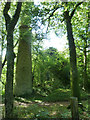
Boro Wood Camp. Hillslope enclosure of probable Iron Age date, situated on the eastern promontory which forms the south-east extremity of Ausewell Hill at approximately 230m OD. The enclosure is approximately elliptical and constructed from stone rubble. The wall or rampart has been heavily robbed. There are several gaps in the wall though none may be identified as an entrance with any confidence.
The enclosure consists of a rubble bank forming an approximately elliptical circuit. It measures 256m by 160m and encloses an area of approximately 4.1ha. There is no obvious evidence of an external ditch. The rampart has been much disturbed and spread in places, and its course has been interrupted at several points, where stone is either partially or completely absent. The strongest and most undisturbed section is on the east side where the rubble stands to a maximum height of 1.5m with a spread of 9m.
You may be viewing yesterday's version of this page. To see the most up to date information please register for a free account.
")
Do not use the above information on other web sites or publications without permission of the contributor.
Nearby Images from Geograph Britain and Ireland:
©2017(licence)
©2017(licence)
©2017(licence)
©2013(licence)
©2013(licence)
The above images may not be of the site on this page, they are loaded from Geograph.
Please Submit an Image of this site or go out and take one for us!
Click here to see more info for this site
Nearby sites
Key: Red: member's photo, Blue: 3rd party photo, Yellow: other image, Green: no photo - please go there and take one, Grey: site destroyed
Download sites to:
KML (Google Earth)
GPX (GPS waypoints)
CSV (Garmin/Navman)
CSV (Excel)
To unlock full downloads you need to sign up as a Contributory Member. Otherwise downloads are limited to 50 sites.
Turn off the page maps and other distractions
Nearby sites listing. In the following links * = Image available
1.9km NW 312° Stidwell* Holy Well or Sacred Spring (SX735729)
2.0km NW 317° Ten Commandments Stone* Natural Stone / Erratic / Other Natural Feature (SX735731)
2.1km NW 321° Buckland Ridge South Ring Cairn (SX73577324)
2.3km SSE 165° St Gudula's Well* Holy Well or Sacred Spring (SX754694)
2.5km W 276° Holne Chase Castle Fort Hillfort (SX72407190)
3.5km W 264° Leigh Tor Round Ancient Village or Settlement (SX71387131)
3.9km SW 214° Hembury Castle* Hillfort (SX7263868449)
3.9km NNW 336° Wittaburrow Cairn* Cairn (SX73347521)
4.0km N 356° Rippon Tor* Cairn (SX74667558)
4.2km NNW 338° Blackslade Down Cairn and Cist* Cist (SX7341275510)
4.4km NNW 344° Foales Arrishes* Ancient Village or Settlement (SX73777587)
4.5km N 351° Stentifords Cross* Marker Stone (SX7424076030)
4.5km NNW 337° Tunhill Rocks* Ancient Village or Settlement (SX7318975796)
4.7km N 350° Seven Lords' Lands* Stone Circle (SX74127623)
5.0km NNW 343° Top Tor row Stone Row / Alignment (SX735764)
5.0km NNW 344° Top Tor Cairns* Cairn (SX7357476472)
5.3km NW 322° Dunstone Cup Stone Rock Art (SX71677585)
6.0km WNW 284° Sherberton Common Multiple Stone Rows / Avenue (SX691732)
6.0km N 359° Holwell Tor Settlement Ancient Village or Settlement (SX74887757)
6.0km NNW 328° Saxon Well* Holy Well or Sacred Spring (SX718768)
6.4km WNW 285° Sherril Down Multiple Stone Rows / Avenue (SX687734)
6.4km WSW 253° Holne Lee* Ring Cairn (SX68666992)
6.6km WNW 285° Ouldsbroom Cross* Ancient Cross (SX6850173504)
6.6km N 5° Smallacombe Rocks Settlement* Ancient Village or Settlement (SX7558378211)
6.8km W 269° Holne Moor North Ring Cairn (SX68097162)
View more nearby sites and additional images


 We would like to know more about this location. Please feel free to add a brief description and any relevant information in your own language.
 Wir möchten mehr über diese Stätte erfahren. Bitte zögern Sie nicht, eine kurze Beschreibung und relevante Informationen in Deutsch hinzuzufügen.
 Nous aimerions en savoir encore un peu sur les lieux. S'il vous plaît n'hesitez pas à ajouter une courte description et tous les renseignements pertinents dans votre propre langue.
 Quisieramos informarnos un poco más de las lugares. No dude en añadir una breve descripción y otros datos relevantes en su propio idioma.